<US 366 | Home | US 371 >
US 70 | US 170 | US 270 | US 470 | US 570
US 370 at US Ends.com
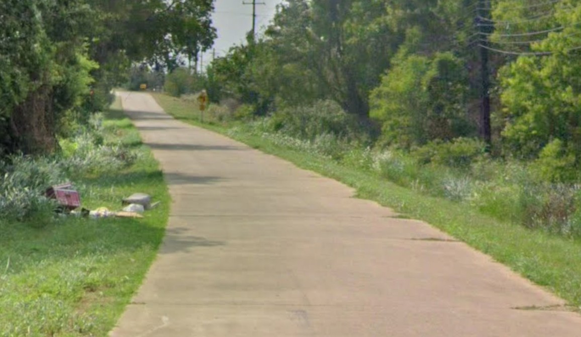
Photo: an old piece of US 370 east of Wichita Falls TX on E. Fort Worth Ave (GMSV, June 2023)
| US 370 twice replaced | ||||||||
| Previous US 370's: Final ROUTE LOG (370 #1) US 80: 0 - 0 US 180: 67 - 67 US 560: 104 - 171 US 70: 11 - 182 Final ROUTE LOG (370 #2) US 60, US 66, US 87: 0 - 0 US 62, US 83: 117 - 117 US 70 WB: 57 - 174 US 283: 1 - 175 US 70 EB: 48 - 223 US 277 NB: 1 - 224 US 82 WB, US 277 SB: 1 - 225 US 281: 1 - 226 US 82 EB: 19 - 245 US 81: 29 - 274 |
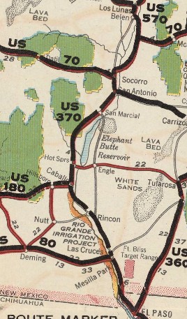
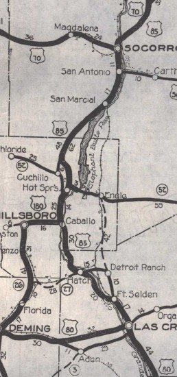
US 370 #1: Appeared in the 1925 iniial US route plan running from US 70 (now Fisher Ave) Socorro NM south to US 80 (now NM 28) Las Cruces NM.
In September 1926 (AASHO), US 370 was renumbered as part of US 85. Today it is Park St and Fairgrounds Rd out of Socorro to the Fairgrounds; abandoned routing to the NE corner of the airport; abandoned southeast along the edge of the airport property to where the terminal is; abandoned southeast across I-25 to Camino Luis Lopez Rd south to NM 1; NM 1 to Pino St in San Antonio; abandoned SE, Montoya St which used to connect to Santa Fe RR St which used to cross NM 1 to Pine St; Pine St/abandoned back to NM 1 for about 7 miles; abandoned along canal opposite Wildlife Dr to curl back to NM 1 at the railroad overpass, then abandoned along the railroad through Tiffany (this area was wiped out by 2 substantial floods in 1929, so it is difficult to see a precise routing) The old route continued on abandoned angling west away from the river to San Marcial; San Marcial Rd southwest 1.4 miles; abandoned southwest 0.8 miles; abandoned northwest 0.25 miles; abandoned west 0.5 miles; abandoned southwest 0.3 miles; abandoned northwest 0.8 miles; abandoned SSW 0.2 miles; abandoned west 1.8 miles to across I-25; private dirt road for about 0.4 miles west; abandoned WSW about 0.7 miles; abandoned southwest 1 mile; abandoned SSW 0.7 miles; abandoned west 0.2 miles; abandoned southwest 4 miles; Scott Ranch Rd to Eaton Ranch Rd; abandoned southwest 2.9 miles; abandoned SSW 2.5 miles, then abandoned 0.2 miles WSW descending Nogal Canyon, then abandoned southeast 0.7 miles to cross the wash at the bottom, then abandoned southeast 0.6 miles ascending Nogal Canyon; driveable but private dirt road southwest 4.4 miles; abandoned 800 ft across Cuervo Canyon; driveable but private dirt road southwest 1.1 miles then southeast 1.1 miles back to NM 1. The old abandoned route then bounces back and forth across NM 1 a total of 4 times down to where I-25 Exit 100 connects to NM 1. After paralleling NM 1 on the east side for 0.3 miles, the old route verrs south as abandoned 0.7 miles; abandoned SSW about 0.1 mile; abandoned southwest 3/4 mile; abandoned SSW 7.4 miles; CR C038 to CR C027 for 1 mile; abandoned SSW 2.3 miles; NM 142 to NM 52, then continuing southeast as abandoned routing to NM 181 near the south end of the Truth or Consequences Airport; NM 181 south; I-25 Bus through Truth or Consequences; I-25 NB offramp at Exit 75; NM 187 for about 0.7 miles; abandoned south, then Paloma Blanca Rd to the east end of Las Palomas; abandoned south 0.2 miles, then abandoned southeast about 0.7 miles; abandoned along the west shore of the Rio Grande River 1.5 miles; abandoned SSW 0.25 miles; abandoned west 1.2 miles; Gordon Ave; NM 187 through Caballo. About Animas Creek Rd, the route veered abandoned SSE to parallel NM 187 down to I-25 Exit 59 where it picked up NM 187 again. In the vicinity of Chile Plant CR B042 south of I-25 Exit 59, the old route veered ESE to cross the Rio Grande about 1700 ft northeast of the I-25 crossing; Old Hot Springs Rd; West River Rosa Rd; Tibbs Rd then NM 436 through Derry; CR E62 Walnut Grove Rd to past NM 187 Garfield; abandoned/CR E55/Nightwatchers Rd/CR E64 to Garfield Rd; south on private dirt road to nearly NM 187; wavy abandoned paralleling NM 187/a little Brad St/abandoned; south on Bent Bow Rd/Silverbell St; NM 390; Salem St through Salem; abandoned southeast to very near I-25; abandoned ESE along the Rio Grande to NM 154; NM 154 east to around MM 3, then abandoned ENE passing north of the Rincon cemetery, then over to Rincon (unclear which street it turned south); NM 140 east to I-25 where the route crossed the railroad and continued on CR 73 about 2 miles, then southeast abandoned about 1400 ft; CR E71 for 5.6 miles; on the other side of I-25, CR E70 for about 9 miles; abandoned/Ft Selden Rd through Radium Springs; Canal Rd; Dona Ana Rd, then Alameda Blvd through Las Cruces, then south on Main St, where it met the 1925 routing of US 80 at Avenida de Mesilla.
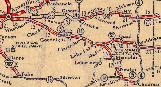
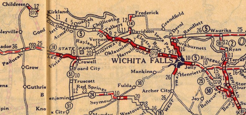
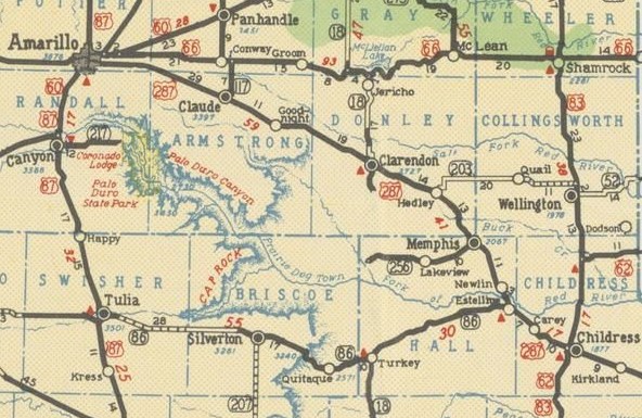
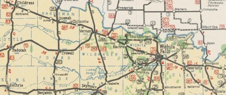
US 370 #2: Appeared in September 1926 (AASHO), replacing part of US 85's 1925 routing. It ran from US 66 (now US 87) Amarillo TX to US 81 (Wise at Smythe) Bowie TX.
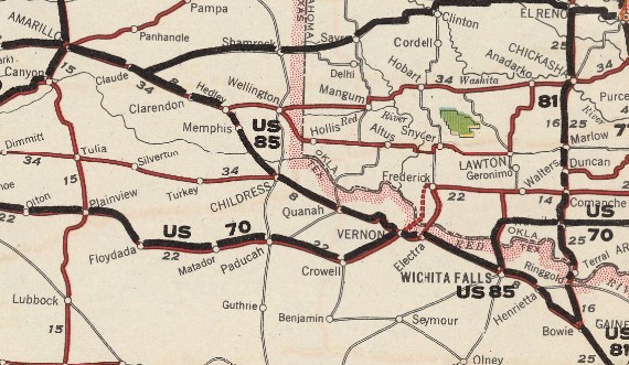 US 85 from Amarillo to Bowie TX 1926 National Hwys Association
About 1927, US 370 was given a more direct routing southeast out of Memphis. The old route: Main St east, which used to cross Parkers Creek, then CR 25 south to just across the RR, then along the railroad east back to US 287; Also, US 370 was given a modern routing from Newlin to below Estelline. The old route: FM 1619 through Newlin; at 0.4 miles from US 287, south on dirt road, then abandoned along the north side of the railroad over an removed causeway/bridge over the Prairie Dog Town Fork of the Red River, eventually picking up Estelline-Memphis Rd which used to angle to McPherson St in Estelline; west on Mystery St and south on Main St, then east on Maud St to end, then south to US 287. Also about 1927, US 370 was given a direct route from Quanah to Chillicothe. The old route: Kings High Rd east; Hamby Rd/McNabb Rd south; Irvin Rd east; also, Dam Site Rd south; Melear Rd east; Lance Rd south 650 ft, then unnamed dirt road east back to US 287. About 1929, US 370 was given a direct route from Estelline to Carey. The old route: FM 658 south 2.3 miles; abandoned east then question mark shape to cross Rustler Creek, then abandoned southeast and SSE 0.6 miles; private dirt road southeast 1.5 miles; CR T east; FM 2466 to Carey. Also about 1929, US 370 was given a direct route from Chillicothe to Vernon. The old route: abandoned RR crosing opposite 4th St Chillicothe; CR 108 east; abandoned SSE from CR 108/Word Rd intersection; abandoned along north side of railroad back to US 287 where it meets CR 112 west of Tolbert. Also about 1929, US 370 in Wichita Falls was removed from Old Iowa Park Rd/Jefferson St/Burkburnett Rd/Wichita St/Ohio Bridge over the Wichita River/Bridge St/Ohio Ave/(cutoff by Spur 447)/Barwise Ave/Mississippi Ave/Jalonick St/Edwards Ave/Ft Worth St (no longer crosses Holiday Creek) all the way out to US 287 Bus just west of TX 79. About 1930, US 370 was given a direct routing from Carey to near Childress. The old route: CR T east; CR 7 south; CR W east 0.9 miles; abandoned east through the Childress airport to pick up CR W again at FM 164; CR W to US 287 In August 1930 (per this newspaper article, Texas abandoned a plan they had back to the beginning of the US route system to route US 66 to meet US 370 at Washburn about 17 miles east of Amarillo. This plan was reflected in AASHO documents trying to clarify where US 66 ran and where US 370 ended. There was much confusion because there was no actual road from Groom southwest to Washburn. So US 370 did go to Amarillo in practice from the start and in August 1930 the intent to truncate it went away. There was so much confusion regarding this that maps had all kinds of configutations with US 370 ending at Washburn, Claude, or even Goodnight. To see all the different mapscans, visit the entire Amarillo page at US Ends.com. About 1931, US 370 was given a direct routing from Childress to Childress/Hardeman line. The old route: Main St south, Ave A east, 5th St south, Ave K out of Childress; CR V east; FM 2530 to end; CR Z east; CR 21 south; CR AA through Kirkland to CR 23 (no longer possible) south to US 287 About 1932, US 370 was removed from abandoned/Country Club Dr/US 62 outside Childress. Also about 1932, US 370 was rebuilt between Childress/Hardeman line and Quanah. The old route included: abandoned along north side of railroad in the FM 268 area; abandoned/Font St/abandoned north side of railroad from Goodlett to Acme; just east of S Groesbuck Cr, abandoned along north side of railroad, Butts Rd across RR, abandoned along south side of railroad to Quanah, where it curved onto 2nd St to downtown. About 1934, US 370 was moved from 10th/Spade Dr/Grand St/Tower Dr to 10th/Tee Anchor Blvd/I-40 WB Frontage Rd in Amarillo. Also about 1934, US 370 was given a more direct route from Claude to Clarendon. The old route used CR 20 south, India Rd east, CR 21 south and Juliet Rd back to current US 287. At Goodnight, the old route crossed the railroad at FM 294 then used Kilo Rd, abandoned segments and other dirt roads through Ashtola, continuing alongside the north side of the railroad to pick up Front St in Clarendon, then back across the railroad on Keamey St. Also about 1934, US 370 was rerouted through Quanah to use 11th St to Loop Rd back to 3rd. The old route used 14th St, TX 6 Main St, then 3rd St west. About 1935, US 370 was given a more direct route from Clarendon to Memphis. The old route CR 13 Airport Rd south 0.6 mi; abandoned east, past US 287; lengthy abandoned along the north side of the railroad; 3rd St into Lelia Lake; FM 1755 across RR; 3rd St back across RR; lengthy abandoned along north side of railroad; CR V, then Railroad St through Hedley; CR W east; CR 28 south to just short of US 287; abandoned wavy routing southeast; CR Z east through Giles Station; CR 29 southeast 0.9 miles; abandoned generally south (a zig zag segment is not very far from CR 29) until reaching the railroad; abandoned along the north side of the railroad; CR 31 southeast until it crosses the railroad to US 287; 10th St south, then Main St into Memphis. Also about 1935, US 370 was rerouted approaching Bowie. The old route: W. Clay St which used to cross the RR to Old Wise Rd at the plastics factory, Old Wise Rd If US 370 ever used the sharper of the two abandoned S curve alignments immediately west of the Harmony Rd interchange near Iowa Park it stopped doing so by 1936. Also about 1936, US 370 was removed from King St between the current US 70-183-287 railroad bridge and Loop 404 in Oklaunion. Also about 1936, US 81 was rerouted in Bowie to its current routing north out of Bowie instead of meeting Wise St via Smythe St. US 370 may have been truncated to US 81 west of downtown at this point. About 1939, US 370 was given a more direct routing east out of Bellevue. The old route: Franklin St, 7th St, Cole St/Gill Rd, Tyson Rd In July 1939 (AASHO), US 370 was replaced in its entirety by US 287.
| |||||||
Previous: US 366 |
Next: US 371
US 70 | US 170 | US 270 | US 470 | US 570
US 370 at US Ends.com
Page last modified 13 August 2026