< VA 42 | Home | VA 44 >
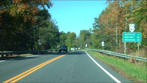
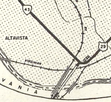
Photo: VA 43 leaving US 29 Bypass Altavista (photo by Mapmikey 10/21/10)
|
|
|
| ROUTE LOG |
US 29 Bus: 0 - 0 US 29: 1.58 - 1.58 Bedford-Campbell Line: 7.74 - 9.42 VA 24 EB: 7.62 - 14.06 VA 24 WB: 2.58 - 16.64 Bedford City-Bedford Line: 8.32 - 24.96 US 460 Bus EB: 1.01 - 25.97 US 221 Bus SB, US 460 Bus WB, VA 122 Bus SB: 0.15 - 26.12 US 221 Bus NB, VA 122 Bus NB: 0.27 - 26.39 Bedford-Bedford City Line: 1.56 - 27.95 BRP Spur: 8.82 - 36.77 GAP IN ROUTE BRP: 0 - 36.77 Botetourt-Bedford Line: 0.11 - 36.88 US 11 SB: 4.64 - 41.52 US 11 NB: 0.18 - 41.70 US 220: 16.59 - 58.29
|
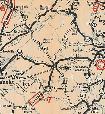
Creation: Appeared in July 1933 as a renumbering of VA 320 from US 29 Altavista to the Bedford County line and a separate piece appeared as a renumbering of VA 215 from SR 628/726 Gillespie north through Bedford and Eagle Rock before ending at SR 615-616 Strom. This is the 2nd VA 43.
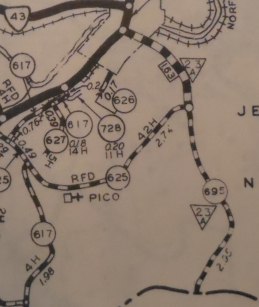
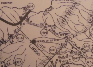
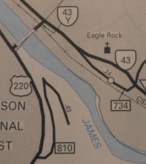
| Adjustments:In 1937, VA 43 was rerouted in Buchanan to its current James River crossing. Before it cut south on Bridge St to cross. In Oct 1938 (CTB), VA 43 was transferred to the National Park Service from Bedford SR 641 to Botetourt SR 625 for inclusion into the coming Blue Ridge Pkwy. Note that the BRP does not fully follow VA 43's old routing and there are some dirt roads visible that parallel the parkway. Additionally, on the Bedford end, VA 43 followed the road that leads to the Peaks of Otter Lake and then connected to current BRP at Peaks of Otter Lodge a little north of where VA 43's road leads to the BRP today.
In April 1944 (CTB), VA 43 was added to SR 714 between VA 24 and the Campbell County line. In May 1945 (CTB), VA 43 north was truncated to US 220 (now SR 870) Eagle Rock, leaving behind SR 615 to Strom. In May 1946 (CTB), VA 43 was added back to Botetourt SR 695 (3.10 miles) and to Bedford SR 764 (2.30 miles) in the Blue Ridge Parkway area. This made a direct connection at both BRP splits.
In March 1952 (CTB), VA 43's approach to US 29 Altavista was moved from 9th and Broad Sts to just Bedford Ave all the way.
In May 1954 (CTB), VA 43 was removed from the SR 643 loop at Peaksville. In April 1965 (CTB), VA 43 was removed from the SR 712 loop west of Lynch Station. Between 1970 and 2000, VA 43 was placed on split routing below Main St in Bedford - NB using Otey St and SB using South St In Feb 1975 (CTB), VA 43 was removed from a piece of SR 649 northwest of Buchanan. In 1979, VA 43 north was extended over what was US 220 to its current endpoint. Improvements: Upon designation VA 43 was paved from Altavista to Leesville; a few miles centered around Bedford; Buchanan to SR 619; a mile into Eagle Rock In 1939, VA 43 was paved from Bedford south to VA 24. In 1941, VA 43 was paved from Eagle Rock south about 8 miles. In 1944, VA 43 was paved on its addition from VA 24 to Campbell County. In 1948, VA 43 was paved from Bedford to Buchanan. In 1950, VA 43 was fully paved when the last piece north of Botetourt SR 619 was paved. There are no multilane segments on VA 43. Posted: Fully posted; last known cutouts were removed from Bedford in early 1990s There are odd 043 rectangle shields in Eagle Rock at varios SR intersections. Multiplexes: VA 24 (2.58 mi) US 460 Bus (0.15 mi) US 221 Bus, VA 122 Bus (0.27 mi) US 11 (0.18 mi) Legislative names: None Other names: Bedford Hwy (Altavista/Campbell Co); Dearing Ford Rd (Bedford Co s of SR 626); Leesville Rd (SR 626 to VA 24); Glenwood Dr (VA 24 duplex); Virginia Byway (VA 24 to Bedford City); South St/Talbot St/Main St/Bridge St/Peaks St (Bedford City); Peaks Rd (Bedford to BRP); Parkway Dr (BRP to Buchanan); Main St/First St (Buchanan); Narrow Passage Rd (Buchanan to Eagle Rock); Second St/Branch Rd/Church St (Eagle Rock) Scenic Byway: Eagle Rock to Blue Ridge Pkwy (since 5/17/90); Altavista to Blue Ridge Pkwy (since 12/17/92) Comment: VA 43 is a difficult drive from Leesville to near VA 24 - in fact there are signs telling drivers to use SR 628 to reach destinations instead of VA 43. In southern Bedford County it is more like a secondary road. From the BRP to Eagle Rock VA 43 is not exactly a speedway either. So. Is VA 43 duplexed with the Blue Ridge Pkwy? The answer is no. THere are signs on VA 43 in both directions indicating to follow parkway to VA 43. However, the traffic logs show the BRP as only VA 48 and not bothe VA 43 and VA 48. Coming from Bedford, it appears that VA 43 turns into a spur of the Blue Ridge Pkwy about 3/4 mile short of the mainline parkway (there is a begin scenic byway sign and reassurance shield well off the parkway). A couple side roads to NPS areas show signage as if it were the mainline BRP. However, at SR 618 literally at the parkway has a rectangle 43 sign indicating the road is VA 43 all the way to the parkway. Plus the mileages add up as if there are no gaps near the Parkway. VA 43 is blown off by I-81. The 1939 VDOT report on primary system development had recommended that VA 43 be decommissioned from Alta Vista to Bedford and also from Buchanan to Eagle Rock. | Previous VA 43's:
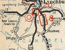
1932 ROUTE LOG VA 10: 0 - 0 US 29 SB, VA 14 SB: 23 - 23 US 29 NB, VA 14 NB: 1 - 24 VA 18 SB: 4 - 28 VA 18 NB: 1 - 29 US 60, VA 10: 10 - 39 |
VA 43 #1: Appeared in AUgust (CTB) as new primary routing, from US 60/VA 10 (current US 460) Concord southwest to VA 18 (Now US 501) Rustburg. A second piece was created from VA 10 (now US 221) Forest south to the Evington area.
In Dec 1930 (CTB), the two pieces were connected. In July 1933, VA 43 was renumbered as VA 127 (now SR 811/854) from Forest to Evington and VA 24 (used SR 754 in the US 29 area) from Evington to Concord.
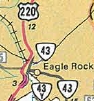
VA 43-Y: Appeared in 1979 as a renumbering of US 220, connecting the new alignment of US 220 to VA 43 in Eagle Rock. About 1998, VA 43-Y was downgraded to SR 870 when the James River bridge was rebuilt. VA 43-Y was on official maps from 1984-96. I did not get by here while it existed but my hunch is that it was posted.
| ||||||||||||||||
Previous: VA 42 |
Next: VA 44
Top | Virginia Hwy Index
Home
Page last modified 28 February 2015