VA 800 to 825
< VA 700 to 728 | Home | VA 826 to 90005 >
VA 801 view
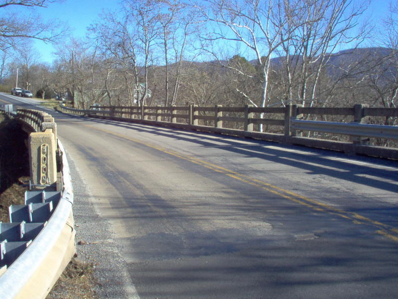
Photo: VA 801's view crossing of SR 688 in Natural Bridge Station, now VA 130 (photo by Mapmikey 1/26/06)
VA 800  not currently assigned
Previous VA 800's:

1932 ROUTE LOG
Alleghany-Craig Line: 0 - 0
US 60 EB, VA 14 EB: 21.32 - 21.32
US 60 WB, VA 14 WB: 1.5 - 21.82
VA 828: 4 - 25.82
Bath-Alleghany Line: 8.20 - 34.02
VA 804 WB: 12.60 - 46.62
VA 804 EB: 0.20 - 46.82
Highland-Bath Line: 14.07 - 60.89
VA 39 WB: 12.08 - 72.97
VA 39 WB, VA 835: 3.62 - 76.59
VA 802: 8.19 - 84.78
WV STATE LINE: 1.15 - 85.93
VA 800: Appeared in August 1928 running from Bess to Covington (upgrade to CR 11); duplex with US 60/VA 14 through Covington; replaced VA 338 from Covington to Warm Springs; an upgrade to CRs 5 and 2 from Warm Springs to Vanderpool; duplex with original VA 39 Vanderpool to Monterey; replaced VA 395 from Monterey north to the West Virginia line.
In 1930, VA 800 was rebuilt in parts of Highland County, leaving behind CR 102 (now SR 636) south of Monterey and CR 201 (now SR 632) north of Monterey.
In June 1931 (CTB), VA 800 was extended southwest 2 miles over more CR 11
In July 1932 (CTB), VA 800 was extended to the Craig County Line
In July 1933, VA 800 was renumbered in its entirety to VA 18. Today it is mostly VA 18 south of Covington, except VA 800 used SR 657; in Covington VA 800 used US 60-200, then Chestnut to Lexington to Water St north back to US 220; US 220 from Covington to West Virginia.
At 86 miles VA 800 was one of the longest 3-digit numbers in the 1928-33 system.


1933 Conoco
VA 800
VA 801  not currently assigned
Previous VA 801's:

1932 ROUTE LOG
US 11, US 60 WB, VA 33: 0 - 0
US 60 EB, VA 14: 5.30 - 5.30
VA 801: Appeared in August 1928 as a renumbering of VA 141, as well as being a piece of US 60. It ran from US 11/VA 33 Natural Bridge east to VA 14 (now SR 608) Forge Rd, a mile away.
In 1930, VA 801 was extended (still with US 60) east to Glasgow, replacing part of VA 14 which was rerouted to use today's US 501.
In July 1933, VA 801 was renumbered to VA 249. Today it is part of VA 130.
VA 801 does not appear on any official maps but is in the 1932 VDOT County Atlas
1932 Rockbridge County
VA 801.
VA 802  not currently assigned
Previous VA 802's:

1932 ROUTE LOG
VA 800: 0 - 0
CR 3: 2.50 - 2.50
VA 802: Appeared in August 1928 as new primary routing (upgrade to CR 3) running from VA 800 (now US 220) west to CR 3 (now SR 642) Crabbottom in northern Highland County.
In July 1933, VA 800 was renumbered in its entirety to VA 250. Today it is part of SR 642.


1932 Official
VA 802
VA 803  not currently assigned
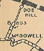
Previous VA 803's:

1932 ROUTE LOG
VA 804: 0 - 0
CR 7: 6.63 - 6.63
GAP IN ROUTE
CR 1: 0 - 6.63
VA 39 EB: 3.93 - 10.56
VA 39 WB: 0.25 - 10.81
CR 1: 7.72 - 18.53
VA 803: Appeared in August 1928 as new primary routing (upgrade to CR 1) running from VA 39 (now US 250) McDowell north 3.72 miles.
In Aug 1929 (CTB), VA 803 was extended 1.5 miles north over CR 1.
In June 1930 (CTB), VA 803 was extended 1.5 more miles north over CR 1.
In December 1930 (CTB), a second piece of VA 803 appeared as an upgrade to CR 8, from VA 804 (now VA 39) Windy Cove north 5.65 miles. See first scan in VA 804 entry.
1929 Official
VA 803 initial route
In June 1931 (CTB), the original piece was extended to Doe Hill and the second piece was extended 1 mile north towards Ft. Lewis.
In July 1932 (CTB), the original piece was extended south 3.93 miles from VA 39 as an upgrade to CR 1.
The April 1932 VDOT Official shows these two pieces numbered as VA 803. However, the July 1932 Bath and Highland County Maps both show VA 803 renumbered as part of VA 804. I also have a 1933 Conoco (Gousha) that shows the same renumbering and the CTB Minutes do not reference a route 803 after July 1932.
Today, the second piece of VA 803 is part of SR 678 as is the piece south of McDowell. McDowell to Doe Hill is SR 654.
VA 804  not currently assigned
Previous VA 804's:

1932 ROUTE LOG
BEGIN VA 804: 0 - 0
VA 828 SB: 6.47 - 9.60
VA 800 SB: 3.13 - 9.60
VA 800 NB: 0.20 - 9.80
VA 804-Y SB: 12.37 - 22.17
CR 7: 6.63 - 28.80
GAP IN ROUTE
CR 1: 0 - 28.80
VA 39 EB: 3.93 - 32.73
VA 39 WB: 0.25 - 32.98
CR 1: 7.72 - 40.70
VA 804: Appeared in August 1928 as a re numbering of part of VA 338 from VA 17 (now VA 42) Millboro Springs west to Warm Springs, then west 5.8 miles as new primary routing (upgrade to CR 4)
In Aug 1929 (CTB), VA 804 was extended 1.5 miles west over CR 4.
In June 1930 (CTB), VA 804 was extended 1 more mile west over CR 4.
In July 1932 (CTB), VA 804 was extended 1.3 more miles west over CR 4.
It appears that in July 1932, VA 804 east end was extended north over VA 803 to Fort Lewis, then after a gap replaced more VA 803 through McDowell to Doe Hill. The 1932 Bath and Highland County Maps both show VA 803 renumbered as part of VA 804. I also have a 1933 Conoco (Gousha) that shows the same renumbering and the CTB Minutes do not reference a route 803 after July 1932.
This apparent extension left a 0.52 mile piece of primary routing between the old south end of VA 803 and VA 17 Millboro Springs. The 1932 Bath County map does not show a number on it. My guess is that it became VA 804-Y.
In July 1933, VA 804 west of Millboro Springs became VA 501 (1933 draft route list had this becoming VA 9) and the part north of Millboro Springs to Doe Hill became VA 269.
Today, the VA 501 piece is part of VA 39 and the two VA 269 pieces are SR 678 and SR 654.
VA 804-Y: I believe this was created in July 1932 as a renumbering of a piece of VA 804. Served as a 0.52 mile cutoff between VA 804 (now VA 39-SR 678 jct) and VA 17 (now VA 39-42 jct).
In July 1933, this became part of VA 501 (now VA 39). The 1933 draft route list had this becoming VA 9.


1931 Official
VA 804 initial route

1933 Conoco
VA 804 extended over VA 803
VA 805  not currently assigned
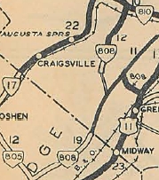
Previous VA 805's:

1932 ROUTE LOG
US 60, VA 14: 0 - 0
VA 805-Y: 9 - 9
VA 808: 12 - 21
US 11, VA 33: 7 - 28
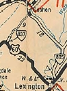
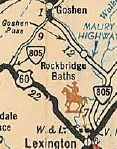
VA 805: Appeared in August 1928 as a re numbering of part of VA 338 from VA 17 (now VA 42) Goshen southeast to US 11/VA 33 (curr SR 750) East Lexington.
In July 1932 (CTB), VA 805's northwest end was extended southwest as an upgrade to CR 2 to California, then replaced VA 837 from there to US 60/VA 14. This left a piece of primary routing no longer part of VA 805 to connect to VA 17 in Goshen. This piece is shown on the 1932 Rockbridge County map but not numbered and probably became VA 805-Y although there is a tiny chance it became VA 837.
In July 1933, VA 805 southeast of Goshen became VA 501 (1933 draft route list had this becoming VA 9) and the part southwest of Goshen became VA 270.
Today, the VA 501 piece is part of VA 39 and a little SR 602/732 in the Rockbridge Baths area; the VA 270 piece is SR 780.
VA 805-Y: I believe this was created in July 1932 as a renumbering of a piece of VA 805. Served as a cutoff between VA 805 (now VA 39-SR 780 jct) and VA 17 (now VA 39-39A-42 jct).
In July 1933, this became part of VA 501 (now VA 39 and 39 ALT). The 1933 draft route list had this becoming VA 9.
1931 Official
VA 805 initial route
1932 Official
VA 805 extended back around to US 60
VA 806  not currently assigned
Previous VA 806's:

1932 ROUTE LOG
US 60, VA 14: 0 - 0
Rockbridge-Alleghany Line: 4.25 - 4.25
US 11, VA 33: 13.30 - 17.55
VA 806: Appeared in August 1928 as an upgrade to CR 12. It ran from US 11/VA 33 (curr SR 764) southwest of Lexington west 8.14 miles towards Collierstown.
In Aug 1929 (CTB), VA 806 was extended west 1 mile.
In June 1930 (CTB), a separate piece of VA 806 was born, running 1 mile east off US 60/VA 14 (now VA 269) Longdale Furnace.
In Dec 1930 (CTB), the two pieces of VA 806 were connected.
In July 1933, VA 806 became VA 251. West of Collierstown is now SR 770.
The SR 770 crossing of North Mountain is little improved since the days of VA 806 and I do not recommend travel without a 4WD.
1932 Official
VA 806
VA 807  not currently assigned
Previous VA 807's:

1928 ROUTE LOG
VA 805: 0 - 0
Augusta-Rockbridge Line: 10.20 - 10.20


1932 ROUTE LOG VA 17: 0 - 0
CR 12: 2.70 - 2.70
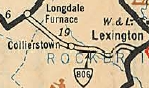
VA 807 #1: Appeared in August 1928 as an upgrade to CR 5 and CR 7, running from VA 805 (now VA 39) Cedar Spring northeast to the Augusta County Line.
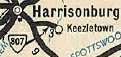
By June 1929, VA 807 was renumbered as part of VA 808. Today it is VA 252.
VA 807 #2: Appeared Dec 1930 (CTB) as an upgrade to secondary routing, running from VA 17 (now Country Club Dr) Harrisonburg east to CR 12 Keezletown.
In July 1933, VA 807 became VA 253 . Today this is SR 925.
VA 807 is the highest primary route number to be used twice.
1928 Official
VA 807 #1.
1932 Official
VA 807 #2.
VA 808  not currently assigned
Previous VA 808's:

1932 ROUTE LOG
VA 805: 0 - 0
Augusta-Rockbridge Line: 10.20 - 10.20
VA 56: 0 - 10.20
GAP IN ROUTE CR 28, CR 33: 0 - 10.20
VA 810: 13.37 - 23.57
VA 808: Appeared in August 1928 in two pieces: 1. US 11/VA 33 near Greenville west to CR Middlebrook (renumbering of small part of VA 251. (see scan in VA 807 entry) 2. Upgrade to CR 2 plus other roads, running from VA 810 (now VA 254) Swoope southwest 11.3 miles to the Summerdean area.
By June 1929, piece 1 was renumbered as part of VA 809. Today it is SR 701.
Also by June 1929, a new southern piece of VA 808 was created as a renumbering of VA 807 from VA 805 (now VA 39) Cedar Grove northeast to the Augusta County line.
In Aug 1929 (CTB), VA 808 northern piece was extended southwest 0.25 more miles.
In June 1930 (CTB), VA 808 northern piece was extended southwest 1.82 more miles to McKinley.
In July 1933, the northern piece of VA 807 became part of VA 56. Today this is SR 876 and SR 602.
The southern piece became part of VA 252.
1929 Official
VA 808 expanded.
VA 809  not currently assigned
Previous VA 809's:

1932 ROUTE LOG
CR 1: 0 - 0
US 11 NB, VA 33 NB: 4.15 - 4.15
US 11 SB, VA 33 SB: 0.84 - 4.99
VA 832: 11.77 - 16.76
VA 39 WB: 3.16 - 19.92
VA 831: 0.5 - 20.42
VA 39 EB: 0.2 - 20.62
Rockingham-Augusta Line: 14.95 - 35.57
VA 17: 9.90 - 44.47
VA 809: Appeared in August 1928 running from US 11/VA 33 near Greenville east to Waynesboro, then north to end at VA 17 (curr SR 996) Montevideo. (renumbering of several parts of VA 251, plus upgrades to Augusta CR 15 and Rockingham CR 13).
By June 1929, VA 809 was extended west to CR 1 near Middlebrook, replacing a piece of VA 808.
In July 1933, VA 809 became part of VA 340. Today this is SR 701 and US 340 to Waynesboro. Leaving today's US 340 in Waynesboro, VA 809 followed Wayne St north to Ohio St west to Florence Ave north to either Bridge Ave or Ash St east to Sherwood Ave which turns into SR 865, heading north to Mt. Meridian, then east along today's VA 256 to Grottoes, but VA 809 used Circle Ln to cross the South River onto 4th St. VA 809 then turned north on 4th Avenue (now SR 825 Dogwood Ave) to go to Port Republic.


1933 Conoco
VA 809
VA 810  not currently assigned
Previous VA 810's:

1932 ROUTE LOG
VA 171: 0 - 0
US 11 NB, VA 33, VA 39: 9.53 - 9.53
VA 810: Appeared in August 1928 as a renumbering of VA 171, running from VA 17 (now VA 42) Buffalo Gap east to US 11, VA 33-39 (now Beverley at Augusta St) Staunton.
In July 1933, VA 810 became part of VA 254.


1929 Official
VA 810
VA 811  not currently assigned
Previous VA 811's:

1932 ROUTE LOG
US 50, US 340 END, VA 36: 0 - 0
US 340 NB, VA 54: 3 - 3
VA 811: Appeared in August 1928 as a renumbering of part of VA 251 running from US 50/VA 36 (now SR 723) Millwood north to VA 54 (now SR 617) Old Chapel.
In July 1933, VA 811 became VA 255.
VA 811 only appeared on the Aug 1928 Official map as it was a full duplex with US 340 its entire lifetime.


1928 Official
VA 811
VA 812  not currently assigned
Previous VA 812's:

1932 ROUTE LOG
VA 17: 0 - 0
US 11, VA 33: 9.47 - 9.47
VA 812: Appeared in August 1928 as an upgrade to CR 23, running from US 11/VA 33 near Weyers Cave west towards VA 17 (now VA 42) near Mossy Creek.
In June 1931 (CTB), VA 812 was extended west 1 mile.
In July 1933, VA 812 became VA 256. Today this is SR 646.
1929 Official
VA 812
VA 813  not currently assigned
Previous VA 813's:

1932 ROUTE LOG
VA 17: 0 - 0
CR 8: 10.98 - 10.98
VA 813: Appeared in August 1928 as an upgrade to CR xx, running from VA 17 (now VA 42 Bus) Dayton west 5.73 miles west towards Ottobine.
In Aug 1929 (CTB), VA 813 was extended west 1 mile.
In Dec 1930 (CTB), VA 813 was extended west another 2.25 miles.
In July 1932 (CTB), VA 813 was extended 2 miles toward the West Virginia line.
In July 1933, VA 813 became part of VA 257.
1929 Official
VA 813
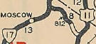
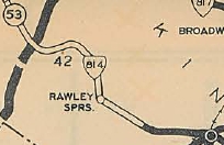
VA 814  not currently assigned
Previous VA 814's:

1932 ROUTE LOG
WV STATE LINE: 0 - 0
VA 17: 21.62 - 21.62
VA 814: Appeared in August 1928 as a renumbering of VA 333 from Harrisonburg to Rawley Springs, plus an upgrade to CR 6 from there to the West Virginia line to meet then-WV 53.
In July 1933, VA 813 became part of VA 4. Today it is US 33.


1929 Official
VA 814
VA 815  not currently assigned
Previous VA 815's:

1932 ROUTE LOG
VA 17: 0 - 0
VA 816: 10 - 10
VA 816: 6 - 16
VA 836: 4 - 20
US 211, VA 21: 8 - 28
VA 841: 2 - 30
VA 37, VA 55: 27 - 57
VA 815: Appeared in August 1928 as a renumbering of part of VA 251 from VA 17 (now US 33 Bus) Elkton north through Luray to 5 miles into Warren County. NOrth of Compton was an upgrade to CR 2.
VA 815 may have briefly used SRs 613, 615, and 615 in the Grove Hill to Alma area, but by 1929 it appears it moved to modern US 340 leaving behind CRs 203, 201, 200).
In Aug 1929 (CTB), a second piece of VA 815 appeared as an upgrade to CR 3, running from VA 37-55 (curr Main St) Front Royal southwest 2 miles.
In Dec 1930 (CTB), the northern piece of VA 815 was extended southwest another 4.02 miles.
About 1931, VA 815 was rebuilt onto modern US 340/340 Bus from Alma to Stanley, leaving behind CR 223 (now SR 636)
In July 1932 (CTB), the two pieces of VA 815 were connected.
In July 1933, VA 815 became part of VA 340. Today it is generally US 340 and US 340 Bus. In Elkton VA 815 actually used Spottswood Ave between Main St and now-US 340. South of Front Royal VA 815 used SR 605 and SR 649 from Karo to Front Royal.
1933 Conoco
VA 816  not currently assigned
Previous VA 816's:

1932 ROUTE LOG
VA 815: 0 - 0
VA 815: 6.65 - 6.65
VA 816: Appeared in August 1928 as upgraded routing, running from VA 815 (now SR 636) Alma south 5.89 miles.
In Aug 1929 (CTB), VA 816 was extended south to VA 815 (now US 340) Grove Hill.
In July 1933, VA 816 became VA 258. Today it is SR 650.
This was the original routing of VA 212 in the early 1920s.

1932 Official
VA 816
VA 817  not currently assigned
Previous VA 817's:

1932 ROUTE LOG
CR 12: 0 - 0
US 11, VA 33: 3.25 - 3.25
VA 818 NB: 4.17 - 7.42
VA 818 SB: 0.72 - 8.12
VA 844: 14.98 - 23.10
WV STATE LINE: 2.41 - 25.51
VA 817: Appeared in August 1928 as a renumbering of VA 332 from US 11-VA 33 Mauzy northwest through Broadway and into West Virginia near Dovesville. The final 7.1 miles were an upgrade to CR 2.
In July 1932, VA 817 was extended east to CR 12 (now SR 620) Althone as an upgrade to CR 3.
In July 1933, VA 817 became VA 259. Today it is SR 608 east of US 11. West of US 11 it is still VA 259 except in Broadway VA 817 used VA 259 ALT.


1929 Official
VA 817
VA 818  not currently assigned
Previous VA 818's:

1932 ROUTE LOG
US 11, VA 33: 0 - 0
VA 817 WB: 12.39 - 12.39
VA 817 EB: 0.72 - 13.11
Shenandoah-Rockingham Line: 5.69 - 18.80
VA 819: 2.95 - 21.75
VA 820: 5.95 - 27.70
VA 824, VA 55: 10.20 - 37.90
VA 818: Appeared in August 1928 as an upgrade to CR 11, running from VA 818 (current VA 259 ALT) north to Timberville (see scan under VA 817).
In Dec 1930 (CTB), VA 818 was extended north to the Shenandoah County Line as new routing, then replaced VA 819 from the county line to Forestville.
Also in Dec 1930, a new piece of VA 818 was created as an upgrade to CR 11 running from US 11-VA 33 Harrisonburg north 1.68 miles.
Also in Dec 1930, a 3rd piece of VA 818 was created as an upgrade to CR 14, running from VA 820 (now VA 263) northeast 2.87 miles.
In June 1931 (CTB), VA 818 was assigned extended from Forestville northwest 2 miles.
In July 1932 (CTB), the 3rd piece of VA 818 was connected to the original piece at Broadway. Also, the 2nd piece was extended north to short of VA 824 (curr SR 675) Columbia Furnace.
In July 1933, VA 818 became VA 260. Today it is generally VA 42. In Harrisonburg VA 818 used Edom Rd. VA 818 also went through Edom; in Broadway, VA 818 used VA 259 ALT east to VA 259 north; in Columbia Furnace VA 818 used SR 767 and SR 623.
1932 Official
VA 818 expanded
VA 819  not currently assigned
Previous VA 819's:

1932 ROUTE LOG
VA 818: 0 - 0
US 11, VA 33: 5.30 - 5.30
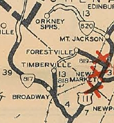
VA 819: Appeared in August 1928 as an upgrade to CR 13, running from US 11-VA 33 near New Market west through Quicksburg to about Forestville. See scan under VA 817.
In Aug 1929 (CTB), VA 819 was extended southwest to the Rockingham County Line.
In Dec 1930 (CTB), VA 819 west was truncated to Forestville, replaced by an extended VA 818. See scan under VA 818.
In July 1933, VA 819 became VA 262. Today it is generally SR 767 but it used SR 827 over the N. Shenandoah River.
VA 820  not currently assigned
Previous VA 820's:

1932 ROUTE LOG
US 11, VA 33: 0 - 0
VA 818: 6.05 - 6.05
VA 845: 4.85 - 10.90
CR 23: 1.90 - 12.80
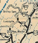
VA 820: Appeared in August 1928, running from US 11-VA 33 Mount Jackson west to about Bayse. Most of this was a renumbering of VA 336 but the last 1.3 miles was an upgrade to CR 2.
In Dec 1930 (CTB), VA 820 was extended to Orkney Springs. See scan under VA 818 entry.
In July 1933, VA 820 became VA 263. In Mount Jackson, VA 820 used Orkney St instead of today's VA 263.
VA 821  not currently assigned
Previous VA 821's:

1932 ROUTE LOG
US 211, VA 21: 0 - 0
CR 15, CR 245: 4.70 - 4.70
VA 821: Appeared in August 1928 as an upgrade to CR 15, running from US 211-VA 21 Luray via Mechanic St. northwest 3.7 miles to the Shenandoah River.
In June 1931 (CTB), VA 821 was extended northwest 1 mile.
Initially, VA 821 met US 211 via Hawsbill St (1932 VDOT County Atlas). The 1936 Page County map shows the primary route meeting US 211 via Lee St.
In July 1933, VA 821 became part of VA 266. Today it is SR 675.
1929 Official
VA 821
VA 822  not currently assigned
Previous VA 822's:

1932 ROUTE LOG
US 50, VA 36: 0 - 0
VA 827: 2 - 2
WV STATE LINE: 22 - 24
VA 822: Appeared in August 1928 running from US 50-VA 36 Winchester northwest to beyond Cross Junction. Some of this was a renumbering of VA 339 while the rest was an upgrade to CR 11.
In Aug 1929 (CTB), VA 822 was extended north 1.2 miles.
In June 1930 (CTB), VA 822 was extended north 2 miles.
In Dec 1930 (CTB), VA 822 was extended north to the West Virginia line.
In July 1933, VA 822 became part of VA 7. Today it is generally US 522, but used SR 789 through Albin; SR 684 through Gainesboro; the SR loop through Cross Junction.
1932 Official
VA 822
VA 823  not currently assigned
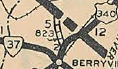
Previous VA 823's:

1932 ROUTE LOG
US 340, VA 37: 0 - 0
WV STATE LINE: 2.90 - 2.90
VA 823: Appeared in August 1928 as new primary routing, running from US 340-VA 37 near Berryville north 2.9 miles to the West Virginia line near Summit Point, WV.
In July 1933, VA 822 became VA 267. Today it is SR 611.


1929 Official
VA 823
VA 824  not currently assigned
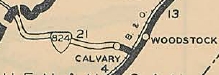
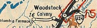
Previous VA 824's:

1932 ROUTE LOG
WV STATE LINE: 0 - 0
VA 818: 12.10 - 12.10
US 11 SB, VA 33 SB: 5.35 - 17.45
US 11 NB, VA 33 NB: 0.85 - 18.30
END VA 824: 6.26 - 24.56
VA 824: Appeared in August 1928 as a renumbering of VA 331, running from US 11-VA 33 south of Woodstock west to the West Virginia line heading for Lost City.
In Dec 1930 (CTB), VA 824 was duplexed with US 11 into Woodstock, then extended east 6.26 miles as an upgrade to CR 7, ending at Forest Rd 4 (Little Fort Rd just across Powell Mtn.)
In July 1933, VA 824 became VA 261.
The route used by VA 824 is from west to east: A 4wd trail from the WV Line south to Forest Rd 252 (the gravel road that currently runs from old WV 59 over to SR 675 was NOT VA 824 but was probably VA 59 later); Forest Rd 252 south to SR 691; SR 691 to Liberty Furnace; SR 717 east to SR 675; SR 675 east to Columbia Furnace; SR 623 and SR 768 over to VA 42; VA 42 east to the I-81 area; Fairground Rd to US 11; US 11 Main St to Court St; Court St east to Water St; Water St north to Cemetery Rd; Cemetery Rd east out of Woodstock, becomes SR 758 which VA 261 followed up the mountain to its endpoint at forest road 108.
1929 Official
VA 824 initial route
1932 Official
VA 824 extended east, and erroneously removed to the west
VA 825  not currently assigned
Previous VA 825's:

1932 ROUTE LOG
US 340, VA 37: 0 - 0
WV STATE LINE: 2.90 - 2.90
VA 825: Appeared in August 1928 as a renumbering of a piece of VA 251, running from VA 54 (now SR 628-658 jct) south to about Greenway Court.
In Aug 1929 (CTB), VA 825 was extended south 0.87 miles.
In July 1932 (CTB), VA 825 was extended south 0.90 miles to Stone Bridge.
In July 1933, VA 825 became part of VA 340. Today it is SR 658.
1929 Official
VA 825

Previous: VA 700 - 728  |  Next: VA 826 - 90005
Top  |  Virginia Hwy Index Home

Page last modified 26 March, 2022