< US 240 | Home | US 258 >
US 250 Business | US 250 ALT
US 50
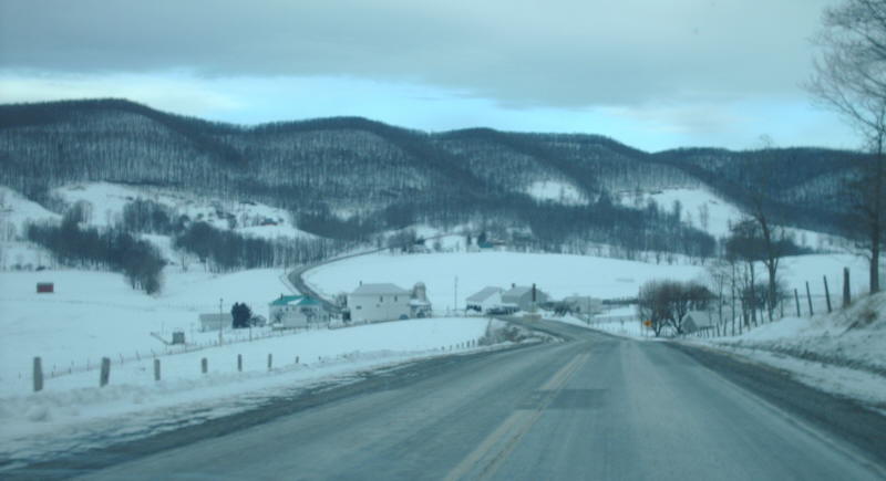
Photo: A wintry landscape along westbound US 250 approaching SR 640 hightown in Highland County (photo by Mapmikey 1/10/10)
| US 250 < US 240 | Home | US 258 > US 250 Business | US 250 ALT US 50 |
Photo: A wintry landscape along westbound US 250 approaching SR 640 hightown in Highland County (photo by Mapmikey 1/10/10) |
| ||||||||||||||
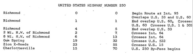
| ROUTE LOG US 360: 0 - 0 I-95 (exit 74): 0.23 - 0.23 US 1, US 301: 1.12 - 1.35 US 33 BEGIN, VA 33: 0.40 - 1.75 VA 399: 1.02 - 2.77 VA 399: 0.05 - 2.82 VA 161: 0.23 - 3.05 VA 197: 0.97 - 4.02 US 33 WB: 0.79 - 4.81 Henrico-Richmond Line: 0.04 - 4.85 I-64 (exit 183): 2.22 - 7.07 VA 157: 3.44 - 10.51 I-64 (exit 178): 2.06 - 12.57 VA 271: 0.84 - 13.41 Goochland-Henrico Line: 2.14 - 15.65 VA 288: 0.28 - 15.93 Louisa-Goochland Line: 14.24 - 30.17 US 522: 1.63 - 31.80 Goochland-Louisa Line: 0.48 - 32.28 Fluvanna-Goochland Line: 12.37 - 44.65 Louisa-Fluvanna Line: 0.13 - 44.78 VA 208: 3.14 - 47.92 US 15: 6.53 - 54.45 Fluvanna-Louisa Line: 0.03 - 54.48 Albemarle-Fluvanna Line: 5.97 - 60.45 VA 22: 4.40 - 64.85 I-64 (exit 124): 2.16 - 67.01 VA 20 NB: 1.64 - 68.65 Charlottesville-Albemarle Line: 0.20 - 68.85 US 250 Bus, VA 20 SB: 0.06 - 68.91 US 29 NB, US 29 Bus: 2.69 - 71.60 Albemarle-Charlottesville Line: 0.35 - 71.95 US 29 SB, US 250 Bus: 1.86 - 73.81 VA 240: 7.09 - 80.90 VA 240: 2.97 - 83.87 I-64 (exit 107): 1.69 - 85.56 VA 151: 4.56 - 90.12 Nelson-Albemarle Line: 1.77 - 90.89 VA 6: 0.13 - 91.02 Augusta-Nelson Line: 1.27 - 92.29 Blue Ridge Pkwy/Skyline Drive: 0 - 92.29 I-64 (exit 99): 0.23 - 92.52 Waynesboro-Augusta Line: 1.76 - 94.28 US 340 NB: 1.44 - 95.72 US 340 SB: 0.19 - 95.91 VA 254: 1.06 - 96.97 US 340: 0.25 - 97.22 Augusta-Waynesboro Line: 1.81 - 99.03 VA 285: 2.17 - 101.20 I-81 (exit 222): 4.52 - 105.72 Staunton-Augusta Line: 0.07 - 105.79 VA 333: 0.25 - 106.04 US 250 Truck, VA 261: 1.15 - 107.19 US 11 SB: 0.75 - 107.94 US 11 NB, US 11 Bus BEGIN, VA 254: 0.07 - 108.01 VA 254: 0.31 - 108.32 US 11 Bus NB: 0.45 - 108.77 US 250 Truck, VA 262: 2.50 - 111.27 Augusta-Staunton Line: 0.04 - 111.31 VA 42 SB: 4.93 - 116.24 VA 42 NB: 0.47 - 116.71 Highland-Augusta Line: 16.52 - 133.23 US 220: 18.69 - 151.92 WV STATE LINE: 13.76 - 165.68 |
Creation: Appeared September 1934 (AASHO) as a renumbering of a large chunk of VA 5 running generally as it does now. It eastern end was at 2nd St at Broad, where it ran into US 60. Note this extension was first identified as worthy in 1931 but WV and VA had to wait until the road west of Monterey VA was put into the state highway system and improved.
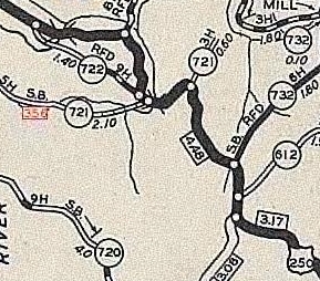
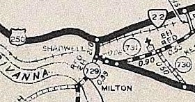
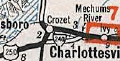
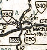
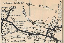
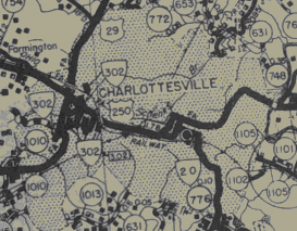
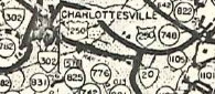
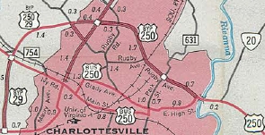
Adjustments: In Oct 1935 (CTB), US 250 was rerouted in Charlottesville. Initially it used Main St, then EB 5th and WB 2nd, Jefferson St, Park St, High St (also partly Free Bridge Rd then). With this change, US 250 used Main St, then EB Water/2nd and WB 1st, High St, Locust Ave, and Watson St/Long Ave (this is now part of the 250 bypass). In Sept 1937 (CTB), US 250 was put on new routing west of Ivy, leaving behind SRs 738 and 739 (now partly SR 786). In 1938, US 250 was rerouted between Churchville and Staunton onto its current path. US 250 originally used the SR 840 loop, then used SR 721 south a bit, crossed Middle River, then used SR 722 north back to current US 250.
There is an undated US route log for Virginia in the AASHO database that must be between 1967-70 that clearly indicates that US 250 ends at I-95 (and US 33 ends at US 360), so it is possible US 250 was extended to I-95 as soon as it was assigned to the turnpike. This might also explain the BGS at I-95 NB Broad St interchange with US 33 both directions and only US 250 westbound.
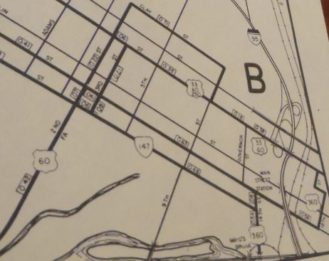
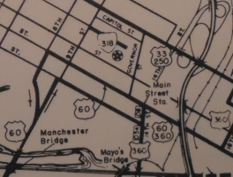
 US 250 shown explicitly ending at I-95 AASHO Route Log late 1960s In June 1974 (CTB), US 250 was extended east along Broad St replacing US 60 to end at 23rd St which is where US 60 WB now left Broad. In Sept 2003 (CTB), US 250 east was truncated to US 360 when US 60 was removed from Broad St altogether.
Improvements: Upon designation, US 250 was paved everywhere except WV Line to Monterey. US 250 was paved west of Monterey in 1939. The first multilaning of US 250 occurred by 1954, on Broad St out to Staples Mill Rd In 1958, 4-laning was extended west to Dickens Rd In 1969, US 250 was 4-laned from US 29 east to just short of US 250 bus/VA 20 when it was placed on the Charlottesville Bypass. In 1970, US 250 was widened from SR 654 Barracks Rd to US 29; Broad St was 4-laned out to Glenside Dr. In 1972, US 250 was 4-laned from US 250 Bus west of Charlottesville halfway to SR 654 Barracks Rd In 1975, US 250 was multilaned the rest of the way between US 250 bus and SR 654. In 1978, US 250 was multilaned around the I-64 Short Pump area In 1979, US 250 Broad St was 4-laned from Glenside Dr to Parham Rd. In 1983 or 1984, US 250 Broad St was 4-laned from Parham Rd to VA 157. In 1988, US 250 was widened from Staunton to Waynesboro In 1992, US 250 was 4-laned from VA 157 west to I-64 Short Pump In 1993, US 250 was 4-laned from I-64 Shadwell west to Locust Ave (Charlottesville Bypass now all 4-laned, even though officials all through the 1970s showed this erroneously). In 1997 or 1998, US 250 was widened from I-64 Short Pump west to the Goochland Line. In 2003, US 250 was multilaned from the Henrico-Goochland Line west to SR 623 US 250 has substantial sections of 6 or more lanes: VA 288 east to downtown Richmond Posted: Fully posted; Staunton cutouts replaced about 2013; Highland County still had a couple sets into 2013 (status unknown); Richmond cutouts went away in mid-2000s. In the late 1990s there was an error VA 250 shield WB leaving VA 157. US 250 is poorly posted east of US 1-301 and back to at least 1981 is not posted east of I-95. Multiplexes: VA 42 (0.47 mi) US 11 Bus (0.76 mi) US 11 (0.07 mi) US 340 (0.19 mi) US 29 (2.21 mi) VA 20 (0.26 mi) US 33 (3.06 mi) Legislative names: The Jefferson Hwy, from Staunton to Shadwell except not Charlottesville Bypass (3/9/22 designation predates US 250); The Woodrow Wilson Pkwy, from ECL Staunton to the Blue Ridge Pkwy (since 2/28/66); Other names: Highland Tpk (Highland Co); Hankey Mtn Hwy (Highland Line to Churchville); Churchville Ave (Churchville to Staunton); Augusta St/Johnson St/Greenville Ave/Richmond Rd (Staunton); Main St/Broad St (Waynesboro); Rockfish Gap Tpk (Blue Ridge Pkwy to Mechum River); Ivy Rd (VA 240 to US 29); Monacan Trail Rd (US 29 duplex); Long St (Charlottesville); Richmond Rd (Albemarle Co east of Charlottesville, Fluvanna Co); Three Notch Rd (w Louisa Co segment); Broad Street Rd (Goochland Co, E Louisa Co segment); Broad St (Henrico Co, Richmond) Scenic Byway: Blue Ridge Pkwy to US 29/250 Bus (12/17/83) Truck Route: A posted truck route for Staunton appeared about 1999. Runs from US 250 along VA 261 to US 11 north to VA 262 west back around to US 250 west of Staunton. It is very well posted. Comment: US 250 is kind of a forgotten highway in most parts of Virginia. It is closely paralleled by I-64 from Staunton to Richmond and west of Staunton runs through pretty unpopulated territory. US 250 is however a wonderful, peaceful drive when not in the cities. West of Staunton it is quite scenic, especially in Highland County. US 250 has several mountain range crossings west of Staunton. The worst is at the Augusta-Highland Line but the others are not all that bad. The crossing at Afton Mtn can actually be driven at 55 mph. VDOT Traffic logs back to at least 2001 say that US 250 is on split streets in downtown Staunton, with WB using New St. However, US 250 is not posted this way in the field. US 250 is misidentified as VA 5 in both the Staunton and Charlottesville insets of the 1936 Official. | |||||||||||||
Previous: US 240 |
Next: US 258
US 50
Top | Virginia Hwy Index
Home
Page last modified 8 March 2022

