< US 25E | Home | US 33 >
US 29 Business | US 29 ALT
US 129
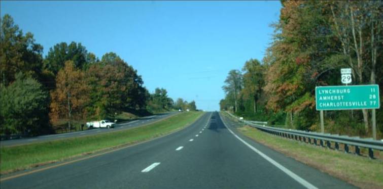
Photo: US 29 in Campbell County (photo by Mapmikey 10/21/10)
|
|
|
| ROUTE LOG |
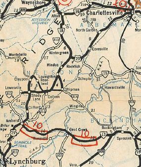
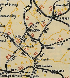
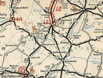
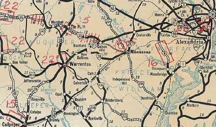
NC STATE LINE: 0 - 0 US 29 Bus, US 58 WB: 0 - 0 VA 86: 3.75 - 3.75 US 58 EB, US 58 Bus, US 360: 3.21 - 6.96 Pittsylvania-Danville Line: 2.00 - 8.96 VA 41: 0.32 - 9.28 US 29 Bus: 6.52 - 15.80 US 29 Bus: 7.46 - 23.26 VA 57: 1.25 - 24.51 US 29 Bus: 2.21 - 26.72 US 29 Bus: 6.17 - 32.89 VA 40: 1.83 - 34.72 US 29 Bus: 2.48 - 37.61 US 29 Bus: 7.16 - 44.77 Campbell-Pittsylvania Line: 3.15 - 47.92 VA 43: 0.72 - 48.64 US 29 Bus: 3.64 - 52.26 VA 24: 9.23 - 61.49 US 29 Bus, US 460 WB: 6.42 - 67.91 Lynchburg-Campbell Line: 0.03 - 67.94 US 501 NB: 1.87 - 69.81 US 460 Bus, US 501 SB, US 501 Bus: 1.91 - 71.72 US 460 EB: 2.14 - 73.86 Campbell-Lynchburg Line: 0 - 73.86 Lynchburg-Campbell Line: 0.93 - 74.79 Amherst-Lynchburg Line: 0.33 - 75.12 VA 210: 1.09 - 76.21 VA 130: 3.77 - 79.98 US 29 Bus: 7.15 - 87.13 US 60: 1.72 - 88.85 US 29 Bus: 1.45 - 90.30 VA 151: 1.99 - 92.29 Nelson-Amherst Line: 4.10 - 96.39 VA 56 WB: 4.47 - 100.86 US 29 Bus, VA 56 EB: 4.28 - 105.14 US 29 Bus: 0.82 - 105.96 VA 6 WB: 6.51 - 112.47 VA 6Y: 0.30 - 112.77 VA 6 EB: 3.64 - 116.41 Albemarle-Nelson Line: 1.44 - 117.85 I-64 (exit 118): 16.75 - 134.60 US 29 Bus: 0.36 - 134.96 US 250 WB, US 250 Bus: 1.52 - 136.48 Charlottesville-Albemarle Line: 1.98 - 138.46 US 29 Bus, US 250 EB: 0.35 - 138.81 Albemarle-Charlottesville Line: 1.70 - 140.51 Greene-Albemarle Line: 8.81 - 149.32 US 33: 3.21 - 152.53 Madison-Greene Line: 3.68 - 156.21 VA 230 WB: 5.57 - 161.78 VA 230 EB, VA 231 SB: 0.52 - 162.30 US 29 Bus, VA 231 NB: 1.34 - 163.64 US 29 Bus: 2.02 - 165.66 Culpeper-Madison Line: 7.19 - 172.85 US 29 Bus, VA 299: 6.44 - 179.29 US 15 SB, US 15 Bus: 1.02 - 180.31 US 522, VA 3: 1.32 - 181.63 US 15 Bus, US 29 Bus: 3.88 - 185.51 US 15 Bus, US 29 Bus: 6.96 - 192.47 Fauquier-Culpeper Line: 0.24 - 192.71 US 15 Bus, US 29 Bus: 2.17 - 194.88 VA 28: 0.30 - 195.18 US 17 SB: 4.00 - 199.18 US 15 Bus, US 17 Bus, US 29 Bus: 4.71 - 203.88 US 17 NB: 2.44 - 206.32 US 15 Bus, US 29 Bus: 0.48 - 206.80 VA 215: 6.22 - 213.02 Prince William-Fauquier Line: 0.13 - 213.15 US 15 NB: 0.82 - 213.97 VA 55: 3.31 - 217.28 I-66 (exit 43): 0.89 - 218.17 VA 234: 3.75 - 221.92 Fairfax-Prince William Line: 1.29 - 223.21 I-66 (exit 52): 3.15 - 226.36 VA 28: 0.86 - 227.22 VA 286: 3.15 - 230.37 Fairfax City-Fairfax Line: 2.24 - 232.61 US 50 WB, VA 236: 0.60 - 233.21 VA 123: 0.96 - 234.17 US 50 EB: 1.66 - 235.83 VA 237 WB: 0.08 - 235.91 Fairfax-Fairfax City Line: 0.13 - 236.04 VA 243: 0.80 - 236.84 I-495 Express: 2.43 - 239.27 Falls Church-Fairfax Line: 1.85 - 241.12 VA 338: 0.53 - 241.65 VA 7: 0.28 - 241.93 Arlington-Falls Church Line: 0.50 - 242.43 VA 237 EB: 0.18 - 242.61 I-66 (exit 69): 0.05 - 242.66 VA 120: 2.11 - 244.77 VA 309 NB: 0.15 - 244.92 VA 309 SB: 0.05 - 244.97 VA 309: 0.67 - 245.64 I-66 (exit 72): 0.50 - 246.14 VA 124: 0.17 - 246.31 DC LINE: 1.57 - 247.88
|
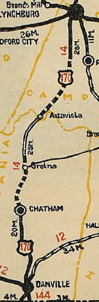
Creation: US 29 is an original US Highway that appeared in Virginia October 1931, running from Danville to Lynchburg as a replacement for US 170 (also attached to VA 14); attached to VA 18 from Lynchburg to Woods Mill; and as an addition to VA 28 from Woods Mill to Culpeper where US 29 ended at US 15-VA 32/37 (now just Fredericksburg Rd) Culpeper. The Lynchburg to Culpeper corridor was part of an approved extension of US 170 then all of US 170 was renumbered as US 29 at the same time.
| US 29's designation in Virginia appears to be a product of the May 1931 CTB agreeing to "...work out a unified system of United States Route Numbers for a road leading from Danville to Warrenton..." A closer look at US 29's original routing:
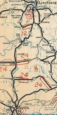
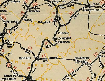
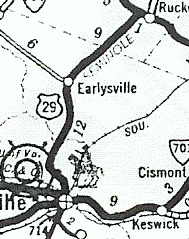
US 29 followed US 29 Bus through Amherst except SR 671 in Monroe and Faulconerville Dr at Faulconerville. North of Amherst, US 29 followed VA 151 then VA 151Y, then VA 56 east back to modern US 29 and 29 Business into Lovingston. From Lovingston, US 29 used SR 770 Cannery Loop but otherwise modern 29 to Woods Mill. US 29 followed VA 6 west then VA 6Y east back to current US 29 which it followed pretty closely to Covesville, using Covesville Ln through the community. Then US 29 followed its current routing to about I-64, then used Teel Ln and on the other side of I-64 picked up SR 702 which becomes US 29 Business. US 29 followed that to Emmet St, then turned right and followed Emmet St to Main St. US 29 went east on Main then north on Rugby out to SR 743 which it followed to US 33.
US 29 used US 33 to SR 645 north back to current US 29 which it followed to Culpeper except used SR 631 Kirtley Rd; Mays Ln; SR 717/643 loop near Reva; US 29 Business into Culpeper.
Adjustments: By 1932, US 29 was placed on current VA 293 north of VA 41 and modern US 29 Business through Blairs. In June 1933 (AASHO), US 29 was extended north with US 15 to Warreton then east with US 211 to Washington DC. Per 1933 AASHO correspondence, the routing of US 29 along US 15 and US 211 was meant to be temporary. An undated letter indicated Virginia was interested in using today's VA 28 from Remington to Manassas; over through Fairfax Station; a yet-to-be built "bypass and direct line around Washington". Alas, none of this occurred and US 29 was put on US 15 and then US 211 with no movement at anytime afterwards.
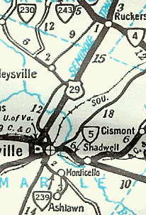
In July 1933, VA 14, VA 18, and VA 28 were dropped from US 29. In Oct 1934 (CTB), US 29 was removed from SR 717/643 loop west of Culpeper. Also in 1934, US 29 was rerouted onto current US 29 Business and US 29 from Main St Charlottesville north past Ruckersville, leaving behind SRs 743/644 (now just 743), VA 4 (now US 33), and SR 645.
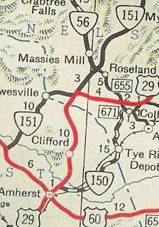
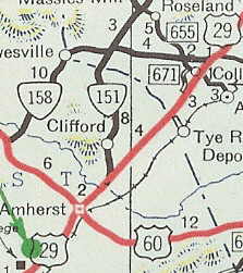
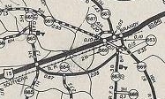
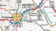
About 1935, US 29 was placed on today's SR 762 between Inlet and Brandy Station. In Oct 1935 (CTB), the first US 29 ALT routing through Danville was created. While US 29 was not deposted, it was removed from the primary system funding list until 1941 when that US 29 ALT was removed and instead assigned to the first Danville bypass. I believe US 29 was removed from SR 770 north of Lovingston in the mid-1930s. About 1937, US 29 was given its original bypass (with US 15) around Warrenton to the west, leaving behind US 15 ALT. It appears that US 29 was put on its modern routings at Leon and Brightwood in March 1938 (CTB), leaving behind SR 647/607 loop; SR 607/678 loop north of Brightwood; SR 631 In Oct 1947 (CTB), US 29 was put on newly constructed routing from Amherst to Colleen, leaving behind VA 151 and VA 158. The new route may have used a tiny bit of VA 150.
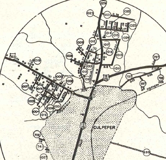
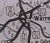
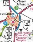
In Dec 1947 (CTB), US 29-211 was removed from the SR 674/693 loop at New Baltimore. In 1948, US 29 was placed on today's US 29 Business north out of Culpeper, leaving behind SR 727 (Piedmont St/Clay St/Old Brandy Rd)
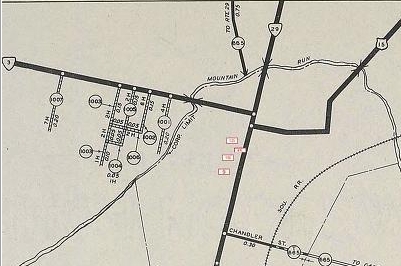
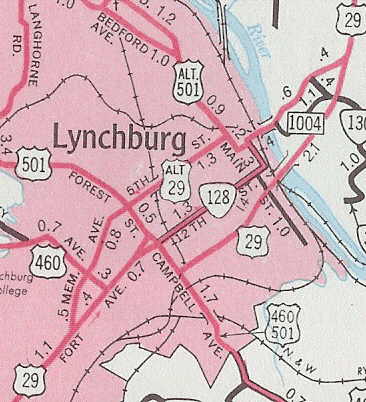
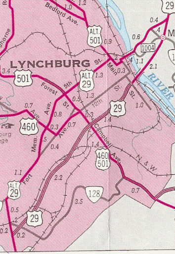
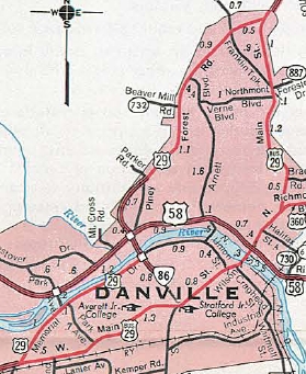
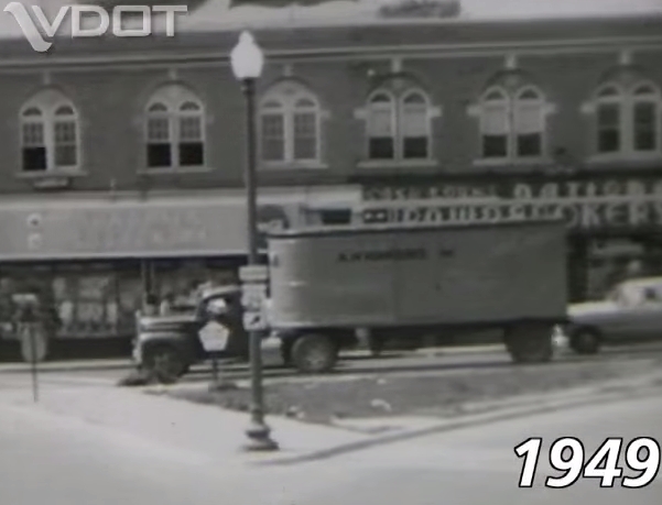
About 1952, US 29 was placed on its current North Carolina crossing, leaving behind SR 657 (now unnumbered) into North Carolina. In Oct 1953 (CTB), US 29 was removed from SR 712 north of Altavista. By 1958 (likely years earler), US 29 was removed from SRs 738 and 754 north of VA 24. In Aug 1955 (CTB), US 29 was rerouted in Lynchburg to continue along Fort Ave, then south on Campbell Ave to the new completed portion of the Lynchburg Expressway, then using the new road across the James River to meet back up with the original route in Madison Heights. The old route through downtown Lynchburg became US 29 ALT (now VA 163). In Sept 1959 (CTB), US 29 was placed on more completed Lynchburg Expressway leaving behind more US 29 ALT (now VA 163).
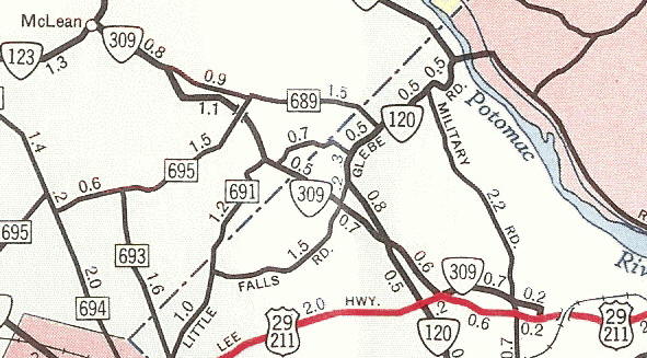
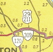
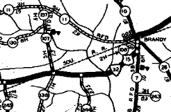
In Jan 1960 (CTB), US 15-29 was removed from SRs 685/676 between Brandy Station and Elkwood. In 1960-61, US 29-211 and VA 309 swapped alignments to today's configuration. US 29-211 had used Lee Hwy all the way through here.
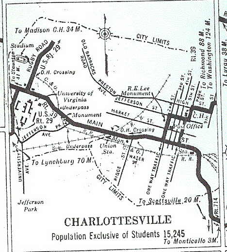
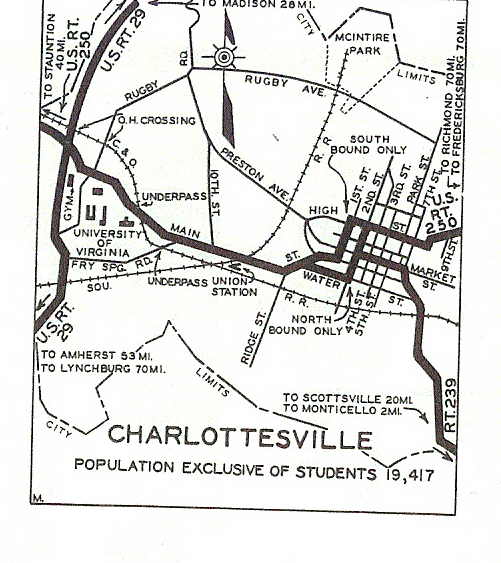
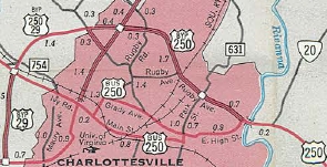
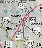
In Jan 1962 (CTB), US 29 was given its bypass of Madison, leaving behind US 29 Business and a part of VA 231. In May 1964 (CTB), the Executive Secretary of Prince William County requested that US 29 be rerouted along VA 28 from Remington to Centreville via Manassas so that Manassas can have a US Route. In July 1966 (AASHO), US 29 was given its bypass of Chatham, leaving behind US 29 Business and part of SR 1429. In Oct 1966 (CTB), US 29 was given its bypass of Charlottesville utilizing new construction plus existing US 250 bypass. This left behind Teel Ln, SR 702, and US 29 Business.
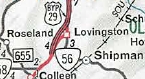
Also about 1966, US 29 was rerouted at Woods Mill to its current routing leaving behind VA 6Y and VA 6 (routes have since swapped). In Sept 1967 (CTB), US 29 was removed from SR 779 in the Red Hill area. In Feb 1969 (CTB), US 29 was given its bypass of Lovingston, leaving behind US 29 Business and a part of VA 56.
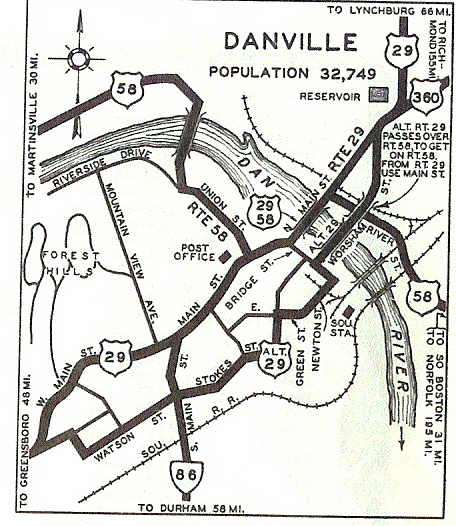
In Nov 1969 (CTB), US 29 was given its bypass of Amherst, leaving behind US 29 Business. In June 1970 (AASHO), US 29 received its bypass of Hurt and Altavista, leaving behind US 29 Business. In Dec 1970 (CTB), US 29 was assigned to what had been the US 29 ALT bypass around the west side of Danville. The route through Danville became US 29 Business (now VA 293). In April 1971 (CTB), US 29 was placed on its Brightwood Bypass leaving behind SR 607/730. About 1971, US 29 was rerouted in Danville off of Piney Forest Rd south of Parker Rd onto new routing across the Dan River, then west on Riverside Dr. The old route had been a US 58 duplex west to Park Ave south across the Dan River. In Aug 1972 (CTB), US 29 was removed from SR 671 in the Five Forks area north of Madison Heights. In May 1974 (CTB), US 29 was removed from SR 988 in Motley. In June 1974 (AASHO), US 29 received its bypass of Gretna, leaving behind US 29 Business. In Nov 1974 (AASHO), US 29 was placed on more completed Lynchburg Expressway south to Wards Rd, leaving behind US 29 Business. Also in Nov 1974 (AASHO), US 29 was given its Culpeper Bypass, leving behind US 15-29 Business. Around 1975, US 15-29 was given its modern routing from Inlet past Brandy Station to Remington, leaving behind OSR 15-29 (now SR 762) and also SRs 685/755. In Sept 1975 (CTB), US 29 was given its bypass of Remington, leaving behind US 15-29 Business.
In June 1978 (CTB), US 29 was removed from Faulconerville Rd. In Dec 1978 (CTB), US 29 was removed from SRs 838 and 841 through Covesville. In July 1980 (CTB), US 211 was removed from US 29. In May 1987 (AASHTO), US 29 was placed on the new freeway bypass of Warrenton around to the east. This left behind US 29 Business.
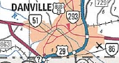
In June 1996 (CTB), US 29 was placed on its bypass around the east and south of Danville using new construction north of US 58 and replacing VA 265 south of US 58.
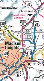
In Oct 2005, US 29 was placed on newly constructed freeway from the south end of the Amherst Bypass to US 460 east of Falwell Airport. US 29 now follows US 460 west to meet back up with US 29 near Lynchburg Airport. The freeway from US 460 to VA 210 opened in Dec 2004. The old route past Sweet Briar College and through Madison Heights became part of a very long US 29 Business.
Improvements: Upon designation in 1931, US 29 was fully paved everywhere except from Ruckersville to the Rapidan River, which was corrected when US 29 moved to modern routing there in 1934. The first multilaning of US 29 occurred between 1941-47, from Fairfax Circle west to the current 2-lane segment of US 29 approaching Manassas Battlefield. In 1954, US 29 was multilaned from about VA 215 to US 15 NB. In 1955, US 29 was multilaned from Charlottesville north a couple miles. In 1956, the 1955 widening was extended to the S. Rivanna River; the 1954 widening was extended west to the east end of the Warrenton Bypass; also from about VA 55 to the east edge of Manassas Battlefield In 1957, US 29 was multilaned from US 15 to VA 55. In 1958, US 29 was multilaned from S. Rivanna River to SR 649. In 1960 or 1961, US 29 was 4-laned from the Bannister River through Chatham; Whittles through Gretna; Lynchburg Expwy south of the James River; VA 120 to VA 124; also incorrectly shown to be 4-laned undivided through Manassas Battlefield (until 1975 issue on insets; 1981 on the main maps). In 1962, US 29 was 4-laned from VA 120 west to VA 237 Falls Church. In 1963, US 29 was multilaned from NC line to today's VA 293; the 1960 widening through Chatham was redrawn to be from SR 718 to the Bannister River and not through Chatham; the 1960 widening from Whittles to Gretna was redrawn to be Whittles south to what is now the north end of the Chatham BYpass. In 1965, US 29 was widended on the new Chatham Bypass; Lynchburg Airport to Lynchburg Expwy; SR 649 north to Greene County; west to the WCL of Falls Church. In 1966, US 29 was multilaned from James River to VA 130; Myndus to Woods Mill; Culpeper south a mile; Opal to the original Warrenton Bypass In 1967, US 29 was multilaned from VA 24 to Lynchburg Airport; north of Lovingston to Myndus; north of SR 692 to US 250 with a small gap south of today's I-64. In 1968, US 29 was multilaned from VA 24 south several miles; Albemarle/Greene Line to south end of Madison Bypass; from VA 28 to Opal. In 1969, US 29 was multilaned from the north end of today's VA 293 to SR 718; VA 130 to Monroe; Lovingston Bypass; north of Brightwood to Culpeper In 1970, US 29 was multilaned on its new US 58 duplex; the 1868 widening was extended south to SR 712. In 1971, US 29 was multilaned from VA 86 to Parker Rd; Monroe to north of VA 151; Madison Bypass north to past Brightwood In 1972, the Monroe widening was extended to Nelson County line; Colleen to Lovingston; Covesville to the north of SR 692. In 1973, US 29 was multilaned from Colleen south to Amherst line; on its new Culpeper Bypass In 1974, US 29 was multilaned from SR 712 south on the bypass of Altavista, Hurt, and Motley. In 1975, US 29 was multilaned on the Gretna bypass; the small gap south of I-64; US 250 duplex; from the Culpeper Bypass to VA 28; Fairfax Circle to Falls Church. In 1977, US 29 was multilaned from VA 6 to Covesville In 1978, US 29 was multilaned from Gretna bypass to Motley. In 1979, US 29 was multilaned on most of its VA 6 duplex In 1980, US 29 was multilaned on the rest of the VA 6 duplex In 1983 or 1984, US 29 was multilaned from Parker Rd to the north end of today's VA 293. In 1998, US 29 was multilaned on its new Danville Bypass routing from the NC Line to US 58-360. In 2005, US 29 was multilaned from US 58 north to US 29 Bus Blairs; the new Madison Heights Bypass plus US 460 duplex were multilaned upon opening. Around 2012, US 29 was 6-laned from VA 286 to Fairfax City WCL In 2016, US 29 was 6-laned from Pickwick Rd to Union Mill Rd east of Centreville. In 2026, US 29 was 6-laned from Union Mill Rd to VA 286. The only 2-lane segment of US 29 remaining is within the Manassas Battlefield Park. US 29 is a full freeway on the bypasses of Danville, Chatham, Gretna, Hurt-Altavista, Lynchburg-Madison Heights-Amherst, Charlottesville, and Warrenton. The Culpeper Bypass is now full freeway with the completion of the SR 666 interchange in fall 2017. US 29 is 6-lanes from the Charlottesville Bypass to SR 743; 8-lanes from SR 743 to SR 643 at the S. Rivanna River; 6 lanes from the S. Rivanna River to SR 649; 6-lanes from I-66 to Fairfax City; 6-lanes from Summit Dr to Legato Rd west of Fairfax City; 6-lanes from Eaton Pl to Fairfax Circle; 6-lanes from I-66 (exit 72) to the DC Line Posted: Fully posted; The only mainline US 29 cutouts thought to be remaining are in Falls Church. The Madison Bypass cutout set was replaced in 2012. A VA 29 shield existed briefly on US 60 WB at the Amherst Bypass but has been corrected. A bonus error - in 2003 I spotted FL 29 shields in Pensacola. There is an erroneous Seminole Trail sign SB near VA 215 which is north of its legislative end in Warrenton. Multiplexes: US 58 (6.96 mi) US 460 (incl. triplex) (5.95 mi) US 460, US 501 (1.91 mi) VA 56 (4.28 mi) VA 6 (3.94 mi) US 250 (2.33 mi) VA 230 (0.52 mi) VA 231 (1.34 mi) US 15 (incl triplex) (32.16 mi) US 15, US 17 (7.14 mi) US 50 (2.62 mi) VA 237 (6.70 mi) VA 309 (0.05 mi)
| |||||||||||||||||||||||||||||||||||||||||


Previous: US 25-E |
Next: US 33
US 29 Business | US 29 ALT
US 129
Top | Virginia Hwy Index
Home
Page last modified 25 June 2026