|
|
|
|
ROUTE LOG
US 29, VA 231 SB: 0 - 0
VA 231 NB: 1.24 - 1.24
US 29: 0.80 - 2.04
|
|
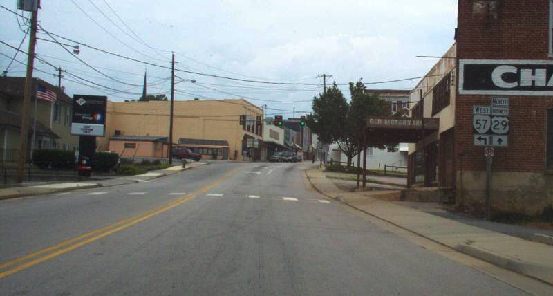
Creation: The 1st US 29 Business appeared Jan 1962 (CTB) when US 29 was given an eastern bypass of Madison CH.
Adjustments: None
Improvements: Paved upon inception; No multilaning
Posted: Fully posted. Cutouts at the VA 231 split removed between 2018-21.
Multiplexes: VA 231 (1.24 mi)
Legislative names: Seminole Trail (2-16-28 designation predates US 29)
Other names: Main St
Scenic Byway: no segments
Comment: None
|
1963 Official |
|
|
|
|
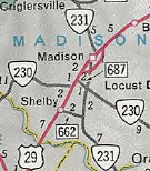
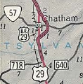
ROUTE LOG
US 29: 0 - 0
VA 57 EB: 1.36 - 1.36
VA 57 WB: 0.19 - 1.55
US 29: 1.98 - 3.53
|
|
Creation: The 2nd US 29 Business appeared in July 1966 (AASHO) when US 29 was given an eastern bypass of Chatham
Adjustments: None
Improvements: Paved upon inception; No multilaning
Posted: Fully posted.
Multiplexes: VA 57 (0.19 mi)
Legislative names: Seminole Trail (2-16-28 designation predates US 29)
Other names: Main St
Scenic Byway: no segments
Comment: south of VA 57 is some lovely residential areas.
|
1966 Official |
|
|
|
|
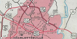
ROUTE LOG
US 29: 0 - 0
Charlottesville-Albemarle Line: 0.37 - 0.37
US 250 Bus: 1.64 - 2.01
US 29, US 250: 1.40 - 3.41
|
|
Creation: The 3rd US 29 Business appeared Oct 1966 (CTB) when US 29 was given a western bypass of Charlottesville
Adjustments: None
Improvements: Paved upon inception; Multilaned on the northernmost half-mile or so.
Posted: Fully posted.
Multiplexes: None
Legislative names: Seminole Trail (2-16-28 designation predates US 29)
Other names: Fontaine Ave, Jefferson Park Rd, Emmet St
Scenic Byway: no segments
Comment: US 29 Business passes right through a large swath of the University of Virginia
|
1970 Official |
|
|
|
|
ROUTE LOG
US 29, VA 56 WB: 0 - 0
VA 56 EB: 0.30 - 0.30
US 29: 0.63 - 0.93
|
|
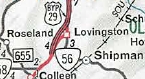
Creation: The 4th US 29 Business appeared Feb 1969 (CTB) when US 29 was given a western bypass of Lovingston
Adjustments: None
Improvements: Paved upon inception; no multilaning
Posted: Fully posted. An error VA 29 Business shield has existed on VA 56 WB
Multiplexes: VA 56 (0.30 mi)
Legislative names: Seminole Trail (2-16-28 designation predates US 29)
Other names: Front St
Scenic Byway: no segments
Comment: This is one of the shortest business routes in Virginia
|
1971 Official |
|
|
|
|
ROUTE LOG
US 29, US 460: 0 - 0
Lynchburg-Campbell Line: 0.31 - 0.31
US 501 NB, VA 163: 1.64 - 1.95
US 501 SB, VA 128: 0.45 - 2.40
US 221, US 460 Bus, US 501 Bus: 1.79 - 4.19
Amherst-Lynchburg Line: 1.24 - 5.43
VA 210: 1.06 - 6.49
VA 163: 0.75 - 7.24
VA 163: 0.25 - 7.49
VA 130: 2.20 - 9.69
US 29: 8.06 - 17.75
US 60: 2.47 - 20.22
US 29: 1.27 - 21.49
|
|
Creation: The 5th US 29 Business appeared Feb 1969 (CTB) when US 29 was given an eastern bypass of Amherst
Adjustments: In Oct 2005, US 29 Business was extended south through Madison Heights and along the Lynchburg Expressway when US 29 was given its current bypass well east of Lynchburg.
Improvements: Paved upon inception; Multilaned everywhere except the original Amherst Business route.
US 29 Business is a full freeway between VA 163 Lynchburg and VA 163 Madison Heights.
Posted: Fully posted.
Multiplexes: US 501 (0.45 mi)
Legislative names: Seminole Trail (2-16-28 designation predates US 29)
Other names: Wards Rd/Lynchburg Expwy (Lynchburg); S. Amherst Hwy (Amherst Co); Main St (Amherst)
Scenic Byway: no segments
Comment: This is one of the longest business routes in Virginia
Prior to its recent rehab to a roundabout, the intersection with US 60 in Amherst was Virginia's oldest traffic circle, dating back to the 1930s.
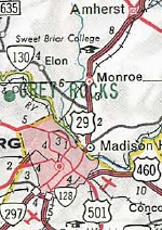
US 29 Business in Amherst
1971 Official
|
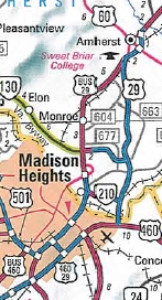
US 29 Business extended south through Lynchburg
2006 Official
|
|

  |
From:     Culpeper (Culpeper County) Culpeper (Culpeper County)
To:
 Inlet (Culpeper County) Inlet (Culpeper County)
Total Length: 5.92 miles
|
|
|
|
|
ROUTE LOG
US 29, VA 299: 0 - 0
US 15 Bus SB, US 522 SB, VA 3: 1.67 - 1.67
US 522 NB: 0.85 - 2.52
VA 229: 0.20 - 2.72
US 15, US 29: 3.20 - 5.92
|
|
Creation: The 8th US 29 Business appeared Nov 1974 (AASHO) as a renumbering of mainline US 29 through Culpeper.
Adjustments: None
Improvements: Paved upon inception; multilane only from VA 229 northeast to Ira Huffman Ln.
Posted: Fully posted; cutouts replaced in mid-2010s.
Multiplexes: US 15 Bus, US 522: (0.85 mi)
US 15 Bus (3.40 mi)
Legislative names: Seminole Trail (2-16-28 designation predates US 29)
Other names: Madison Rd, Main St
Scenic Byway: no segments
Comment: Main St Culpeper is frequently slow and cumbersome to travel.
|
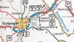
US 29 Bus in Culpeper and Remington
1978 Official
|
|
|
From: Motley (Pittsylvania County)
To:
Altavista (Campbell County)
Total Length: 6.45 miles
|
|
|
|
|
ROUTE LOG
US 29: 0 - 0
Campbell-Pittsylvania Line: 2.83 - 2.83
VA 43: 0.32 - 3.15
US 29: 3.30 - 6.45
|
|
Creation: Designated May 1974 (CTB) as a renumbering of mainline US 29 through Hurt and Altavista. This is the 9th US 29 Business.
Adjustments: None
Improvements: Paved upon inception; multilane within Altavista
Posted: Fully posted
Multiplexes: None
Legislative names: Seminole Trail (2-16-28 designation predates US 29)
Other names: Main St
Scenic Byway: no segments
Comment: US 29 Business uses a 1920s bridge over the James River.
|
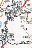
1975 Official |
|
From: Gretna (Pittsylvania County)
To:
Gretna (Pittsylvania County)
Total Length: 4.12 miles
|
|
|
|
|
ROUTE LOG
US 29: 0 - 0
VA 40: 2.65 - 2.65
US 29: 1.47 - 4.12
|
|
Creation: Designated June 1974 (AASHO) as a renumbering of mainline US 29 through Gretna. See scan above. This is the 10th US 29 Business.
Adjustments: None
Improvements: Paved upon inception; multilane on the southernmost half-mile
Posted: Fully posted
Multiplexes: None
Legislative names: Seminole Trail (2-16-28 designation predates US 29)
Other names: Main St
Scenic Byway: no segments
Comment: Gretna has an actual downtown.
|
|
From: near Elkwood (Culpeper County)
To:
near Remington (Fauquier County)
Total Length: 2.71 miles
|
|
|
|
|
ROUTE LOG
US 15, US 29: 0 - 0
Fauquier-Culpeper Line: 0.56 - 0.56
US 15, US 29: 2.15 - 2.71
|
|
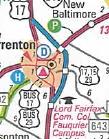
Creation: Designated Sept 1975 (CTB) as a renumbering of mainline US 29 through Remington (see scan above). This is the 11th US 29 Business.
Adjustments: None
Improvements: Paved upon inception; no multilane segments
Posted: Fully posted
Multiplexes: US 15 Bus (entire length)
Legislative names: Seminole Trail (2-16-28 designation predates US 29)
Other names: Remington Rd (Culpeper Co); James Madison Rd (Fauquier Co)
Scenic Byway: no segments
Comment: Remington is a pretty small place for a business route designation. Only interesting thing is the 1930 bridge over the Rappahannock River.
|
|
From:  Warrenton (Fauquier County) Warrenton (Fauquier County)
To:
Warrenton (Fauquier County)
Total Length: 4.92 miles
|
|
|
|
|
ROUTE LOG
US 15, US 15 Bus BEGIN, US 17, US 17 Bus BEGIN US 29: 0 - 0
US 15 Bus NB: 0.89 - 0.89
US 211 WB, US 211 Bus: 1.76 - 2.65
US 17 Bus NB: 0.86 - 3.51
US 15 Bus SB, US 211 Bus: 0.55 - 4.06
US 17: 0.59 - 4.65
US 15, US 15 Bus END, US 29: 0.27 - 4.92
|
|
Creation: Designated May 1987 (AASHTO) as a renumbering of mainline US 29 through Warrenton. This is the 12th US 29 Business.
Adjustments: None
Improvements: Paved upon inception; multilane throughout except from about US 211 south to US 15 Bus
Posted: Fully posted; error VA 29 Business shield at SR 802 for a time
Multiplexes: US 15 Bus, US 17 Bus (0.89 mi)
US 17 Bus (1.76 mi)
US 17 Bus, US 211 (0.86 mi)
US 211 (0.55 mi)
US 15 Bus (0.86 mi)
Legislative names: Seminole Trail (2-16-28 designation predates US 29)
Other names: James Madison Hwy, Shirley Ave, Broadview Ave, Lee Hwy
Scenic Byway: no segments
Comment: US 29 Business uses the original 1930s Warrenton Bypass.
|
2002 Official
|
|
|
From: North Carolina State Line (City of Danvile)
To:
Blairs (Pittsylvania County)
Total Length: 14.16 miles
|
|
|
|
|
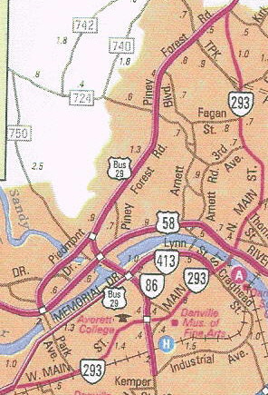
ROUTE LOG
NC STATE LINE: 0 - 0
US 58: 0.10 - 0.10
VA 293: 2.33- 2.43
VA 86 SB, VA 413: 2.60 - 5.03
US 58 Bus: 0.30 - 5.33
VA 86 END: 0.97 - 6.30
VA 41: 2.41 - 8.71
VA 293: 0.44 - 9.15
Pittsylvania-Danville Line: 0.13 - 9.28
US 29: 4.88 - 14.16
|
|
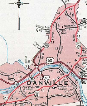
Creation: Designated June 1996 (CTB) as a renumbering of mainline US 29's western bypass of Danville. This is the 13th US 29 Business. See scan under US 29 Bus #7 immediately below.
Adjustments: None
Improvements: Paved upon inception; multilane throughout
Posted: Fully posted;
Multiplexes: VA 86 (0.97 mi)
Legislative names: Seminole Trail (2-16-28 designation predates US 29)
Other names: W. Main St, Memorial Dr, Central Blvd, Piney Forest Rd, N. Main St
Scenic Byway: no segments
Comment: US 29 Business does technically enter North Carolina for 0.18 miles, which is maintained by VDOT.
|
| Previous US 29 Business's:
1998 ROUTE LOG
US 29: 0 - 0
VA 86: 2.36 - 2.36
VA 413: 0.91 - 3.27
US 58, US 360, BEGIN VA 360: 0.22 - 3.49
VA 360 EB: 0.70 - 4.19
VA 41: 1.79 - 5.98
US 29: 0.91 - 6.89
2007 ROUTE LOG
US 29, US 501: 0 - 0
VA 128: 0.44 - 0.44
US 460 Bus WB: 0.42 - 0.86
US 460 Bus EB: 1.19 - 2.05
US 221: 0.60 - 2.65
US 501 Bus: 0.80 - 3.45
Amherst-Lynchburg Line: 1.65 - 5.10
VA 210: 0.72 - 5.82
US 29: 0.49 - 6.41
US 29: 0.43 - 6.84
|
|
US 29 Business #7: Appeared Dec 1970 (CTB), as a renumbering of mainline US 29 through central Danville. US 29 Business followed W. Main St and N. Main St.
US 29 Business was renumbered as VA 293 in June 1996 (CTB).
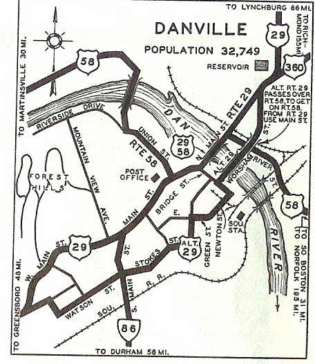 US 29 on Main St, Danville
1941-42 Official
|
 US 29 Bus replaces US 29 through Danville
1941-42 Official
|
 VA 293 replaces US 29 Bus through Danville
1998 Official
|
US 29 Business #8: Appeared about 1971 as a renumbering of US 29 ALT through Lynchburg. US 29 Business followed Memorial Dr, 5th St, Main St, then crossed the James River at 7th St before ending at US 29 in Madison Heights.
In 1988, the James River crossing was moved to use 5th instead of Main to 7th.
In Oct 2005, US 29 Business was renumbered as VA 163.
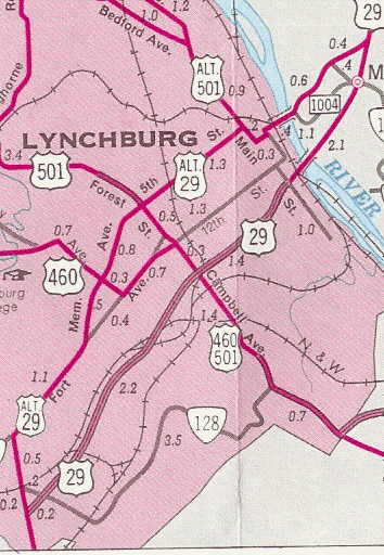
US 29 ALT through Lynchburg
1961 Official
|
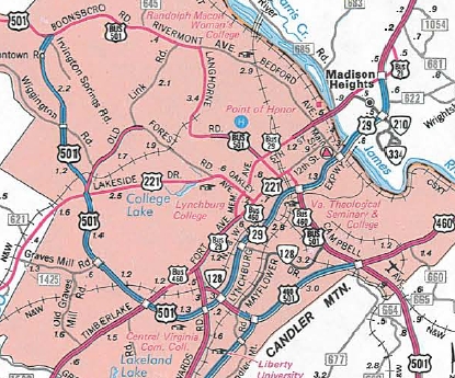
US 29 Bus through Lynchburg
1990 Official
|
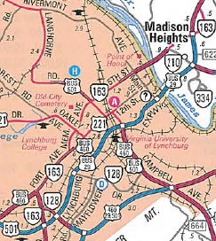
VA 163 replaces US 29 Bus
2006 Official
|
|
Previous: < US 25E | Next: US 33
>
US 29 | US 29 ALT
Top | Virginia Hwy Index
Home
Page last modified
4 February 2022
| | | | | | | | | |