< I-87 | Home | I-99 >
I-195 | I-295 | I-395 | I-495 | I-595 | I-795 | I-895
Photo: A scan from the 1973 Rand McNally approaching the mixing bowl southbound on I-95 before it was changed to I-395 (courtesy Douglas Kerr)
|
|
|
| ROUTE LOG |
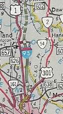
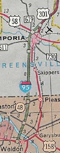
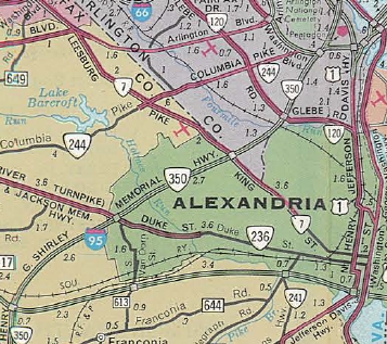
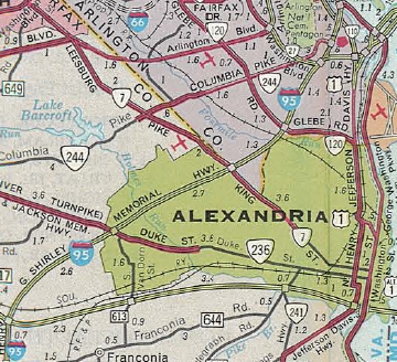
NC STATE LINE: 0 - 0 EXIT 4 (old 1) - SR 629: 4.13 - 4.13 EXIT 8 (old 2) - US 301: 4.12 - 8.25 Emporia-Greensville Line: 1.70 - 9.95 EXIT 11 (old 3) - US 58: 1.05 - 11.00 Greensville-Emporia Line: 0.62 -11.62 [NB only] EXIT 12 (old 4) - US 301: 1.37 - 12.99 EXIT 13 (old 5) - SR 614: 0.52 - 13.51 Sussex-Greensville Line: 3.63 - 17.14 EXIT 17 (old 6) - US 301: 0.16 - 17.30 EXIT 20 (old 7) - SR 631: 2.95 - 20.25 EXIT 24 (old 8) - SR 645: 4.04 - 24.29 EXIT 31 (old 9) - VA 40: 6.63 - 30.92 EXIT 33 (old 10) - SR 602: 2.46 - 33.38 Prince George-Sussex Line: 1.37 - 34.75 EXIT 37 (old 11) - SR 623: 2.41 - 37.16 EXIT 41 (old 12) - US 301, VA 35, VA 156: 3.73 - 40.89 EXIT 45 (old 13) - US 301: 4.54 - 45.43 EXIT 46 - I-295 (exit 1): 1.11 - 46.54 EXIT 47 (old 14) - SR 629: 0.30 - 46.84 Petersburg-Prince George Line: 0 - 46.84 EXIT 48 (old 15) - US 460 EB: 1.15 - 47.99 EXIT 50 (old 16) - US 301: 2.79 - 50.78 EXIT 51 (old 17, old 2) - I-85 (exit 68), US 460 WB: 0.03 - 50.81 EXIT 52 (old 3) - US 301, US 460 Bus, VA 36: 0.44 - 51.25 Colonial Heights-Petersburg Line: 0.64 - 51.89 EXIT 53 (old 3A) - South Park Blvd: 0.21 - 52.10 EXIT 54 (old 4) - VA 144: 0.98 - 53.08 Chesterfield-Colonial Heights Line: 2.38 - 55.46 EXIT 58 (old 5) - SR 620: 1.55 - 57.01 EXIT 61 (old 6-EW, old 6) - VA 10: 2.90 - 59.91 EXIT 62 (old 6) - VA 288: 1.81 - 61.72 EXIT 64 (old 6A) - SR 613: 2.04 - 63.76 EXIT 67 (old 7) - VA 150, VA 895: 2.77 - 66.53 Richmond-Chesterfield Line: 0.80 - 67.33 EXIT 69 (old 8) - VA 161: 1.12 - 68.45 EXIT 73 (old 9) - Maury St: 3.81 - 72.26 EXIT 74A (old 9A) - VA 195: 0.85 - 73.11 [SB only] EXIT 74B (old 10A) - Bank St: 0.31 - 73.42 EXIT 74C (old 10) - US 250: 0.31 - 73.73 EXIT 75 (old 11) - I-64 EB (exit 190): 0.92 - 74.65 [NB only] EXIT 76A (old 12) - US 1, US 301: 0.30 - 74.95 [SB only] EXIT 76B (old 13) - VA 33: 0.24 - 75.19 EXIT 78 (old 14) - VA 161: 1.97 - 77.16 EXIT 79 (old 15A) - I-64 WB (exit 187), I-195: 0.78 - 77.94 Henrico-Richmond Line: 1.07 - 79.01 [NB only] EXIT 80 (old 15) - VA 161: 0 - 79.01 [NB only] EXIT 81 (old 16) - US 1: 0.91 - 80.92 EXIT 82 (old 17) - US 301, VA 2: 0.30 - 81.22 EXIT 83 (old 35) - VA 73: 1.82 - 83.04 EXIT 84 (old 36) - I-295 (exit 43): 1.47 - 84.51 Hanover-Henrico Line: 1.94 - 86.45 EXIT 86 (old 37) - SR 656: 0.95 - 87.40 EXIT 89 (old 38) - SR 802: 1.79 - 89.19 EXIT 92 (old 39) - VA 54: 2.65 - 91.84 EXIT 98 (old 40) - VA 30: 6.01 - 97.85 Caroline-Hanover Line: 3.36 - 101.21 EXIT 104 (old 41) - VA 207: 3.07 - 104.28 EXIT 110 (old 42) - SR 639: 6.12 - 110.40 Spotsylvania-Caroline Line: 6.35 - 116.75 EXIT 118 (old 43) - SR 606: 1.61 - 118.36 EXIT 126 (old 44) - US 1, US 17 SB: 7.58 - 125.94 Fredericksburg-Spotsylvania Line: 2.81 - 128.75 EXIT 130 (old 45) - VA 3: 0.89 - 129.64 Stafford-Fredericksburg Line: 2.29 - 131.93 EXIT 133 (old 46) - US 17 NB, US 17 Bus: 1.25 - 133.18 EXIT 136 - SR 8900: 2.53 - 135.71 EXIT 140 (old 47) - SR 630: 4.22 - 139.93 EXIT 143 (old 48) - SR 610: 2.90 - 142.83 Prince William-Stafford Line: 4.84 - 147.67 EXIT 148 (old 49) - Russell Rd (MCB-1): 0.08 - 147.75 EXIT 150 (old 50) - SR 619: 2.32 - 150.07 EXIT 152 (old 51) - VA 234: 2.39 - 152.46 EXIT 156 (old 52) - SR 784: 3.55 - 156.01 EXIT 158 - VA 294: 2.22 - 158.23 EXIT 160 (old 53) - VA 123: 1.92 - 160.15 Fairfax-Prince William Line: 0.74 - 160.89 EXIT 161 (old 54) - US 1: 0.38 - 161.27 EXIT 163 (old 55) - SR 642: 2.49 - 163.76 EXIT 166 (old 56) - VA 286: 2.69 - 166.45 [SB only] EXIT 167 - SR 617: 1.17 - 167.62 EXIT 169 (old 57) - SR 644: 1.53 - 169.15 EXIT 170 (old 58, old 4) - I-395 (exit 1), I-495 WB (exit 57): 0.96 - 170.11 EXIT 173 (old 3) - SR 613: 1.96 - 172.07 EXIT 174 (old 3A) - Eisenhower Connector: 1.54 - 173.61 EXIT 176 (old 2) - VA 241: 1.55 - 175.16 Alexandria-Fairfax Line: 1.26 - 176.42 EXIT 177 (old 1) - US 1, VA 400: 0.25 - 176.67 WASH DC LINE: 1.07 - 177.74
|
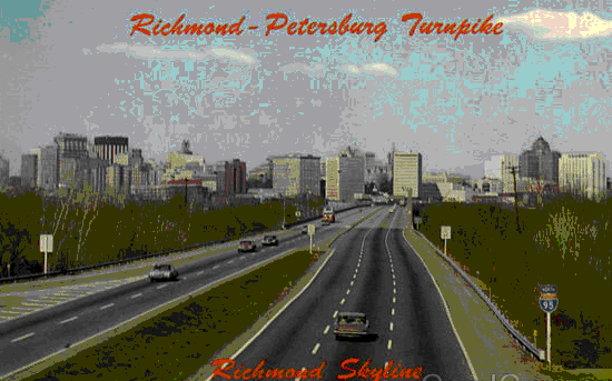
Creation: The first pieces of I-95 to exist were: US 1 Woodbridge to the 14th St Bridge (had been built as VA 350 in the 40's-50's) and the Richmond-Petersburg Turnpike from I-85 to US 301-VA 2, completed in 1958.
|
Adjustments: Many of the following completion dates come from Scott Kozel's website.
In Sep 1959, I-95 opened between the two US 301 exits surrounding Emporia. In Oct 1961, I-95 opened from VA 35 north to the next US 301 exit. In Oct 1962, I-95 opened from I-85 south to US 301 to connect with the Oct 1961 segment. In Feb 1963, I-95 opened from US 301/VA 2 north to VA 54 Ashland. In June 1963, I-95 opened from South Emporia to the North Carolina border
In May 1977 (CTB), the portion of I-95 on the Richmond-Petersburg tpk was placed into the primary system. Operational authority for the Turnpike was transferred to VDOT in June 1973. In June 1980, I-95 was opened from VA 35 south to SR 631 Jarrett. Much of the SB lanes were built on top of the US 301 NB lanes. In mid-1982, I-95 was opened from SR 631 south one exit to US 301. In Sept 1982, I-95 was finally finished in Virginia when it opened from the north end of the Emporia Bypass to US 301 south of Jarrett.
Improvements: Upon designation (per 1959 topo), I-95 was 6-laned from Maury St north to VA 161 Hermitage Rd. Also, I-95 was 6-laned on its VA 350 addition from VA 27 north to DC. The 1963 extension north had I-95 6-laned from Maury St all the way to VA 54. The mid-60s openings from SR 619 Triangle and SR 634 (now SR 784) Dale City were 6-laned. The 1968 Topo shows I-95 as just 4-laned from Dale City across the Occoquan River. In 1969, per Scott Kozel's detailed article, a reversible busway was opened from Springfield to DC. Some of this was just one lane.
The 1971 Topo shows I-95 as 6-laned from Dale City north to at least the Beltway. By the time I-95 was removed from inside the Beltway, it was 6-laned to VA 236 and 8-laned north of that. In Dec 1973 (Kozel), the busway was converted to an HOV-4 (!) facility. Between 1974-78 (Kozel), I-95 was 6-laned from Maury St south to I-85 Petersburg. In 1977 (Kozel), I-95 was widened to 8 lanes on the Beltway from I-395/495 to US 1 Alexandria. In 1980-81, I-95 was widened to 6 lanes from VA 54 Ashland to SR 619 Triangle. In Oct 1988 (CTB), the HOV lane requirements dropped from 4 persons to 3. Between 1988-94, I-95 was 6-laned from Maury St south to I-85 Petersburg. In Nov 1994 (Kozel), the reversible HOV lanes were extended to just south of Newington. In June 1995 (Kozel), the reversible HOV lanes were extended to the Occoquan River. In Jan 1996 (Kozel), the reversible HOV lanes were extended to the SR 2000 Opitz Blvd area in Dale City. In 1996, I-95 was widened to 8 lanes from the Beltway south to about today's VA 286 Newington. In June 1997 (Kozel), the reversible HOV lanes were extended to Quantico Creek south of VA 234 Dumfries. In Dec 2008, I-95 was widened to 10 lanes from west of VA 241 to across the Potomac River, by introducing a separated 2-lane roadway in each direction that serves as "Thru" lanes, while 3 "Local" lanes to the outside also exist. All lanes are able to be used for through traffic - the EB Thru lanes have no exits in Virginia but can be accessed from US 1 and from Eisenhower Ave (via Mill Rd) and the WB Thru lanes have an exit for Eisenhower Ave via Mill Rd and can be accessed from US 1. Froggie has some photos of this area at this link. In June 2011, I-95 was widened to 8 lanes from VA 123 Woodbridge to VA 286. On Dec 15, 2014, a reversible roadway extension south to near SR 610 Garrisonville was opened. The existing HOV lanes were widened to 3 lanes from VA 294 Dale City north to just past SR 648 Edsall Rd. On Dec 29, 2014, the HOV lanes were converted to HOoT (High Occupancy or Toll) lanes, whereby HOV-3 with an EZ-Pass Flex could still use the lanes for free and non-HOV qualifiers could use the lanes and pay a toll via EZ-Pass. Toll rates are done via congestion pricing over several segments. On Oct 31, 2017, the HOoT lanes were extended south 2 miles to the south side of Exit 143 SR 610 in Garrisonville. In Dec 2021, I-95 SB was reconfigured into local and free express lanes from north of Exit 133 (US 17-17 Bus) to south of Exit 130 (VA 3) In August 2023, the HOoT lanes were extended south another 10 miles to tie into the local/express lanes set up at Fredericksburg. With the improvements from Fredericksburg northward, interchanges have been rebuilt: US 17; SR 630; VA 234; VA 123; SR 644; I-395/495 New Exits Added: I-295 north of Richmond (1980) Wagner Rd - now US 460 (1989) Ivey Ave Colonial Heights (1989) VA 288 Chesterfield (1989) I-295 south of Petersburg (1992) Eisenhower Connector Alexandria (1998) SR 656 Hanover County (2004) - interchange at today's SR 835 very nearby was removed SR 8900 Stafford County (2005) VDOT has expressed interest in adding interchanges with VA 208 and VA 289. Posted: Fully posted; A fair number of state-named shields remain, mostly in the Fredericksburg area. The last state-named shield on I-95 itself was SB after VA 40 and was removed (GMSV) between May 2012 and Aug 2013. Multiplexes: US 460 (2.82 mi) I-64 (3.29 mi) US 17 (7.24 mi) I-495 (7.63 mi) Legislative names: Purple Heart Trail, entire route (since 3-8-96); Henry G. Shirley Memorial Hwy, Exit 161 to Beltway (3-20-42 designation predates I-95); Capital Beltway, I-395 to DC Line (4-21-60 designation predates I-95) Jose M Cavazos Memroial Bridge (SR 784 overpass Dale City), since 9-18-97; Purple Heart Bridge over Occoquan River, since 3-7-91; Veterans of Foreign Wars Bridge (VA 289 overpass), since 3-19-93 Other names: None Scenic Byway: No segments HOoT Lane Exits:
Comments: When the I-295 Richmond Beltway was redesigned to also bypass Petersburg in the mid 1970s, the plan also included building an interstate freeway west from the current south end of I-295 to I-85. Then I-85 would be re-routed onto this new freeway segment. Current I-85 north to Petersburg would have become I-385. I-295 would become I-95 and the original I-95 north to Petersburg would become I-795. I-385 and I-795 would have ended at the same interchange while the Richmond-Petersburg Tpk became a state route up to I-64 in Richmond. Although project numbers for I-295's completion heading southward all referenced I-95, when the new freeway reached I-95 it was continued to be signed as I-295. Virginia never did build the freeway segment west back to I-85 and I have not seen any maps showing I-85 on dotted lines. I-95 is one of the busiest roads in America and could use more widening north of Richmond. I-95 blows off the following primary routes in its travels: US 60, VA 33, VA 197, VA 208, VA 289 (on mainline 95), VA 400 I-95 is featured on the cover of the 1959 Official (interchange with US 58), the 1965 Official (NC State Line), and also the 1966 Official in Stafford County The tolls of the Richmond-Petersburg Tpk were removed in 1992 when I-295 was completed. This surely must be true: from 1977 until the exit renumbering in 1992, I-95 in Virginia had to be the only route in the country to use the same exit number three times in one state. You had Exit 2 (US 301 south of Emporia), Exit 2 (I-85) on the Richmond-Petersburg Turnpike, and Exit 2 (VA 241) on the Capital Beltway; There was Exit 3 (US 58 Emporia), Exit 3 (Downtown Petersburg) on the Richmond-Petersburg Tpk., and Exit 3 (SR 613 Van Dorn St.) on the Capital Beltway; Finally, there was also Exit 4 (US 301 north of Emporia), Exit 4 (Colonial Heights), and Exit 4 (I-395/495) on the Capital Beltway. I-95 is erroneoulsly labeled on the 1959 topo to include the part that I-85 occupies. However, there is an Apr 1960 CTB item that also refers to the US 1 Dinwiddie County interchange with the Richmond-Petersburg Tpk as being with "Route 95" - was 95 briefly signed over to US 1? Originally, the BGSs in the HOV lanes north of SR 644 were black instead of green. These signs made it to the late 1980s at least. | ||||||||||||||||||||||||||

Previous: I-87 |
Next: I-99
I-195 | I-295 | I-395 | I-495 | I-595 | I-795 | I-895
Top | Virginia Hwy Index
Home
Page last modified 15 December 2023