<US 570 | Home | US 611 >
US 1 | US 201 | US 301 | US 401 | US 501 | US 701
US 601 at US Ends.com
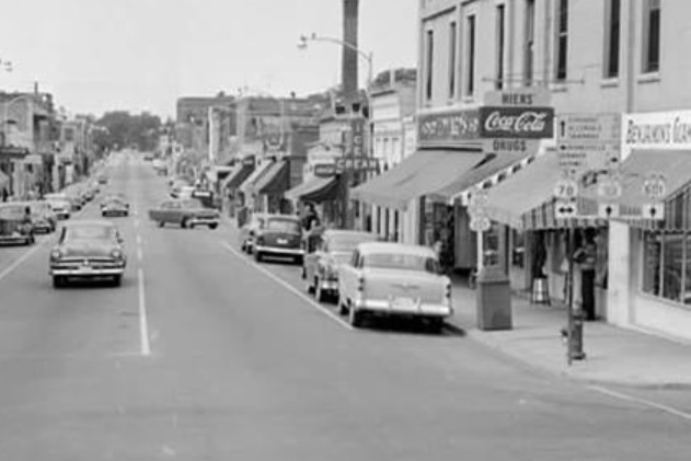
Photo: Early 1950s photo of US 301-601 at US 78 in Bamberg SC... (Facebook)
|
|
|
| ROUTE LOG |
US 321: 0 - 0 US 278 EB: 23.6 - 23.6 US 278 WB: 0.6 - 24.2 US 301 SB: 31.1 - 55.3 US 178 Bus: 17.8 - 73.1 US 21 Bus SB, US 301 NB: 0.6 - 73.7 US 21, US 21 Bus END, US 178: 1.2 - 74.9 I-26 (Exit 145): 3.9 - 78.8 US 176: 6.2 - 85.0 US 76, US 378: 26.5 - 111.5 I-20 (Exit 92): 17.6 - 129.1 US 1 SB: 2.3 - 131.4 US 1 NB, US 521 SB: 5.2 - 136.6 US 521 Bus, US 601 Bus Kershaw: 20.9 - 157.5 US 521 NB: 0.7 - 158.2 US 521 Bus, US 601 Bus: 0.1 - 158.3 NC STATE LINE: 23.7 - 182.0 US 74 EB: 12.4 - 194.4 US 74 WB: 2.6 - 197.0 US 74 Byp: 2.1 - 199.1 US 29 SB: 29.9 - 229.0 I-85 SB (Exit 58), US 29 NB: 3.6 - 232.6 I-85 NB (Exit 75): 16.6 - 249.2 US 29, US 70 EB: 1.2 - 250.4 US 70 WB: 3.1 - 253.5 US 64 EB, US 158: 15.8 - 269.3 US 64 WB: 1.2 - 270.5 I-40 (Exit 170): 1.7 - 272.2 US 421: 14.7 - 286.9 US 601 Bus Dobson: 19.2 - 306.1 US 601 Bus: 2.8 - 308.9 I-74 (Exit 11): 4.5 - 313.4 US 52: 2.4 - 315.8
|
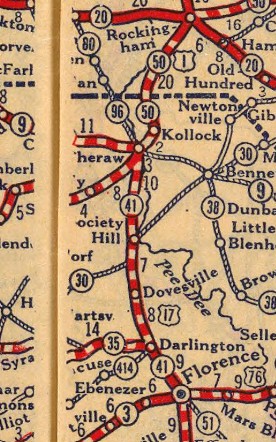
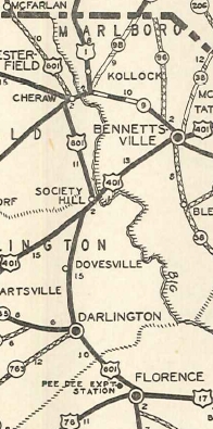
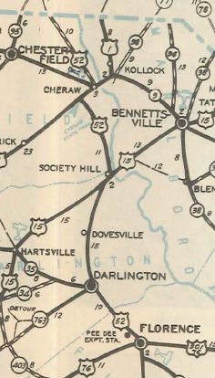
Creation: Created in August 1926 (AASHO) as a renumbering of part of US 17 over SC 41 from Florence SC to US 1 Cheraw SC. The original length reported to AASHO was 39 miles. This means it is very likely US 601 ended in Cheraw where US 1 turned at Church St to go over its original Pee Dee River bridge instead of ending where it met US 1 (now S-13-148 Cash Rd) a couple miles southeast of town. The Florence endpoint was either where it met US 17 (Irby at Cheves) or one block south where US 76 came in from the west on Palmetto.
|
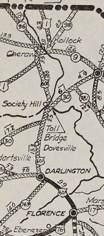
Adjustments: In 1931, US 1 was given its modern routing between Patrick and Cheraw, and US 601 was moved to meet it 2 miles southwest of Cheraw. This left behind S-13-494 Juniper Rd and S-13-148 Cash Rd. US 601's north ending might have become its junction with US 1 (today's US 1-52 split) or it could've ended where it did before just from the opposite direction, or it could've ended where it now intersected 2nd and Market. In March 1932 (AASHO), South Carolina requested a new US route that would run from Raleigh NC to Savannah GA by way of Bennettsville, Sumter and Walterboro. AASHO asked South Carolina to instead extend US 601 from Florence to Sumter (with US 76), then southward to Walterboro and beyond. After much consideration and consultations with both North Carolina and AASHO, South Carolina did not request US 601 extend south but in May 1932 requested US 601 be extended north replacing SC 96 to NC, then follow NC 80 through Wadesville, Salisbury, and Mocksville to end at US 121 (now just Main St) Mt. Airy. This was approved in June 1932. In 1932 (bridge date), US 601 was removed from Creek Crossing Dr and Pine Log Cir (no longer crosses Black Creek) below Dovesville SC. An undated 1934 excerpt from the South Carolina Highway Department showed a directive to request US 601 be extended south replacing US 17 to Charleston. In September 1934 (AASHO), US 601 south was truncated to US 29 Salisbury NC. The route to Florence became part of US 52. It remains so except: Cheves St/Coit St in central Florence SC; US 52 Bus through Darlington SC; S-13-62 Rocky Hill Rd/Brocks Mill Rd above Cheraw; Old Route 80 north of Morven NC; Morven-Morgan-Greene-Caswell-Salisbury through Wadesboro; Pinkston-River Rd above Cedar Hill NC; Riverside Rd and Pee Dee St between Rocky River NC and Norwood; SR 1837 and US 52 Bus through Albemarle NC; Glenmore Rd/Old Route 80 between Misenheimer NC and Gold Hill With US 601 reduced to just 73 miles, AASHO mistakenly believed North Carolina had decommissioned it. When they noticed it was still on maps later, they tried to get North Carolina to decommission but they declined.
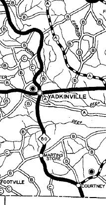
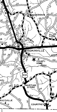
In 1936, US 601 was removed from SR 1502/1503 Country Club Rd north of Yadkinville NC. In 1937 or 1938, US 601 was removed from Pleasant Acre Dr in southern Davie County NC. Also in this timeframe, US 601 was removed from SR 1002 Liberty Church Rd and SR 1332 Elmore Rd loop in northern Davie County. Also in 1937 or 1938, US 601 was removed from a bit of NC 801; SR 1425 Four Corners Rd; SR 1725 Ray Moore Rd to Courtney; SR 1001 Courtney Rd; SR 1165 Fish Brandon Rd to Martins Store; SR 1002 Lone Hickory Rd.
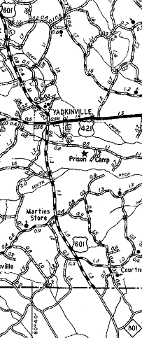
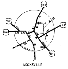
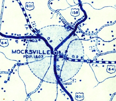
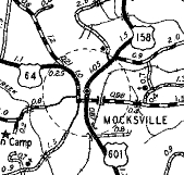
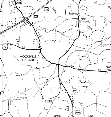
Also in 1937 or 1938, US 601 was rerouted in Mocksville NC to leave Main St via Depot St to Salisbury St instead of using Gaither St to Salisbury St. The portion of Main St between Depot and Gaither Sts became an extended US 158.
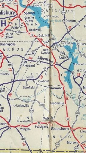
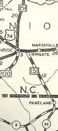
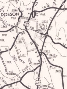
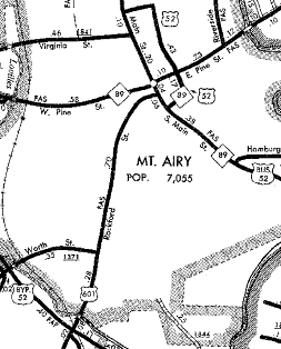
Between 1939-44, US 601 was removed from SR 1135 McCullough Rd south of Mocksville. Also between 1939-44, US 601 was removed from SR 1104 Cody Tr south of Dobson NC and from SR 1355 Mason Rd/2216 Fireside Ln loops in the Turner Mountain area near White Plains. Between 1945-49, US 601 was rerouted in Mocksville to leave Main St via Sanford Ave to Salisbury St instead of using Depot St to Salisbury St. The portion of Main St between Sanford and Depot Sts became an extended US 158. Also between 1945-49, US 601 was removed from SR 1365/2001 Forrest Dr loops just south of today's US 52 Mt. Airy Bypass. In September 1950 (AASHO), US 601 was extended south with US 29 to Concord NC, then replaced NC 151 through Monroe to SC
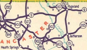
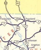
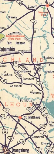
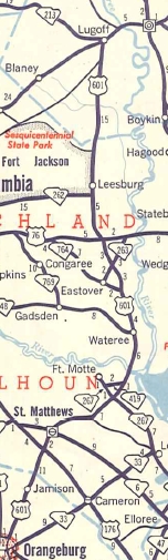
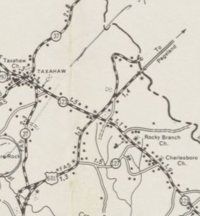
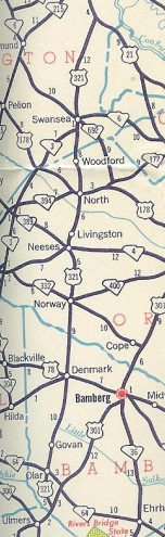
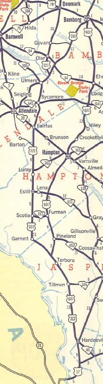
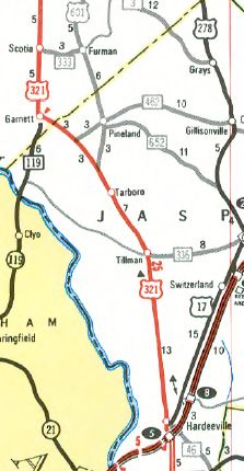
US 601 then replaced SC 151 to Pageland; after a small duplex with SC 9 it replaced SC 902 and part of SC 265 to Kershaw; duplexed with US 521 to Camden and US 1 to Lugoff; replaced SC 26 to Orangeburg; duplexed with US 301 to Bamberg; replaced SC 36 through Pineland; duplexed with US 321 to end at US 17 Hardeeville SC. This added 270 miles to US 601.
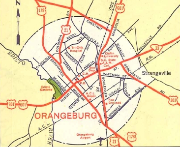
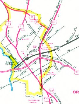
In 1954, US 601 was rerouted in Orangeburg to its current routing by staying on Magnolia a little further. Russell St became an extended SC 33.
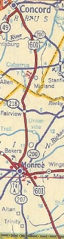
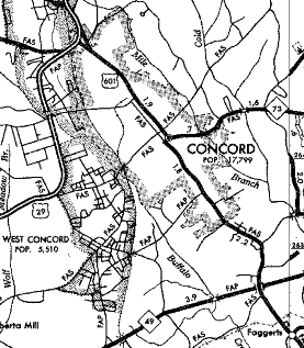
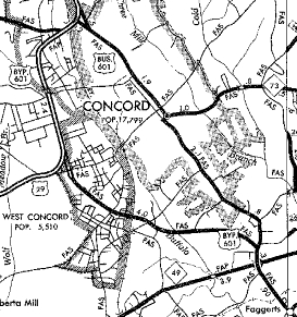
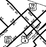
About 1953, US 601 was rerouted in Salisbury to use Fulton St and Liberty St to get from innis to Main. Around 1954, US 601 was again rerouted in Salisbury onto one-way splits: NB left Main St by going south on Bank St then east on Lee St then north on Innis. SB left Innis on Church St west to Fisher St south to Main. The old route using Fulton/Liberty became US 601 Truck while US 601's NB routing replaced a US 29-A routing. Between 1954-57, US 601 was removed from SR 1150 Old Monroe Cir and SR 2631 Fairbluff Rd south of Faggerts NC. In Oct 1965 (NCDOT), US 601 was placed on new construction south of Concord NC, then added to US 29 around the west of Concord. The old route through Concord became US 601 Business (today this is a bit of NC 3; S. Union St, and NC 73).
In 1965 (bridge date), US 601 was removed from Wintertide Dr and S-13-823 in the Lynches River area. The 1922 bridge over the river is still accessible.
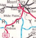
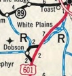
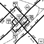
In Sept 1970 (NCDOT), US 601 was placed on new construction bypassing Dobson NC and White Plains to nearly Mt. Airy. This left behind US 601 Business and a lengthy Old US 601.
In Oct 1970 (NCDOT), US 601 was given split routing in Mt. Airy. NB went south on Main then east on Cherry to end at US 52 Bus in Renfro. SB began by leaving Renfro along Pine St then south on Main St to Rockford. In December 1971 (AASHO), US 601 south was extended along US 17 to nearby I-95. In November 1975 (AASHTO), US 601 south was truncated to US 321 below Pineland. The route to Hardeeville remains US 321.
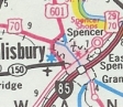
In May 1981 (NCDOT), US 601 was removed from central Salisbury NC and placed onto Jake Alexander Blvd from US 29 northward. Main St remained US 29 and Innis St along with the split alignments all became non-primary.
In Jan 1988 (NCDOT), US 601 was removed from US 29 between NC 152 and Salisbury and instead was added to the I-85 Connector and I-85 north to Jake Alexander Blvd, then along Jake Alexander Blvd north to the existing Salisbury bypass. In Jan 1991 (NCDOT), US 601 was removed from Salisbury St, Wilkesboro St, and Yadkin Rd in Mocksville and moved to the Valley Rd alignment around the west of central Mocksville. The old streets all became secondary.
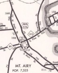
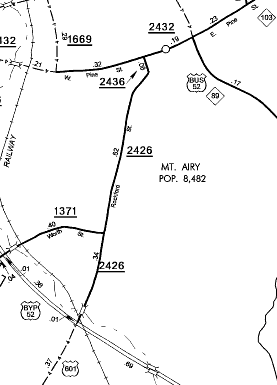
Sometime after 1991, US 601 appears to have been placed on US 521's bypass of Kershaw, then used S-29-62 Hilton St to get back to US 601's orginal route. Hampton St became a posted US 601 Business. Note that SCDOT maps do not show this despite it being heavily posted this way. In March 1995 (NCDOT), US 601's one-way splits were removed in Mt. Airy. US 601 left Rockford via Dixie St north to NC 89 Pine St then east to what had been the US 601 SB beginning at US 52 Business Renfro. All of what had been the NB split became secondary. In May 1996 (NCDOT), US 601 was removed from US 29 between North Concord and China Grove and instead routed onto more I-85. In June 1999 (NCDOT), US 601 north was truncated to the US 52 Bypass of Mt. Airy leaving behind secondary routing.
Comments: Like US 701, US 601 is not a major corridor anywhere. | |||||||||||||||||||||||||||||||||||||||||||
Previous: US 570 | Next: US 611
US 1 | US 201 | US 301 | US 401 | US 501 | US 701
US 601 at US Ends.com
Page last modified 3 February 2026