< TN 72 | Home | TN 73 Scenic | TN 74 >
|
|
|
| ROUTE LOG |
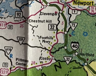
I-40 (exit 364), US 321 Begin, TN 95 NB: 0 - 0 US 70, TN 1: 3.8 - 3.8 I-75 (exit 81): 0.9 - 4.7 US 11, TN 2: 2.6 - 7.3 TN 444: 1.9 - 9.2 TN 95 SB: 3.6 - 12.8 Blount-Loudon Line: 2.1 - 14.9 TN 333: 3.1 - 18.0 TN 335 SB: 4.5 - 22.5 TN 335 NB: 0.6 - 23.1 TN 446: 2.1 - 25.2 US 129, TN 115: 0.2 - 25.4 US 411, TN 33: 1.1 - 26.5 TN 336: 0.2 - 26.7 TN 447: 0.7 - 27.4 Foothills Pkwy: 9.9 - 37.3 TN 73 Scenic, TN 337: 7.4 - 44.7 Sevier-Blount Line: 3.9 - 48.6 Foothills Pkwy: 2.7 - 51.3 US 441 NB, TN 71 NB: 8.4 - 59.7 TN 449: 2.2 - 61.9 US 441 SB, TN 71 SB: 6.3 - 68.2 TN 454: 5.3 - 73.5 TN 416: 1.0 - 74.5 Cocke-Sevier Line: 8.8 - 83.3 TN 32 SB: 3.1 - 86.4 Foothills Pkwy: 1.8 - 88.2 TN 339: 0.2 - 88.4 US 321 NB, TN 32 NB: 5.6 - 94.0 I-40 (exit 440): 2.3 - 96.3 US 25, US 70, TN 9: 6.8 - 103.1
|
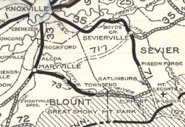
Creation: Appeared in 1927 or 1928 running from TN 33 Maryville to TN 71 (now US 441) below Gatlinburg. This is the 2nd TN 73.
| Adjustments: In 1939, TN 73 was removed from Tuckaleechee Pike east out of Maryville. In 1939 or 1940, TN 73 was extended from Maryville to US 11-70 Knoxville, replacing TN 33A. In 1950, TN 73 was extended with TN 71 to Gatlinburg, then extended east to end at TN 32 below Cosby.
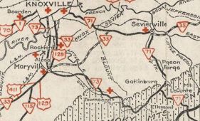
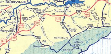
In 1954, TN 73 was removed from the lengthy Old Walland Hwy between Hubbard and Townsend and placed on new routing on the other side of Little River; also removed from W Old Hwy 73/River Rd (used to all connect) through Townsend. Between 1944-56, TN 73 was put on new alignment at Fighting Creek Gap within GSMNP to no longer follow Fighting Creek. In 1956, TN 73 was placed on its modern routing east out of Gatlinburg. This left behind Old Hills Cr Rd, Hills Cr Rd, current TN 416, Webb Cr Rd; Volunteer Rd; E Scenic Dr; Rocky Grove Rd; Apple tree Ln/Ledford Rd/Indian Camp Ck Rd In 1958 (bridge date), TN 73 was placed on Hall Rd north of Broadway. Previously, TN 73 used Broadway east to Everett to Aluminum to Lincoln west to Rankin which used to curl northeast to Hall at Davies St. About 1961, US 129 was added to TN 73 from Maryville to Knoxville. Between 1957-63, TN 73 was placed on the current approach to Newfound Gap Rd south of the Park HQ. Up to then it ran to the north of the HQ and met US 441 on its curve very near Park Headquarters Road. In 1966, TN 73 was extended with US 129 from US 11-70 to I-40. Around 1980, TN 73 was extended north from Cosby then east to I-40 at Exit 440. In 1981, US 321 was added to TN 73 from Maryville to Cosby. At this time, TN 73 was rerouted at Townsend to instead head northeast to Pigeon Forge, then follow US 441 back to Gatlinburg to pick up the previous route. From Townsend to the Great Smoky Mountain NP boundary became TN 73 Scenic (now also TN 337) and is Old State Hwy 73 through the park to Newfound Gap Rd/US 441. About 1982, TN 73 was rerouted at Maryville to instead replace TN 95 while following US 321 to its endpoint at I-40. TN 73 from Maryville to Knoxville became part of TN 115 with the route through Maryville becoming part of TN 35. In 1983, TN 73 was extended from I-40 to US 25-70 east of Newport.
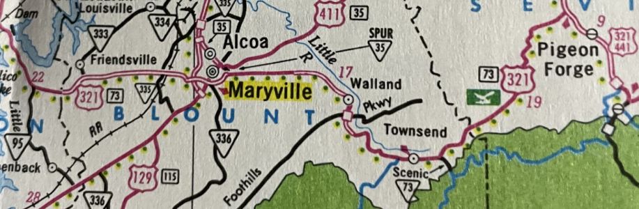
About 1984, TN 73 was removed from White Wing Rd and straightened out east of I-40 near Lenoir City. In 1985, TN 73 was rerouted onto the new Lamar Alexander Pkwy in Maryville. S. Washington St became TN 35 Spur (now TN 447) and Broadway Ave remained part of US 411. Posting: Posted as secondary from US 321/TN 32 to US 25/70. The entirety of the primary portion is unposted Secret US Route Overlay: US 321 (94.0 mi) Comment: TN 73 runs near the northern edge of Smoky Mountain Nat'l Park for many miles, centered around the resorts of Pigeon Forge and Gatlinburg. | Previous TN 73's:
|
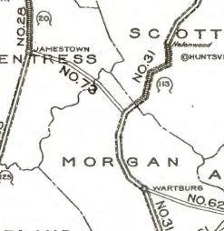
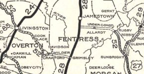
TN 73 #1: An original state highway which in 1924 ran from TN 28 (now US 127) below Jamestown southeast to TN 31 (likely Old Burrville Rd) near Sunbright.
In 1927 or 1928, TN 73 was renumbered as part of TN 52. Today this is TN 296 and TN 52 except: Old Rugby Pike and abandoned Clear Fork bridge, then abandoned alignment to Brooks Cir at Rugby Pike, then Rugby Pike south to Brewstertown Rd to Burrville Rd to Sunbright.
| |||||||||||||