< TN 51 | Home | TN 53 >
|
|
|
| ROUTE LOG |
TN 49: 0 - 0 I-65 (exit 117): 6.8 - 6.8 US 31W, TN 41: 0.5 - 7.3 Sumner-Robertson Line: 0 - 7.3 TN 109: 4.6 - 11.9 TN 259: 7.6 - 19.5 TN 174: 0.1 - 19.6 US 31E, US 231, TN 6: 8.2 - 27.8 Macon-Sumner Line: 1.0 - 28.8 TN 141: 3.1 - 31.9 TN 10: 8.8 - 40.7 TN 261: 0.7 - 41.4 TN 262: 3.9 - 45.3 TN 56: 7.3 - 52.6 TN 151: 1.2 - 53.8 Clay-Macon Line: 2.9 - 56.7 TN 135: 6.6 - 63.3 TN 51: 5.0 - 68.3 TN 53: 8.0 - 76.3 Overton-Clay Line: 6.0 - 82.3 TN 136: 1.5 - 83.8 TN 111: 8.6 - 92.4 TN 85 WB: 0.9 - 93.3 TN 294: 0.9 - 94.2 TN 85 EB: 8.3 - 102.5 Pickett-Overton Line: 4.3 - 106.8 Fentress-Pickett Line: 2.3 - 109.1 TN 154: 11.1 - 120.2 US 127, TN 28: 2.4 - 122.6 TN 296: 4.2 - 126.8 Morgan-Fentress Line: 10.2 - 137.0 Scott-Morgan Line: 2.8 - 139.8 US 27, TN 29: 5.1 - 144.9
|
Creation: Appeared in 1923 as an original state highway, running from TN 25 (now Main St) Hartsville north to Lafayette, then eastthrough Celina to TN 24 (now TN 85) Livingston.
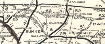
| Adjustments: In 1927 or 1928, TN 52 was extended in both directions: TN 52 west was rerouted at Lafayette to continue west as new routing through Westmoreland to today's US 31W near Portland, then replaced TN 75 end at TN 49 Orlinda. The old route from Lafayette to Hartsville became part of TN 51 (today this is Broadway, Halltown Rd and New Harmony Rd)
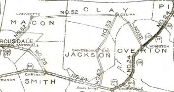
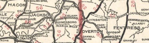
TN 52 east was extended southeast to Grimsley, then north with TN 28 to south of Jamestown, then east and southeast replacing TN 73 to end at US 27 Sunbright.
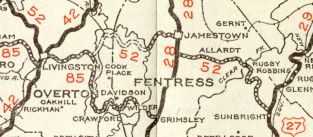
In 1930, TN 52 was rerouted at Livingston to follow TN 24 (now TN 294) north, then east as new state highway to TN 28 Jamestown, then south to where TN 52 headed east to Sunbright. The route from Livingston to Grimsley became TN 85 (still TN 85 today except TN 52 used Old Wilder Rd at the Ober River and Old Grimsley Rd near TN 28) and TN 28 remained north towards Jamestown (now US 127 except TN 52 used Roanoke Rd near the airport). Also in 1930, TN 52 was rerouted at Moss to head ESE to Celina. Up to then, TN 52 used Moss-Arcot Rd through Richville and Arcott to the former Bennetts Ferry across the Cumberland River to connect with TN 53 (no public road east of river anymore) 3.3 miles southwest of Celina, roughly 0.6 miles south of County Rd In 1931 or 1932, TN 52 was changed in Livingston to follow its old path east with TN 85 to east of Alpine, then as new routing to Jamestown.
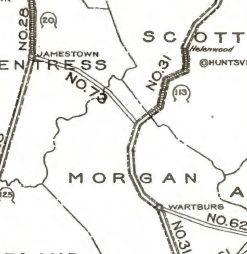
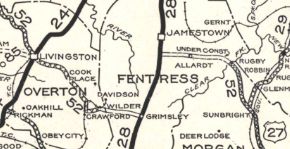
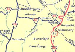
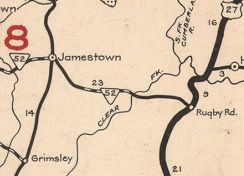
In 1935 or 1936, TN 52 was rerouted at Red Cliff in northern Morgan County to continue east as new state highway to US 27 Rugby Road (now Elgin). The old route to Sunbright was Brewstertown Rd and Burrville Rd. If TN 52 ever used Gum Branch Rd/Sheep Branch Rd it stopped doing so by 1939. In 1939, TN 52 was removed from TN 135/Old Union Hill Rd Between 1941-43, TN 52 was rerouted at Jamestown to head directly southeast to Allardt. This removed TN 52 from its TN 28 overlay (now mostly Main St and York Hwy) and what is now TN 296.
Between 1940-51, TN 52 was removed from Old Rugby Pike west of Elgin. In the early 1950s (by 1955), TN 52 was removed from Hilltop Rd and Hermitage Church Rd (no longer connects to)/Harve Knight Rd at Hermitage Springs; also from Old 52 Loop east of Moss. The one-way splits in Livingston using Broad St WB and Main St EB (original TN 52) may have been in place as early as the mid-1950s. In 1964, TN 52 was removed from Old 52 Loop east of Neely Crossroads; Rhoten Ln at the Clay/Overton line In 1965, TN 52 was removed from Reed St/W. McGlothlin St to instead use College all the way to TN 109, then used TN 109 to E. McGlothlin Also about 1965, TN 52 was removed from Old Hwy 52 west of Neely Crossroads. In 1967, TN 52 was given its current routing east of I-65 towards Portland, leaving behind E. Old Hwy 52, a US 31W overlay and Old Hwy 52 W. In 1971, TN 52 was striaghtened out from Corinth to Oak Grove east of Portland. This left behind: two Old Hwy 52 loops east of Leah Rd; Old hwy 52 #4/Butler Bridge Rd in Corinth; Old Hwy 52 Loop #5; abandoned routing/Martin Rd Also in 1971, TN 52 was straightened out west of Westmoreland, leaving behind Old Hwy 52 Ct near Liberty; Old Hwy 52 #6 in Liberty; Old Hwy 52 #7 In 1972, TN 52 was removed from King Hill rd and Whitaker Cir west of Red Boiling Springs Sometime in the 1970s, TN 52 was straightened out through Handleyton west of I-65, leaving behind a little Stark Rd and abandoned wavy alignments on both sides of TN 52. In 1974, TN 52 was removed from E. McGlothlin, Russell and Old Westmoreland Rd in Portland to instead use TN 109 south to the current TN 52 alignment east out oif Portland. In 1975, TN 52 was rerouted in Celina to leave Mitchell St at Brown St to meet the new TN 53 routing. Between 1974-76, TN 52 was removed from Church St/Red Boiling Springs Rd through Lafayette; About 1980, TN 52 was removed from Timothy Rd through Timothy; Fletcher Cir; Thompson Cir/Old Celina Rd through Allons; Old Allons Rd; a bit of Fairview Ln In 1982, TN 52 was removed from the lengthy Old Hwy 52 through Gap of the Ridge and Sullivan; Brattontown Cir west of Lafayette. In 1992, TN 52 was removed from Austin Peay Hwy and Old Hwy 52 #8 through Westmoreland; Old Hwy 52 through Shiloh, Eulia and Cross Lanes In 1995, TN 52 was removed from Red Boiling Springs Rd through Webbtown, Pike Hollow and Drapers Crossroads In 1995 or 1996, TN 52 was removed from College St west out of Portland and its TN 109 overlay. Between 1998-2006, TN 52 was removed from Oak Grove Church Rd at Oak Grove. In 1999, TN 52 was removed from Old SR 52 at Clear Fork River; anbandoned bridge; footpath that connects to Rugby Pkwy at Brooks Cir. TN 52 was placed on Brewstertown Rd north to connect back with TN 52 Rugby Pkwy Between 1999-2002, TN 52 was removed from Old Clay County Hwy west of Celina. In 2002, TN 52 was placed on its Red Boiling Springs Bypass, leaving behind TN 56 and Celina Rd. In 2014, TN 52 was removed from its TN 53 overlay and the lengthy Old Livingston Hwy to nearly Overton County. Also about 2014, TN 52 was removed from Rugby Pkwy through Red Cliff and Rugby. Posting: Posted as secondary routing only from Orlinda to I-65; posted as primary everywhere else. Secret US Route Overlay: None Comment: TN 52 from Celina to Livingston is part of ADHS Corridor J Overall, TN 52 has been highly improved across most of its routing across the top of Tennessee | |||||||||||||
Previous: TN 51 |
Next: TN 53
Top | Tennessee Hwy Index
Home
Page last modified 2 January 2021