< TN 70 | Home | TN 72 >
|
|
|
|
| ROUTE LOG |
NC STATE LINE: 0 - 0 Begin US 441: 14.2 - 14.2 US 321 NB, TN 73 EB: 0.9 - 15.1 TN 449: 6.3 - 21.4 US 321 SB, TN 73 WB: 2.2 - 23.6 US 411 NB, TN 35 NB, TN 66: 4.7 - 28.3 US 411 SB, TN 35 SB TN 338: 12.5 - 40.8 Blount-Sevier Line: 1.9 - 42.7 Knox-Blount Line: 0.5 - 43.2 TN 168: 3.1 - 46.3 TN 33 SB: 5.0 - 51.3 TN 62: 1.8 - 53.1 TN 33 CONN: 1.6 - 54.7 I-640 (exit 6), US 25W, TN 9: 2.3 - 57.0 TN 331: 0.2 - 57.2 TN 33 NB, TN 131 NB: 4.5 - 61.7 TN 131 SB: 0.4 - 62.1 TN 170 SB: 4.8 - 66.9 Anderson-Knox Line: 1.2 - 68.1 TN 170 NB: 1.7 - 69.8 TN 61 NB: 3.1 - 72.9 TN 61 SB: 0.2 - 73.1 Campbell-Anderson Line: 5.3 - 78.4 Anderson-Campbell Line: 0.8 - 79.2 Campbell-Anderson Line: 0.3 - 79.5 Anderson-Campbell Line: 0.2 - 79.7 Campbell-Anderson Line: 1.3 - 81.0 Anderson-Campbell Line: 1.3 - 82.3 I-75 (exit 128): 0.8 - 83.1 US 25W, US 441 END, TN 9, TN 116: 0.4 - 83.5
|
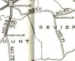
Creation: An original state highway that in 1924 ran from TN 65 (now Park Rd/Eastgate intersection) Sevierville through Gatlinburg to North Carolina at Indian Gap.
| Adjustments: In 1927 or 1928, TN 71 was extended west from Sevierville to TN 33 (now TN 35) Maryville.
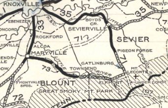
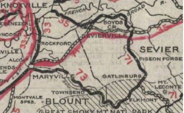
In 1932, TN 71 was rerouted from Indian Gap to Newfound Gap 2 miles to the east. The original road followed the Road Prong from the current Chimney Tops Trailhead area south then near the state line headed east to where Indian Gap is. About 1935, TN 71 was given a more direct route from Sevierville to Maryville. The original route used today's Kilby St (no longer crosses river), Old Knoxville Hwy and TN 338 southwest to Seymour. In 1935, Tennessee tried to get US 25 ALT assigned to TN 71 from Sevierville through Smoky Mtn National Park. In 1939 or 1940, TN 71 and TN 35 swapped places west of Seymour, with TN 71 now heading to Knoxville, then following TN 33 before extendeing northwest on the Norris Freeway (originally built in 1934 by TVA) as new state designation to end at US 25W Lake City (now Rocky Top).
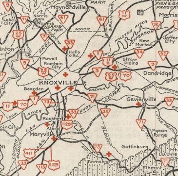
In 1941, Tennessee tried to get US 276 routed over TN 71 from Knoxville to NC. In 1949 (bridge dates), TN 71 was removed from Park Rd south out of Sevierville; Teaster Ln/E. Wears Valley Rd in Pigeon Forge; South River Rd in Pigeon Forge In 1952, US 441 was added to the entirety of TN 71 In 1958, TN 71 was reconstructed to be on both sides of the Pigeon River from the southern end of Pigeon Forge south to the north end of the Gatlinburg Bypass. The original route used today's SB roadway to Beech Branch then crossed the river and used today's NB roadway the rest of the way south. In 1971, TN 71 was removed from Old Broadway at the I-640 and TN 33 interchanges area. About 1999, the freeway connecting TN 158 with the former South Knox Blvd was completed and TN 71 was signed on it (shields remained at interchanges north of the river through at least 2011 per GMSV). This is a little strange as it appears TN 71 was not signed south of the Tennessee River bridge on James White Pkwy nor on Moody Ave to connect back to US 441. Perhaps this was because the James White Pkwy was supposed to tie in directly to US 441 (project cancelled in early 2010s). Also odd is that TN 71 did not appear to be posted with TN 158 north back to US 441 (this movement became impossible after the I-40 rebuild in this area). The part between Sevier Ave and TN 158 was reassigned as TN 634 by 2022. Posting: Unposted currently; TN 71 is secondary above Knoxville and primary below it Secret US Route Overlay: US 441 (71.3 mi) Comment: TN 71 passes through the severely commercialized areas of Pigeon Forge and Gatlinburg on its way to Great Smoky Mountains National Park. Given that US 441 was removed from GSMNP in Dec 1970, does TN 71 still exist there? Maybe. The road itself is owned by the National Park Service but TN 71 mile markers are such that MM 0 is at Newfound Gap and not the SCL of Gatlinburg. County maps for a time had only TN 71 markers withiin the park but more recent ones do have US 441 again. | |||||||