< TN 47 | Home | TN 48A | TN 49 >
|
|
|
| ROUTE LOG |
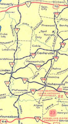
TN 13: 0 - 0 Perry-Wayne Line: 2.7 - 2.7 Lewis-Perry Line: 0.7 - 3.4 TN 20 EB, TN 99 WB: 11.7 - 12.1 US 412, TN 20 WB, TN 99 EB: 0.4 - 12.5 Hickman-Lewis Line: 6.4 - 18.9 TN 100 WB: 6.5 - 25.4 TN 50 EB: 5.3 - 30.7 TN 50 WB: 0.3 - 31.3 TN 100 EB, TN 230 SB: 5.5 - 36.8 TN 230 NB: 2.8 - 39.6 Dickson-Hickman Line: 10.6 - 50.2 I-40 (exit 163): 0.2 - 50.4 TN 48 ALT: 8.9 - 59.3 US 70 Bus, TN 235: 0.4 - 59.7 TN 48 ALT: 0.2 - 59.9 US 70, TN 1, TN 46: 0.4 - 60.3 TN 47: 6.6 - 66.9 TN 49 EB: 0.4 - 67.3 TN 49 WB: 0.4 - 67.7 Montgomery-Dickson Line: 10.3 - 78.0 TN 13 SB: 5.2 - 83.2 TN 149: 5.6 - 88.8 US 41 ALT Byp SB, TN 12 SB, TN 76 EB: 2.6 - 91.4 US 41 ALT Byp NB, TN 12 NB, TN 76 WB: 1.5 - 92.9 US 41 ALT NB, TN 112 NB: 0.2 - 93.1 US 41 ALT SB, TN 112 EB: 0.3 - 93.4 US 79 SB, TN 13 SB: 1.1 - 94.5 US 79 NB, TN 13 NB: 2.2 - 96.7 TN 374: 1.0 - 97.7 TN 236: 3.4 - 101.1 I-24 (exit 1): 0.3 - 101.4 KY STATE LINE: 0.9 - 102.3
|
Creation: An original state route that initially ran from TN 23 (now US 412) near Linden to TN 11 (now US 41) Adams
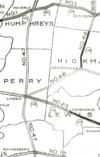
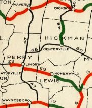
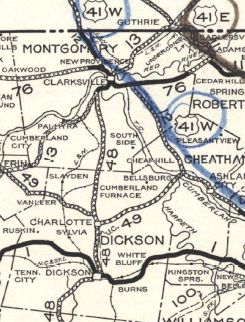
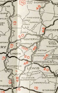
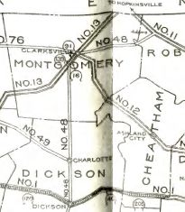
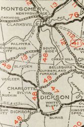
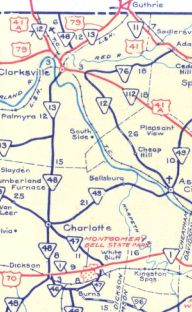
| Adjustments: In 1925 or 1926, TN 48 south was apparently rerouted at Centerville to instead head more westerly to end at TN 47 (now TN 13) Beardstown. The old route to Linden used today's TN 100. Route Logs are contradictory, and it appears not very long after, the route to Beardstown became part of TN 50 (today this is abandoned bridge crossing of the Buffalo River; TN 438; Hwy 50 W Loop; TN 50; Orton Cir east of Duck River and Old State Road 50 in Shipps Bend; TN 50; Old State Route 50 (no longer crosses Duck River to) and West End Avenue into Centerville In 1927 or 1928, TN 48 south was extended from Centerville through Hohenwald and ending at TN 15 (now Old Hwy 64 E) near Waynesboro. From Topsy southward had been part of TN 47 briefly. Also in 1927 or 1928, TN 48 north was truncated to TN 13 (now Palmyra Rd) Hilltop, a little south of Clarksville. This left behind TN 13 to Clarksville and TN 76 to Adams. Today this is River Rd; Zinc Plant Rd across Cumberland River; current TN 13-48; Cumberland Dr into Clarksville; abandoned RR crossing; Academy Ave; US 41 ALT; Golf Club Ln; Memorial Dr; TN 76 to Adams except it used Old Clarksville-Springfield Rd through Port Royal; Port Royal Rd and likely Tolleson Rd; also Commerce St in Adams In 1929, TN 48 was removed from Spencer Alley/Water St/Todd St in Charlotte. Also in 1929, TN 48 was removed from Old SR 48 southwest of Hohenwald Although the 1929 official shows it already, bridges are dated 1930 and 1931 for TN 48 to be removed from the lengthy Cheek Rd/Soules Chapel Rd/Old Highway 48 from Cumberland Furnace through McAllisters Crossroads and Liverworth to Orgains Crossroads Also about 1931, TN 48 was removed from Spencer St/TN 49/Old Highway 48 north out of Charlotte, plus Old 48 N/Leach Rd/Woods Valley Rd through Cumberland Furnace Also bout 1931, TN 48 was removed from Old SR 48/Switch Rd/Goodrich Rd/TN 230/Old Hwy 48 between Centerville and Nunnelly. In 1931 or 1932, TN 48 north was truncated to the relocated TN 13 at Cunningham. TN 48 had used Morgan Cir at Cunningham; Yarbrough Cir and Ball Rd north of Cunningham In 1933, TN 48 was removed from Sweetwater Rd at Sweetwater. In 1934, AASHO tried to get US 43 assigned to the entirety of TN 48. In 1935 or 1936, TN 48 south was rerouted in southwest Lewis County to continue west to TN 13 where it ends today. Today old route to US 64 near Waynesboro is Topsy Rd/Hohenwald Rd/Topsy Rd/TN 99.
In 1943 or 1944, TN 48 was re-extended north with TN 13 through Clarksville, then north as new state highway to Kentucky.
In 1965, TN 13-48 was removed from River Rd/Zinc Plant Rd to a new Cumberland River crossing. It appears TN 48 was moved from Cumberland Ave to Riverside Dr to College St between 1981-86. Posting: Posted as secondary routing from the TN 100 north split to Dickson and from Clarksville to Kentucky; everywhere else is posted as primary routing. The overlay with TN 13 is posted everywhere from TN 12 southward. The overlays with US 41A Bypass, US 41A and US 79 are not posted Secret US Route Overlay: None Comment: TN 48 is one-way southbound in Dickson between Walnut St and US 70 Bus and it is unclear how long it has been this way. Northbound traffic must use TN 48A (which goes back to at least 1982). It is 4 miles shorter to use TN 48 than TN 13 from TN 48's south end to Cunningham where they meet again. | ||||||||||||||
Previous: TN 47 |
Next: TN 48A | TN 49
Top | Tennessee Hwy Index
Home
Page last modified 16 January 2021