< TN 75 | Home | TN 76 Byp | TN 77 >
|
|
|
| ROUTE LOG |
TN 57: 0 - 0 TN 193: 6.9 - 6.9 TN 195: 4.5 - 11.4 TN 460: 0.5 - 11.9 US 64, TN 15: 1.1 - 13.0 TN 59: 2.3 - 15.3 Haywood-Fayette Line: 9.3 - 24.6 TN 179 WB: 0.7 - 25.3 TN 179 EB: 4.9 - 30.2 I-40 (exit 56): 4.5 - 34.7 US 70 WB, US 79 SB, TN 1 WB, TN 19 WB: 2.7 - 37.4 TN 19 EB: 0.8 - 38.2 US 70 EB, US 70 ALT Begin, TN 1 EB: 0.5 - 38.7 TN 369: 1.2 - 39.9 Crockett-Haywood Line: 10.1 - 50.0 TN 88 WB: 1.0 - 51.0 TN 88 EB: 0.2 - 51.2 US 412, TN 20: 1.5 - 52.7 TN 221: 5.4 - 58.1 Gibson-Crockett Line: 4.1 - 62.2 US 70 ALT EB, US 70 ALT Bus Begin, US 79 NB, US 79 Bus Begin, TN 366: 0.3 - 62.5 US 45W Bus NB, TN 5 NB: 1.0 - 63.5 US 45W Bus SB, TN 5 SB: 0.5 - 64.0 TN 152: 0.3 - 64.3 US 45W, US 70 ALT WB, US 70 ALT Bus END, US 79 SB, US 79 Bus END, TN 366: 1.1 - 65.4 TN 187: 1.8 - 67.2 TN 186: 2.2 - 69.4 US 45E, TN 43, TN 77 WB, TN 104: 5.9 - 75.3 TN 425: 1.9 - 77.2 TN 77 EB: 2.3 - 79.5 Carroll-Gibson Line: 0.2 - 79.7 TN 220: 1.6 - 81.3 US 70 ALT EB, TN 77 EB: 1.6 - 82.9 TN 220 ALT: 0.6 - 83.5 TN 77 WB: 0.6 - 84.1 TN 105: 3.6 - 87.7 TN 436: 9.7 - 97.4 TN 124: 0.5 - 97.9 TN 423: 0.4 - 98.3 TN 22: 1.1 - 99.4 Henry-Carroll Line: 1.1 - 100.5 TN 218: 11.8 - 112.3 US 641, TN 69: 1.4 - 113.7 TN 356: 0.9 - 114.6 TN 218 SB: 3.3 - 117.9 TN 218 NB: 3.0 - 120.9 TN 140: 7.1 - 128.0 TN 119: 2.6 - 130.6 Stewart-Henry Line: 1.5 - 132.1 TN 232: 4.4 - 136.5 TN 461: 5.8 - 142.3 TN 49: 3.0 - 145.3 TN 120: 8.9 - 154.2 TN 46: 3.5 - 157.7 Montgomery-Stewart Line: 2.3 - 160.0 TN 233: 5.5 - 165.5 TN 374: 4.0 - 169.5 US 41 ALT NB, TN 12 NB: 3.9 - 173.4 US 41 ALT SB, US 41 ALT Byp Begin, US 79 NB, TN 13 NB, TN 112: 1.5 - 174.9 TN 48 NB: 0.8 - 175.7 TN 13 SB, TN 48 SB: 1.5 - 177.2 TN 12 SB: 4.5 - 181.7 US 41 ALT, US 41 ALT Byp END, TN 112: 1.1 - 182.8 I-24 (exit 11): 3.2 - 186.0 TN 238: 5.3 - 191.3 Robertson-Montgomery Line: 1.1 - 192.4 TN 256: 4.3 - 196.7 US 41 NB, TN 11 NB: 0.4 - 197.1 US 431 NB, TN 65 NB: 6.7 - 203.8 US 41 SB, US 431 SB, TN 11 SB, TN 49 WB, TN 65 SB: 1.5 - 205.3 TN 49 EB: 1.2 - 206.5 I-65 (exit 108): 11.1 - 217.6 TN 258: 1.0 - 218.6 US 31W SB, TN 41 SB: 0.7 - 219.3 US 31W NB, TN 41 NB: 0.2 - 219.5 Sumner-Robertson Line: 0 - 219.5 TN 25: 3.9 - 223.4 TN 109: 6.4 - 229.8
|
Creation: An original state route. In 1924 it ran from TN 49 Dover to TN 13 (now College at 2nd) Clarksville.
|
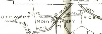
Adjustments: In 1925 or 1926, TN 76 was extended east replacing TN 48 to TN 11 (now TN 256) Adams.
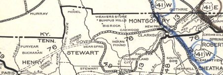
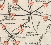
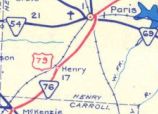
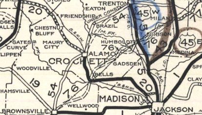
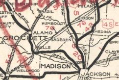
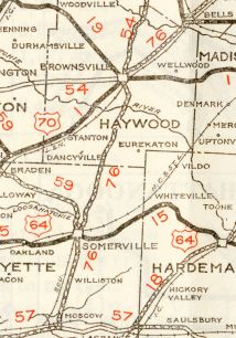
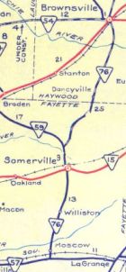
In 1927, Tennessee tried to get TN 76 between Dover and Clarksville into the US highway system In 1927 or 1928, TN 76 was extended west as new state highway to Paris, then replaced TN 43 to McKenzie, then extended southwest as new routing (except joined TN 77 from Atwood to Milan) to Brownsville, then south as more new routing to end at TN 57 Moscow. Tennessee tried to get this into the US highway system between McKenzie and Paris) In 1929, TN 76 was removed from Chickasaw Rd from Paris to India. In 1930 (bridge dates), TN 76 was given its current routing between Bells and Humboldt. The original route from Bells to Gadsden is a little uncertain but may have used Cypress Church Rd to Webb Town Rd to Bailey Rd to Plomar Williams Rd then Central St. From Gadsden, the original route used Central St and something close to the footprint of current TN 76, then Tinsley Rd briefly, then northeast on now-abandoned alignment (clearly visible on 1947 aerial) to Tom Dunlap Rd to Cypress Tree Rd to Cypress Tree Ext which no longer crosses the Middle Fork Deer River to connect with S. 3rd Ave into southern Humboldt. Also in 1930 (bridge dates), TN 76 was given its routing from Gibson to Milan. It appears the old route used TN 186, Sanders Stor to Milan Rd and Golden Eagle Rd (the 1929 Official shows 2 RR crossings and entering Milan south of the RR). Also in 1930, TN 76 was removed from Old Clarksville-Springfield Rd through Port Royal; Port Royal Rd and likely Tolleson Rd Official Maps show this occurring in 1931 or 1932 but the bridges are all dated 1934 for TN 76 between Brownsville and Bells. Originally, TN 76 used College St and Boyd Ave east out of Brownsville, then Poplar Corner Rd to Poplar Corner. TN 76 then used Norris Crossing Rd and Shella Barger Rd to Old Bells Rd, which used to continue across S. Fork Deer River and connected to Webb St and Main St into Bells In 1931 or 1932, TN 76 was extended north over old US 41E to new US 41E (current US 41). In 1932, TN 76 was removed from Price Rd between Moscow and Williston. It is unclear if TN 76 also was using until 1932 Evergreen Dr/Ebenezer Loop/La Grange Rd up to Somerville. In 1937, AASHO tried to assign US 42 from Brownsville to Clarksville. By 1938, TN 76 was removed from Old Dover Rd west of Clarksville; Liverpool Rd/Indian Mound Rd/N Old Dover Rd in the Oakwood area; Golf Club Ln in eastern Clarksville In 1940, TN 76 was moved from Commerce St to Church St in Adams. In 1944, US 79 was assigned to TN 76 from Brownsville to Clarksville. Also in 1944, TN 76 was removed from Old Paris Rd north of McKenzie; Skunk Hollow Rd; "Old SR 76" south of Henry; Atlantic Ave/Elm St/Lumber Rd/Brown St in Henry (route began using Pioneer Rd through Henry) Also in 1944, TN 76 was removed from Old McKenzie Hwy from Routon to Paris and removed from Dunlap St/Wood St within central Paris. Wood St became part of TN 69 (now TN 356).
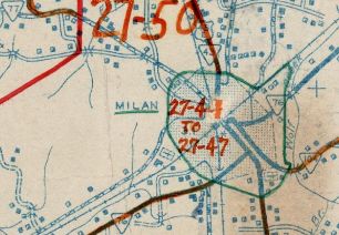
Also in 1944, TN 76 was rerouted around the expanded Eagle Creek west of Paris Landing State Park. Surviving pieces of the old route are Bull Durham Rd west of Eagle Creek; bridge fragments in the middle of the water; a bit of Eagles Nest Rd; more bridge bits; most of TVA Access Rd (the original alignment meets current US 79 right at the current TN 119 jct) About 1948, TN 76 was given its direct routing through Milan. Prior to this it used Highland St, College St, Main St, Williamson St and Park Ave.
In 1951, TN 76 was rerouted at Somerville to functionally replace TN 59 about 2 miles then continued as newly constructed route to nearly Haywood County. The original route used Old Brownsville Rd.
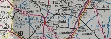
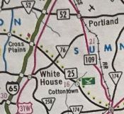
Also in 1951, TN 76 was removed from Main St, Paris Ave and Paris Pike in McKenzie. In 1952, TN 76 was removed from Hatchie St/Washington St and instead placed on Anderson Ave/Main St to reach central Brownsville. By 1953, TN 76 was put on one way splits through downtown Clarksville - WB used 3rd/College and EB used the original routing of 2nd/Madison. In 1957, TN 76 was removed from Harmony Church/Old harmony Church Rds at the Montgomery-Robertson line which used to connect back to TN 76 at about S. Bryant Rd. The former Sulphur Fork Bridge is still standing. In 1958, TN 76 was removed from the lengthy Old Hwy 79 from east of Dover to TN 120. Between 1958-60, TN 76 was extended east with US 41 to Springfield, then east with Tn 49 briefly before extending as new state highway to US 31W White House. It appears TN 76 was placed on its modern route from the Tennessee River to west of Dover in a couple stages in the early 1970s. The original route used Old Paris Landing Rd; Walnut Grove Rd; Onion Hill Rd; Pumpkin Ridge Rd/Gentry Cir; Buckner Rd In the late 1970s, TN 76 was removed from Memorial Dr and went further down Madison (US 41A) to leave at MLK Jr Pkwy. In 1983, TN 76 was extended north with US 31W briefly, then northeast to end at TN 109 below Portland.
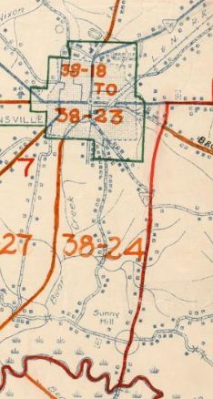
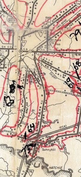
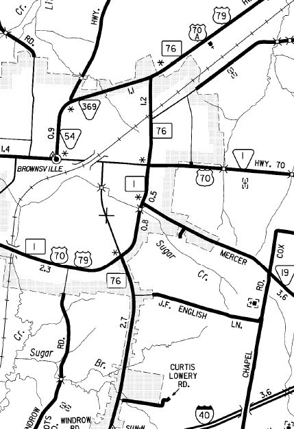
Also in 1983, TN 76 was placed on its current Brownsville bypass, replacing TN 76 Byp. Washington Ave north of Main remains part of TN 54 and TN 369. Main St remained US 70 (since moved) and Anderson Ave was removed from the state highway system.
Also in 1983, TN 76 was removed from central Clarksville and placed on US 41A Byp Riverside Dr all the way around to where it connected with Madion/MLK Jr Pkwy. This also replaced TN 112A between TN 12 and US 41A. In 1984, TN 76 was removed from Church St in Dover. About 2003, TN 76 was removed from Pioneer Rd through Henry and Camp Tyson Rd through Routon About 2006, TN 76 was removed from Dover Rd through Oakwood In 2008, TN 76 was removed from Woodlawn Rd west of Clarksville In November 2024, TN 76 was moved to the partly completed Atwood Bypass, then west with TN 77 back into town to the original route. It appears the old route is still TN 77. Posting: Posted as secondary from Springfield to TN 109 and primary everywhere else it is posted. TN 76 is not posted on its US 79, US 79 Bus or US 41A Byp overlays (143 continuous miles) TN 76 is not posted on its US 41 or Tn 49 overlay but is osted on its US 31W overlay. Secret US Route Overlay: US 79 I (25.1 mi) US 79 Bus (2.9 mi) US 79 II (107.1 mi) US 41A Byp (7.9 mi) Comment: TN 76 is the 3rd longest state route in Tennessee US 79/TN 76 is the best way to get from the Memphis region to Clarksville. TN 76 serves Fort Donelson Nat'l Battlefield; Port Royal and Paris Landing State Parks | ||||||||||||||||||||