< TN 48 | Home | TN 50 >
|
|
|
| ROUTE LOG |
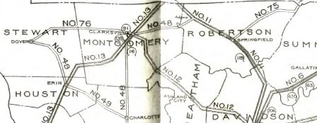
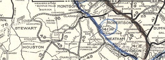
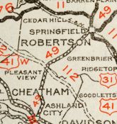
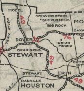
US 79, TN 76: 0 - 0 TN 233: 9.8 - 9.8 Houston-Stewart Line: 6.5 - 16.3 TN 147: 1.0 - 17.3 TN 149: 5.0 - 22.3 TN 13: 0.2 - 22.5 TN 46 NB: 3.9 - 26.4 TN 46 SB: 5.2 - 31.6 Dickson-Houston Line: 0.8 - 32.4 TN 235 NB: 4.3 - 36.7 TN 235 SB: 3.6 - 40.3 TN 48 NB: 6.5 - 46.8 TN 48 SB: 0.4 - 47.2 Cheatham-Dickson Line: 14.2 - 61.4 Dickson-Cheatham Line: 1.0 - 62.4 Cheatham-Dickson Line: 0.1 - 62.5 TN 249 SB: 2.4 - 64.9 TN 455: 0.7 - 65.6 TN 12: 0.4 - 66.0 TN 249 NB: 2.2 - 68.2 US 41 ALT, TN 112: 7.3 - 75.5 Robertson-Cheatham Line: 0.2 - 75.7 I-24 (exit 24): 0.1 - 75.8 TN 257: 5.7 - 81.5 US 41, US 431, TN 11, TN 65, TN 76 WB: 5.5 - 87.0 TN 76 EB: 1.2 - 88.2 TN 25 WB: 4.1 - 92.3 TN 25 EB: 0.6 - 92.9 TN 52: 6.8 - 99.7 KY STATE LINE: 3.6 - 103.3
|
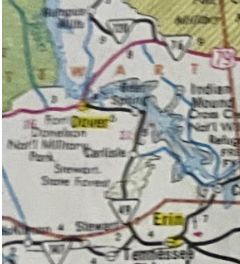
Creation: An original state route that initially ran from TN 76 (now US 79) Dover to TN 48 (now Old Highway 48) northwest of Charlotte.
| Adjustments: In 1927 or 1928, TN 49 east was extended with TN 48 to Charlotte, then northeast as new highway to TN 12 near Cheap Hill; followed TN 12 to Ashland City; northeast as new routing to Springfield; replaced TN 75 to Orlinda; new routing north to Kentucky. In 1931, TN 49 was removed from York Rd/Ewell Elliot Rd/Woods Rd/Glover Rd/Lahr Rd/Main St from Pleasant Hill to Springfield. In 1932, TN 49 was removed from Cumberland City Hwy and abandoned routing back to roughly current TN 13-49 jct; also removed from Old 49 Hwy/Town Branch Rd and Dr. Stokes Ln east of Erin
In 1933 (bridge date, though shown on 1932 official), TN 49 was given a new routing from Dickson County across the Harpeth River at Ashland City. This left behind Dozier Boat Dock Rd, abandoned ferry across Cumberland River, abandoned routing to Chapmansboro, and TN 12 (now Chapmansboro Rd east to current TN 12). In 1934, TN 49 was wxtended west with TN 76 a couple miles, then northwest as new state highway to Kentucky. Between 1929-37, TN 49 was removed from Spencer Alley within Charlotte. If TN 49 ever used Brookhollow Dr in Ashland City it stopped doing so by 1939. By 1954, TN 49 was removed from Old Hwy 49 near Bellsburg; also by 1954 TN 49 was removed from Golf Course Rd/Norman Harris Rd/Old State Hwy 49/long abandoned stretch to nearly Old Clarksville Rd south of Pleasant View. In 1970, TN 49 was removed from Tom Stanfill Loop west of the Houston/Dickson Line In the early 1970s, US 79/TN 49 was removed from Buckner Cir. Between 1955-81, TN 49 was removed from Spencer Ln west off TN 48 in Charlotte. Between 1974-81, TN 49 west was truncated back to US 79 Dover. The road to Kentucky became The Trace (Land Between the Lakes), though the first 3 miles is now TN 461. Note that US 79/TN 49 was still using Church St out of Dover at that time.
Posting: Posted as primary routing everywhere except northeast of TN 25 which is secondary posting. The overlays with TN 25 and TN 48 are posted. Secret US Route Overlay: None Comment: Forms a wide V-shape in northern Tennessee; connects I-24 to Ashland City and Springfield | ||||||||||
Previous: TN 48 |
Next: TN 50
Top | Tennessee Hwy Index
Home
Page last modified 15 January 2021