< SC 8 | Home | SC 9 ALT | SC 9 Bus | SC 10 >
|
|
|
| ROUTE LOG |
SC 65: 0 - 0 US 17 SB: 1.8 - 1.8 SC 90: 0.9 - 2.7 US 17 NB: 0.1 - 2.8 SC 31: 2.0 - 4.8 SC 905: 5.3 - 10.1 SC 9 Bus: 7.2 - 17.3 US 701: 6.5 - 23.8 SC 9 Bus, SC 410: 6.4 - 30.2 US 76 EB: 11.4 - 41.6 Marion-Horry Line: 0.7 - 42.3 US 76 WB: 0.9 - 43.2 Dillon-Marion Line: 2.5 - 45.7 SC 41: 6.1 - 51.8 SC 57 SB: 12.5 - 64.3 US 301 SB, US 501 SB, SC 34: 1.0 - 65.3 US 301 NB, US 501 NB: 1.0 - 66.3 I-95 (exit 193): 1.1 - 67.4 SC 57 NB: 3.3 - 70.7 Marlboro-Dillon Line: 7.4 - 78.1 SC 381: 4.7 - 82.8 US 15 NB, US 401 NB: 7.7 - 90.5 SC 9 Bus, SC 38 SB, SC 38 Bus: 1.2 - 91.7 US 15 SB, US 401 SB: 0.8 - 92.5 SC 385: 0.5 - 93.0 SC 9 Bus, SC 38 NB: 1.5 - 94.5 SC 79: 3.9 - 98.4 SC 912: 1.3 - 99.7 SC 177: 6.4 - 106.1 US 1 NB: 0.8 - 106.9 Chesterfield-Marlboro Line: 1.1 - 108.0 US 52 NB: 0.8 - 108.8 US 1 SB, US 52 SB: 1.4 - 110.2 SC 102: 11.5 - 121.7 SC 145: 0.3 - 122.0 SC 265: 3.9 - 125.9 SC 109 SB: 2.1 - 128.0 SC 109 NB, SC 268: 3.2 - 131.2 SC 151: 9.3 - 140.5 US 601 NB, SC 151 Bus: 0.4 - 140.9 SC 207: 0.5 - 141.4 US 601 SB: 2.9 - 144.3 Lancaster-Chesterfield Line: 3.8 - 148.1 SC 522: 6.9 - 155.0 US 521 SB, SC 9 Bus: 7.2 - 162.2 SC 200: 1.8 - 164.0 US 521 NB, US 521 Bus: 0.2 - 164.2 SC 9 Bus: 3.1 - 167.3 Chester-Lancaster Line: 2.6 - 169.9 US 21: 1.9 - 171.8 SC 99: 5.1 - 176.9 SC 901 SB: 3.1 - 180.0 SC 223: 0.2 - 180.2 SC 901 NB: 1.2 - 181.4 I-77 (exit 65): 0.2 - 181.6 SC 909: 3.3 - 184.9 SC 9 Bus, SC 72 EB, SC 121 NB: 6.5 - 191.4 US 321 SB, US 321 Bus, SC 97: 1.2 - 192.6 SC 72 WB, SC 121 SB: 1.9 - 194.5 SC 9 Bus: 0.7 - 195.2 US 321 NB: 0.4 - 195.6 SC 49 NB: 13.8 - 209.4 Union-Chester Line: 0.3 - 209.7 SC 49 WB: 0.3 - 210.0 SC 105: 2.2 - 212.2 SC 114: 8.9 - 221.1 SC 18 SB: 1.9 - 223.0 SC 18 NB: 1.1 - 224.4 Spartanburg-Union Line: 5.3 - 229.7 SC 150: 1.4 - 231.1 US 176 EB, SC 295: 2.3 - 234.4 I-585 Spur Begin, US 29: 8.6 - 243.0 SC 296: 0.4 - 243.4 I-585 Begin, I-585 Spur End, US 221: 1.2 - 244.6 I-585 NB (exit 25), US 176 WB: 0.3 - 244.9 I-85 Bus (exit 6): 1.4 - 246.3 I-85 (exit 75): 1.3 - 247.6 SC 292: 7.3 - 254.9 SC 11: 2.6 - 257.5 NC STATE LINE: 5.7 - 263.2
|
Creation: An original state route that originally ran from SC 10 (now Waterside Park Dr) Enoree east through Union, Chester, Lancaster, Cheraw, and Bennettsville before ending at SC 23 (likely SC 34/S-17-25 jct) Dillon. This is the only SC 9.
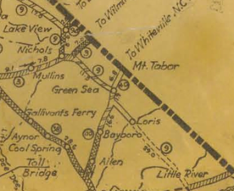
| Adjustments: In 1925 or 1926, SC 9 was extended east as new primary routing to Nichols, then replaced SC 47 to Green Sea then after a brief south overlay with SC 40 (now SC 410) continued as new primary routing via Loris and Wampee to enter North Carolina near Little River.
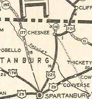
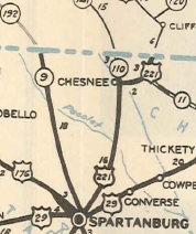
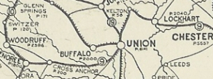
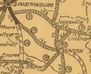
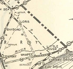
Also in 1925 or 1926, SC 9 west was rerouted at Kelly to instead head west as mostly new primary routing through Jonesville to end at SC 19 (now SC 56) Spartanburg. The old routing southwest through Union to Enoree became SC 92. Today this is Waterside Park Dr and Rock St in Enoree; SC 92 to Cross Anchor except: S-42-256 Ice House Rd; S-42-10; New Hope Church Rd. It is SC 49 from Cross Anchor to Union except: Red Barn Rd and Compton Cirle west of Cross Keys; S-44-18 and S-44-22 through the Cross Keys crossroads; unclear if SC 9 used Boatman Springs Rd east of the Tyger River. At Union SC 9 used S-44-6 Main St; SC 18; S-44-48 Pinckney St; SC 49 Arthur Blvd; S-44-122 Calhoun St; S-44-383 Lakeside Dr; S-44-69 Peach Orchard Dr; S-44-382 Barnado Rd; S-44-4 to Kelly. Also in 1925 or 1926, SC 9 was rerouted between Lancaster and Pageland to follow a southern arc. The original path was secondary for a while but is now again the SC 9 corridor. If SC 9 ever used the length S-42-240 and S-42-227 Main St through Pacolet along with S-42-108 Elmore Rd it stopped doing so by 1927. In 1932, SC 9 east was truncated to SC 49 (now S-26-20) Nixons Crossroads. The road through Little River to NC became part of SC 49 (now SC 90 and US 17). In 1932, SC 9 was removed from SC 909/S-12-41 and S-12-559 in the Rodman area. SC 9 was removed from S-29-57 Old Landsford Rd/York St by 1932. If SC 9 ever used Bascus St/Scott St south out of Lake View; Currie Rd at the Dillon-Marlboro Line it stopped doing so by 1932. If SC 9 ever used Cobblestone Rd south of Green Sea it stopped doing so by 1934. In 1934 or 1935, SC 9 east was rerouted at Loris to head directly as new primary routing to US 17 Nixons Crossroads. Loris to Wampee is probably S-26-348, S-26-347, and S-26-638 which used the now abandoned Star Bluff Ferry. Wampee to Nixons Crossroads became an extended SC 90. Also in 1934 or 1935, SC 9 was extended with US 176 through Spartanburg, then replaced SC 177 north through Boiling Springs and New Prospect to North Carolina.
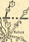
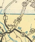
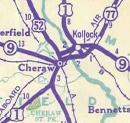
Also in 1934 or 1935 it appears SC 9 was removed from today's S-35-36 between Kollock and Bennettsville. In the process, SC 9 was placed on new construction then replaced SC 98 southwest to the old routing. Also in 1934 or 1935, SC 9 was removed from John Price Rd and Sand Castle Rd east of Pageland; S-13-39 southwest of Pageland. In 1936 or 1937, SC 9 was removed from Old Loris-Longs Rd east of Loris. In 1939, SC 9 was rerouted in Cheraw and eastward to meet the new Pee Dee River bridge that SC 9 still uses today. The old route may have briefly been SC 9 ALT. Today it is 2nd St and Church St and on the other side of the river it is S-35-52.
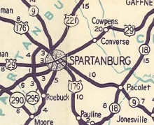
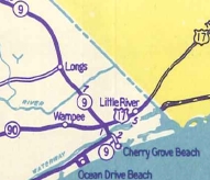
Also in 1939, SC 9 was removed from S-12-475 Poulos Rd and abandaoned routing across Turkey Creek; S-12-572 Land Rd; S-12-54 Mt Pleasant Church Rd plus abnadoned routing; S-12-746 Turnbuckle Rd In 1940, SC 9 was extended with US 17 across the Intracostal Waterway, tehn as new primary routing to end at Cherry Grove Beach. Between 1939-43, SC 9 was removed from Peach Shed Rd east of Jonesville. About 1946, SC 9 was moved onto Pine St entering Spartanburg as new primary routing and construction, then used US 29 Main St back to Church St. US 176 remained on Church St. The old route between SC 9 and then-US 176 became SC 9 ALT but it is today S-42-34, SC 295 and SC 56.
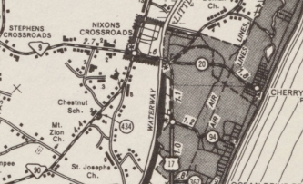
In 1947, SC 9 east was truncated back to US 17-SC 90 Nixon Crossroads, leaving behind S-26-20.
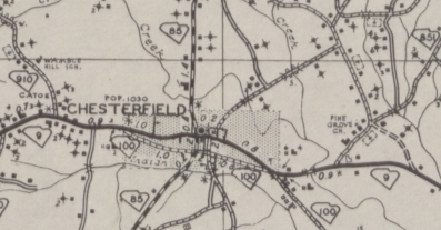
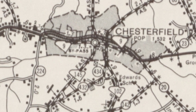
In 1949, SC 9 was given its bypass south of Chesterfield over what had been SC 100 prior to 1947. The old route through Chesterfield became SC 9 Business (now S-13-1). Official maps showed the bypass as well as the 1949 Official having a SC 9 BUSINESS graphic on the reverse, however county maps didn't explicitly label it until the 1960s.
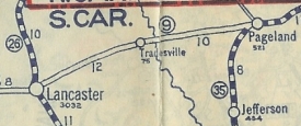
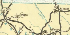
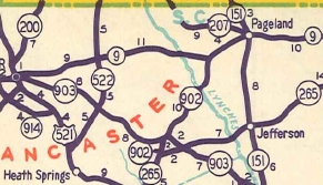
Also in 1949, SC 9 was restored to a direct routing between Lancaster and Pageland, replacing SC 906. The old route became SC 903 and SC 902 (now US 601 except at the Lynches River where it used the Wintertide Dr crossing which is S-13-823 on the Chesterfield County side).
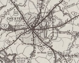
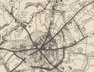
Between 1941-52, SC 9 was removed from Old Boiling Springs Rd just north of Spartanburg. In 1956, SC 9 was placed on its bypass around the south of Chester, leaving behind SC 9 Business.
In 1960, SC 9 was placed on the newly constructed Pine St north of US 29 that funnels into the new I-585. The old route remained part of US 29 and Church St became SC 56. Between Church St and I-585 became a small piece of US 221 and a US 176-221 CONN.
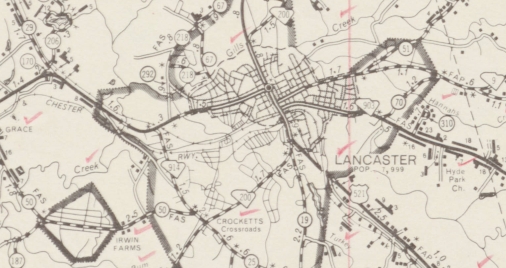
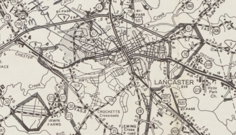
In 1966 or 1967, SC 9 was placed on its bypass around the north of Lancaster leaving behind SC 9 Business (some of this is now S-29-2 Main St and S-29-866 Arch St).
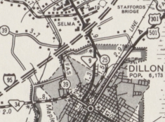
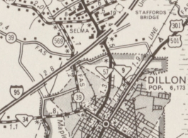
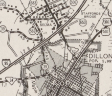
Between 1969-71, SC 9 was given its current routing through Dillon replacing some of S-17-25 plus new construction, leaving behind SC 57 (now S-17-96 and SC 34).
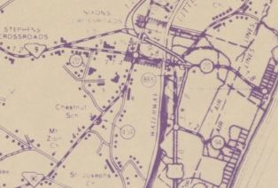
About 1971, SC 9's east end moved from Nixons Crossroads to the newly constructed US 17/SC 9 interchange nearby. The old SC 9 ending became more S-26-20.
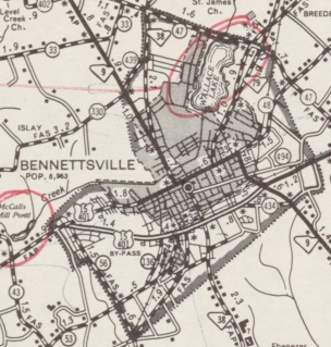
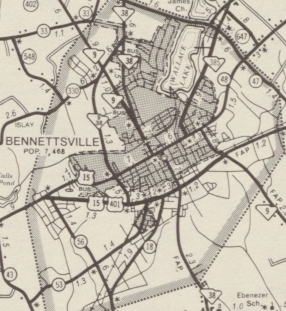
Between 1975-78, SC 9 received its bypass of Bennettsville using existing US 15-401 and new construction around the west. The old route became SC 9 Business (some of this is now SC 385 CONN and SC 385)
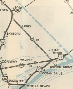
About 1982, SC 9 was placed on newly constructed bypass of Green Sea and Loris, leaving behind S-26-441 and SC 410 through Green Sea and SC 9 Business through Loris.
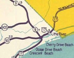
In 1987, SC 9 east was extended with US 17 across the Intracoastal Waterway, then replaced SC 65 out to its current end at Cherry Grove Beach.
Improvements: SC 9 was first paved in 1928 from Spartanburg to Glendale. In 1931, SC 9 was paved from Glendale to Jonesville; Little Rock to a few miles east of Dillon; US 17 (now US 76) duplex in Nichols. In 1932, SC 9 was paved from Chester to about 7 miles southeast of Lancaster; SC 265 jct to Wallace; today's SC 79 to Little Rock; Lake View to Nichols In 1933 SC 9 was paved from Wallace to today's SC 79; Nichols to Green Sea In 1934 SC 9 was paved from Kelly to Lockhart and now continuously between Chester and Loris. The 1936 extension from Spartanburg to NC was paved upon designation. In 1937, SC 9 was paved from Jonesville to Kelly. In 1938, SC 9 was paved from Loris to about Longs. In 1939, SC 9 was paved from Lockhart to Chester. In 1940, SC 9 was paved from Longs to US 17. In 1941, SC 9 was paved from US 17 to Cherry Grove Beach, completing the hard surfacing of the route. SC 9 was multilaned from Cheraw to Wallace and also on the I-585 multiplex down to a mile below US 29 in 1960. Between 1966-67, SC 9 was multilaned from the Catawba River to the eastern end of the Lancaster Bypass. In 1974, SC 9 was multilaned on a short segment east of Lockhart and also from I-95 to central Dillon. In 1975, SC 9 was multilaned from Spartanburg out to Glendale; also from Cheraw west several miles. In 1977, SC 9 was multilaned on the Chester Bypass; SC 265 to the piece from Cheraw; Wallace to Bennettsville When SC 9 was placed on the US 15-401 bypass of Bennettsville between 1975-78 it was already multilane. In 1978, SC 9 was mulitlaned from Fort Lawn to the Catawba River. In 1979, SC 9 was multilaned from I-585 north to Parris Bridge Rd. In 1982, the SC 9 bypass open from US 701 east to SC 9 Business was multilaned Between 1983-85 the rest of the Green Sea-Loris bypass was opened as 4-lane. Between 1986-87 SC 9 was multilaned from Parris Bridge Rd north to Boiling Springs. In 1987 or 1988 SC 9 was multilaned from the east end of Loris bypass to US 17. In 1992 SC 9 was 4-laned from SC 909 across I-77 to Richburg. Between 1995-96 SC 9 was 4-laned from Glendale to the new US 176-SC 9-SC 295 jct near Pacolet. Between 1998-99 SC 9 was multilaned from US 17 to Cherry Grove Beach . In 2012, SC 9 was multilaned from Chester to SC 909; Richburg to Fort Lawn Comment: SC 9 is probably South Carolina's most important non-US route, crossing the northern tier of South Carolina from Spartanburg to Chester, Lancaster, Chesterfield, Cheraw, Bennettsville, Dillon, and to the Grand Strand. There is a posted SC 9 TRUCK for Cheraw using US 52 and S-13-51 Four Mile Loop. I used to think SC 9 from Cheraw east to the beach should be part of an extended US 220 but with I-73 overrunning US 220 in North Carolina it would actually make more sense to eliminate US 220. A US x74 would make some sense for SC 9 from Spartanburg to the beach but it would have to either also use SC 9 into NC or be put onto I-26 to comply with the rules for US route designations... | |||||||||||||||||||||||||||||||||||||||||


Previous: SC 8 |
Next: SC 9 ALT | SC 9 Bus | SC 10
Top | South Carolina Hwy Index
Home
Page last modified 24 June 2016