< SC 89 | Home | SC 90 ALT | SC 91 >
|
|
|
| ROUTE LOG |
US 501 Bus: 0 - 0 SC 22: 13.0 - 13.0 US 17, SC 9: 10.6 - 23.6 US 17: 1.0 - 24.6
|
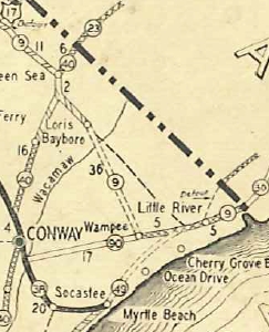
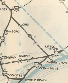
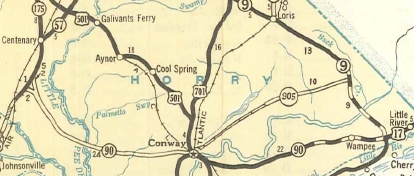
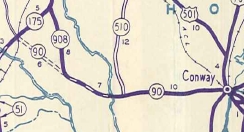
Creation: SC 90 appeared in 1929 as new primary routing running from SC 38 (now S-26-14) to SC 9 (now S-26-638) Wampee. This is the only SC 90.
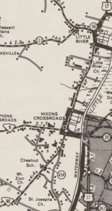
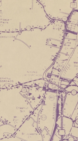
| Adjustments: In 1934 or 1935, SC 90 was extended east over SC 9 to end at US 117/SC 9 (now S-26-20) Nixon Crossroads.
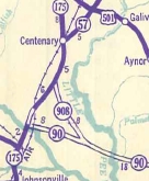
In 1937, SC 90 was extended west as new construction to the rerouted US 501 (now US 501 Bus). This left behind the original west ending of SC 90 along today's S-26-345 Dobros Rd. SC 90 was then extended with US 501 into Conway, then west as new primary routing by Act of SC Legislature to end at SC 175 (now S-34-9) near Gresham. In 1938, SC 90 was rerouted in southern Marion County to instead head north to SC 175 (now SC 41) near Brittons Neck. In 1939, SC 90 was rerouted in Marion County again to head to Gresham. The route north to Brittons Neck became SC 908.
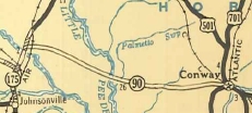
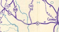
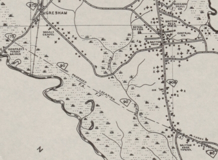
By 1940, SC 90 was removed from Steritt Swamp Rd; Isaac Rd and a lengthy Old State Hwy 90 at Nixonton; The 1941 Official shows SC 90 west of SC 908 as a projected road (1937, 1939, and 1940 Officials all show an actual road, while the 1940 Marion County map shows a gap in SC 90 with the western part using today's S-34-206 from Gresham to S-34-206 and the eastern part ending at the SC 90-908 jct with no road at all between the two parts. The 1943 Marion County map removes SC 90 from the western part and instead shows a projected SC 90 road from SC 908 to SC 175 near the Pee Dee River Bridge.
In 1952, SC 90 west was truncated to its current Conway endpoint leaving behind US 501 into Conway, and US 378 west to today's SC 41. Official maps up through 1951 continued to show west of SC 908 as projected roadway.
In 1970, SC 90 was extended east over US 17 to the current SC 90 endpoint.
About 2009, SC 90 was rerouted slightly to accommodate the construction of the Robert Edge Parkway, leaving behind abandoned routing. This provides SC 90 with nearly direct access to the SC 31 freeway which up to this point there had been no access of any kind. Improvements: The first few miles east of Red Hill were paved in 1938 All of SC 90 east of Red Hill was paved in 1939 In 1940, SC 90 was paved 5 miles westward from Conway. In 1941 or 1942, SC 90 was paved west to the Little Pee Dee River. By 1948, SC 90 was paved west to SC 908. SC 90 is multilane only in the immediate vicinity of Robert Edge Pkwy. Comment: SC 90 serves eastern Horry County. SC 90 along with S-26-57 and US 701 make a decent Grand Strand Bypass. | ||||||||||||||||

Previous: SC 89 |
Next: SC 90 ALT | SC 91
Top | South Carolina Hwy Index
Home
Page last modified 23 October 2015