< SC 46 | Home | SC 48 >
|
|
|
| ROUTE LOG |
US 301: 0 - 0 SC 6, SC 267: 5.6 - 5.6
|
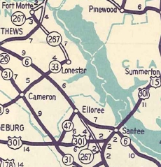
Creation: Appeared about 1929 as new primary routing running as it does today. This is the 2nd SC 47.
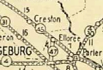
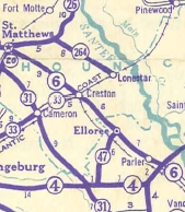
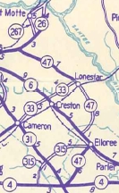
| Adjustments: In 1940, SC 47 was extended west with SC 6 a bit, then as new primary routing to Lone Star, then replaced SC 264 northwest to SC 26 (now US 601). In 1947, SC 47 north was truncated back to Elloree. SC 6 to Lone Star became S-38-38 and S-9-18 (now SC 267 except SC 47 cut over to Lone Star via S-9-130); Lone Star to SC 26 became S-9-11.
Improvements: SC 47 was paved from SC 4 (current US 301) to Elloree in 1937. The Lone Star to SC 26 (current US 601) piece was paved upon designation in 1940. SC 47 has no multilane segments. Comment: SC 47's south end continues as a dirt road connector to US 176, which I always thought should be paved and upgraded. There is a signed SC 47 TRUCK for Elloree that uses SC 6-267, S-38-1023, and S-38-81. | Previous SC 47's:
1925 ROUTE LOG SC 40: 0 - 0 SC 3 EB: 11.3 - 11.3 Marion-Horry Line: 0.7 - 12.0 SC 3 WB: 0.9 - 12.9 Dillon-Marion Line: 2.7 - 15.6 NC STATE LINE: 7.9 - 23.5 |
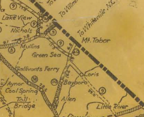
SC 47 #1: Appeared about 1923 as new primary routing, running from SC 40 (now SC 410) Green Sea northwest to North Carolina above Lake View
In 1925 or 1926, SC 47 was renumbered as SC 9 from Green Sea to Lake View (a bit of this is S-26-441) and SC 94 (now the SC 9-41 CONN and SC 41) from Lake View to the North Carolina line. SC 47 may have used Bascus St/Scott St south out of Lake View.
|
||||||||||||

Previous: SC 46 |
Next: SC 48
Top | South Carolina Hwy Index
Home
Page last modified 20 January 2016