< WV 972 | Home | WV 1 >
| Unnumbered Primary Routes not currently assigned | ||||||
| Previous Unnumbered Primary Routes's:
|
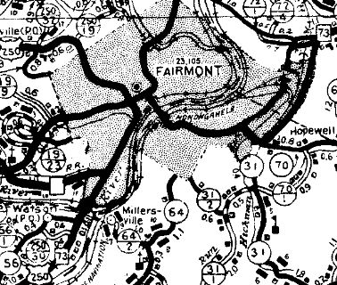
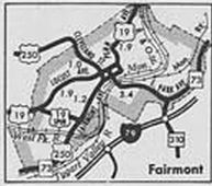
These are all from WVDOT Annual Reports 1931-41, which gave detailed listings of all primary routes followed by "unnumbered primary routes." Unnumbered #1: Appeared in 1931 as a renumbering of WV 8 between Davy and Welch. Although county maps by 1935 started showing this as CR 7, WVDOT Annual Reports continued to describe this as an unnumbered primary route until between 1937-41. Unnumbered #2: Appeared in 1931 as a renumbering of WV 67 from Matoaka to Carrs Schoolhouse. About 1935, this became WV 71. Unnumbered #3: Appeared in 1931 as new primary routing, though this had been part of WV 58 in the early 1920s. Ran from WV 24 (now US 219) from Breedlove to Brookside. In 1932, this became WV 24W. Today it is WV 24 except the original routing used CR 24/8; CR 24/15 near Horse Shoe Run; CR 57/5 and CR 57/6 in Eglon; CR 24/14 near Brookside which no longer connects back to WV 24 Unnumbered #4: Appeared in 1931 as new primary routing running from US 11 Martinsburg to WV 48 (now WV 480) Shepherdstown. In 1932, this became WV 45. Unnumbered #5: Appeared in 1932 or 1933 as a renumbering of part of US 60 running 1.9 miles from South Charleston to the C&O Station This went away in 1935. Some of this became I believe part of WV 13 on the original McCorkle alignments which were destroyed by I-64's construction. Unnumbered #6: Appeared in 1934 or 1935. Shown as 0.6 miles from Point Pleasant to the corporate limits. It is not clear where this was and was gone in 1936 (presumably absorbed into the numbered system). Unnumbered #7: Appeared in 1934 or 1935. Shown as 3.4 miles between Foster and Danville. This disappeared between 1938-41. Was shown on 1935 and 1937 county maps as CR 119/6. Unnumbered #8: Appeared in 1935 on a removed routing of US 50 from Wolf Point to near Clarksburg. Shown on county maps as CR 11. This disappeared in 1941. Unnumbered #9: Appeared in 1936 running from WV 15 to Bergoo in Webster County. County maps and state official maps showed this as an unnumbered primary route as well up through at least 1950. Between 1951-56, this became CR 26. Not sure why this one never got a number... Unnumbered #10: Appeared in 1936 running from WV 61 to US 60 across the Montgomery Bridge. This refers to the original bridge which was a little west of the current unigned WV 6 crossing. This was shown in annual reports as unnumbered and primary up through at least 1941. Note that state officials back to at least 1928 were showing it as a primary route. Unnumbered #11: Appeared in 1936 running 10.4 miles from Bluefield to Princeton. This appeares to be the original route of US 19 / US 21 between these locations. The 1935 Mercer County map already showed this as CR 25 plus the two segments of the former WV 71 split route. This was gone by 1941. Today it is CR 25 Old Princeton Rd out of Bluefield; a bit of US 19-460; CR 25 Mercer Mall Rd to Edison; WV 123; CR 19/33 Maple Acres Rd to Glenwood; Glenwood/Green Valley/Old Bluefield Rds CR 19/29 from Glenwood to Princeton. Unnumbered #12: Appeared between 1938-41 running from US 19 to US 250 south of Downtown Fairmont. Sometime after 1949 this became US 19 SPUR.
Unnumbered #13: Appeared between 1942-46 as new primary route from Charleston to Yeager Airport. Between 1947-49, this became WV 14 SPUR. Today it is CR 114/1.
|
|||||
Previous: WV 972 |
Next: WV 1
Top | West Virginia Hwy Index
Home
Page last modified 9 June 2017