< VA 41 | Home | VA 43 >
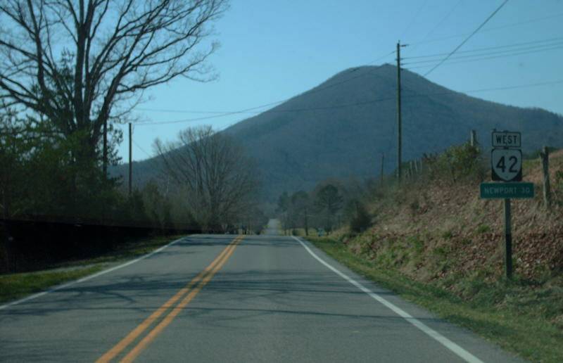
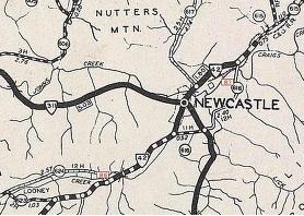
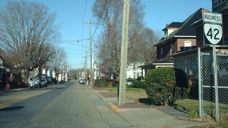
Photo: VA 42 leaving New Castle (photo by Mapmikey 3/14/08)
|
|
|
| ROUTE LOG |
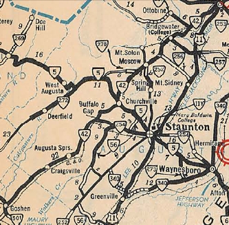
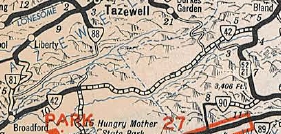
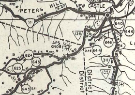
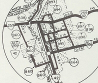
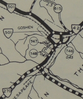
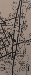
VA 91: 0 - 0 VA 16 SB: 9.59 - 9.59 VA 16 NB: 0.32 - 9.91 Bland-Smyth Line: 8.29 - 18.20 US 52 SB: 14.97 - 33.17 I-77 (Exit 52): 0.91 - 34.08 VA 98: 0.71 - 34.78 US 52 NB: 0.20 - 34.98 Giles-Bland Line: 15.63 - 50.61 VA 100: 7.95 - 58.56 GAP IN ROUTE US 460: 0 - 58.56 Craig-Giles Line: 4.10 - 62.66 VA 311: 25.33 - 87.99 GAP IN ROUTE VA 269 EB: 0 - 87.99 I-64 (Exit 29), US 60, VA 269 END: 0.18 - 88.17 Bath-Alleghany Line: 4.89 - 93.06 VA 39 WB: 11.57 - 104.63 Rockbridge-Bath Line: 5.73 - 110.36 VA 39 ALT: 2.22 - 112.58 VA 39 EB: 0.25 - 112.83 Augusta-Rockbridge Line: 5.98 - 118.81 VA 254: 15.23 - 134.04 US 250 EB: 5.25 - 139.29 US 250 WB: 0.47 - 139.76 Rockingham-Augusta Line: 13.47 - 153.23 VA 257 EB: 2.87 - 156.10 VA 42 Bus, VA 257 WB: 2.73 - 158.83 VA 290: 0.10 - 158.93 VA 42 Bus: 0.35 - 159.28 Harrisonburg-Rockingham Line: 1.90 - 161.18 US 33: 2.35 - 163.53 Rockingham-Harrisonburg Line: 2.14 - 165.67 VA 259 ALT EB: 10.53 - 176.20 VA 259 NB, VA 259 ALT END: 0.32 - 176.52 VA 259 SB: 0.62 - 177.14 VA 211: 1.39 - 178.53 Shenandoah-Rockingham Line: 3.65 - 182.18 VA 263: 8.69 - 190.87 I-81 (Exit 283): 15.72 - 206.59 US 11: 0.63 - 207.22
|
Creation: Appeared as the only VA 42 in August 1928 (CTB) as new routings:
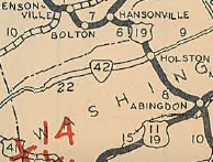
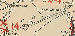
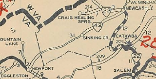
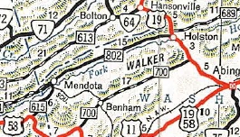
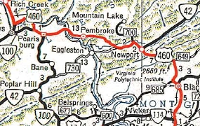
| 1. From US 19/VA 106 (now SR 876) near Holston southwest 14.25 miles to about Mendota. 2. From US 21/VA 26 (now US 52) Bland CH east 13.41 miles 3. From VA 213 (now VA 100) Poplar Hill west to the Bland County Line. 4. From VA 22 (now VA 311) New Castle west 10.42 miles. 5. From the Giles/Craig Line west to VA 23 Newport, then with VA 23 west as a duplex, then west as new routing a short distance towards Eggleston.
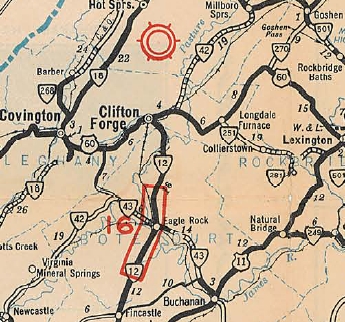
Adjustments: In Aug 1929 (CTB), piece 1 was extended west 0.8 miles and piece 4 was extended west 3 miles. In Dec 1930 (CTB), piece 2 was extended east to the Giles County Line to connect with piece 3 and was also extended west with US 21/VA 26 as duplex before heading west as new construction 2.37 miles. Also in Dec 1930, piece 4 was extended west 6.21 miles and piece 5 was extended west 6.87 miles. In June 1931 (CTB), piece 4 was extended east 1.51 miles from New Castle. In July 1932 (CTB), piece 2 was extended west 6.7 miles; piece 4 was extended west to Giles County connecting to piece 5, which was extended to connect with piece 2. Also in July 1932 a new 6th piece was created running from VA 112 (now VA 91) Broadford east 3.1 miles. In July 1933, VA 42 was assigned to a 7th piece, replacing VA 17 from US 60 (now VA 269) outside Clifton Forge to VA 4 (now US 33) Harrisonburg. The 1933 Official map also shows VA 42 replacing VA 215 from New Castle to Strom. I have never found any CTB reference putting that part of VA 215 into the system - perhaps it was based on the 1933 route log description that read as if 42 were continuous from Mendota to Harrisonburg.
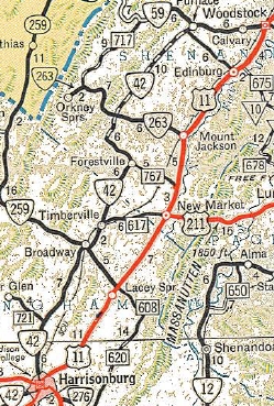
In Nov 1939 (CTB), VA 42 was rerouted west of New Castle to its current mountain ascent. The old descent was abandoned but out of New Castle became SR 644 Cumberland Ave.
In Aug 1949 (CTB), VA 42 was given its current routing through Broadway, before, it used today's VA 259 ALT east to VA 259 north.
In Dec 1953 (CTB), VA 42 was rerouted in Harrisonburg to its current routing, leaving behind bits of US 33 and US 11, plus SR 832 Edom Rd. In April 1955 (CTB), VA 42 was removed from the lengthy SR 811 between Craigsville and Augusta Springs. In Feb 1959 (CTB), VA 42 was removed from the SR 731/607 loop through Moscow. In May 1959 (CTB), the middle piece of VA 42 was truncated on its east end by 1.5 miles to end at VA 311 in New Castle, leaving behind more SR 615. In May 1960 (CTB), VA 42 was moved from Fairground Rd to W. Reservoir Rd in Woodstock. In May 1963 (CTB), VA 42 was given its bypass of Columbia Furnace, leaving behind SRs 675, 623, and 768. In May 1969 (CTB), the middle piece of VA 42 was extended west from Newport out to the new US 460 alignment, mostly over the old US 460 alignment. In Feb 1972 (CTB), VA 42 was given its bypass of Dayton, leaving behind VA 42 BUsiness. In Oct 1991 (CTB), VA 42 was given its bypass of Edom, leaving behind a lenghty SR 859. In May 2000 (CTB), VA 42 was removed from SR 844 at the VA 263 junction, which also eliminated a brief VA 263 duplex. Improvements: Upon designation only the part of VA 42 that was paved was its VA 23 (now US 460/SR 798) duplex. In 1930, VA 42 was paved on its new duplex with US 21 south out of Bland CH. In 1932, the first piece of solo VA 42 was paved, from VA 113 (now VA 91) east several miles. In 1933, VA 42 was paved on its new routing from Millboro Springs to Harrisonburg. In 1937, VA 42 was paved on its VA 100 duplex. In 1938, VA 42 was paved from New Castle east to its endpoint and also from Millboro Springs south a few miles. In 1939, VA 42 was paved a few miles east from Bland CH; a few miles west from New Castle; US 60 to Millboro Springs. In 1941, VA 42 was paved in Bland Co to past Mechanicsburg. Between 1942-44, VA 42 was paved in the Mendota area; Newport into Craig County a few miles. In 1947, VA 42 was paved from Mendota to Holston. The extension to Woodstock was paved except from between Getz Corner and Columbia Furnace. In 1948, VA 42 was paved from US 21/52 west a few miles; Mechanicsburg to VA 100; Sinking Creek to the New Castle paved portion. In 1950, VA 42 was paved from VA 16 east to the Bland line; most of western Bland Co; Sinking Creek west to paved potion from Newport. In 1951, VA 42 was paved west of VA 16; VA 16 east to Bland line is shown as not paved again; all of Bland Co paved. In 1953, all of VA 42 was shown as fully paved. VA 42 was multilaned from Broadway to Timberville in 1966. In 1970, VA 42 was multilaned from Bridgewater to Dayton. In 1972, VA 42 was multilaned from Dayton to Harrisonburg. By 1988, VA 42 was multilaned in a short segment centered around US 33. In 1989, VA 42 was multilaned from NCL Harrisonburg to about Edom. In 1991, VA 42 was multilaned from Broadway south a few miles. In 1992, VA 42 was multilaned through Harrisonburg and also on the Edom Bypass. In 1993 or 1994, VA 42 was multilaned between the Edom bypass and the piece south from Broadway. In 1997 or 1998, VA 42 was multilaned from I-81 to US 11. Posted: Fully posted; cutouts as of 2011 remain in Harrisonburg, S. Augusta Springs, and Churchville. Error US 42 shields exist in Harrisonburg and also at SR 623/768 jct in Columbia Furnace (replaced a cutout that was still there in 2008). Multiplexes: VA 16 (0.32 mi) US 52 (1.62 mi) VA 269 (0.18 mi) VA 39 (8.20 mi) US 250 (0.47 mi) VA 257 (2.73 mi) VA 259 ALT (0.32 mi) VA 259 (0.62 mi) Legislative names: Harpine Highway from Broadway to Harrisonburg (since 7-20-54) Veterans Memorial Bridge over N. Shenandoah River (since 4-16-98) Other names: Bluegrass Trail (w of VA 16); Old Wilderness Rd (VA 16 to Bland Co); W. Blue Grass Hwy (Bland Co w of US 52); South Scenic Hwy (US 52 duplex); E. Blue Grass Hwy (Bland Co e of US 52); Walkers Creek Valley Rd (Giles Co w of VA 100); Blue Grass Trail (Giles Co e of US 460); Cumberland Gap Rd (Craig Co); Main St (New Castle); Forty Two Rd (Alleghany Co); Cow Pasture River Rd (Bath Co s of VA 39); Mountain Valley Rd (VA 39 duplex in Bath Co); Maury River Rd (VA 39 duplex in Rockbridge Co); Virginia Ave (Rockbridge Co n of VA 39); Little Calf Pasture Hwy (Augusta Co s of SR 688); Craig St (Craigsville); Parkersburg Tpk (SR 688 to VA 254); Buffalo Gap Hwy (VA 254 to US 250); Scenic Hwy (US 250 to SR 809); Iron Works Rd (SR 809 to Rockingham Co); Warm Springs Pike (Rockingham Co s of Bridgewater); Main St (Bridgewater); John Wayland Hwy (Bridgewater to Harrisonburg); High St/Virginia Ave (Harrisonburg); Main St/Lee St (Broadway); Timber Way (Broadway to Timberville); Forestville Rd (Timberville and n to Shenandoah Co); Senedo Rd (Shenandoah Co); W. Reservoir Rd (Woodstock) Scenic Byway: VA 39 duplex (since 10-27-77); US 460 to VA 311 (since 5-17-90); US 52 duplex west of I-77 (since 9-17-92); VA 16 east a few miles (since 2003); Forestville to Columbia Furnace (since 2003). Comment: VA 42 is the most prominent and obvious discontinuous route in Virginia. If it weren't for the gaps VA 42 would be the longest state highway in Virginia. The routing of the gaps if they were to be filled is made clear in the traffic logs: VA 100 to SR 730 to US 460; and SR 615 from New Castle to Eagle Rock, then US 220 to Clifton Forge The gap between the original section 1 in Washington County to Broadford is made clear with the erroneous Oct 1934 Official which showed some of that gap as primary, using a duplex with US 19 north, then SR 689 to Hayters Gap, a duplex with VA 80, then SR 613 to Allisons Gap and Allisons Gap Rd south to VA 91 Saltville with a VA 91 duplex to Broadford. VA 42 is even explicitly referenced as a point of extension for VA 80 in this timeframe.
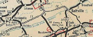
VA 42 gap route revealed 1934 Official
Previous: VA 41 |
Next: VA 43
Page last modified 28 February 2015 | ||||||||||||||||||||||||||||