< VA 25 | Home | VA 27 >
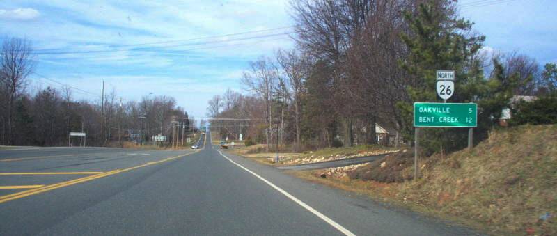
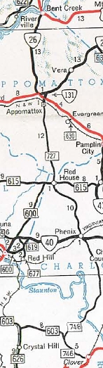
Photo: VA 26 leaving Appomattox (photo by Mapmikey 1/30/06)
|
|
|
| ROUTE LOG |
US 460, US 460 Bus, VA 24: 0 - 0 US 60: 12.83 - 12.83
|
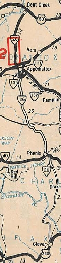
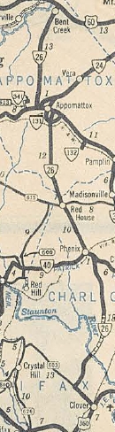
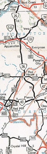
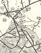
Creation: Appeared July 1933 as a renumbering of VA 307 from US 60 (now SR 717) Bent Creek to Appomattox; VA 10 along today's US 460 Business; VA 327 in Appomattox CH; and VA 306 from Appomattox south to 4.7 miles south of VA 40 Phenix. This is the 2nd VA 26.
| Adjustments: In Aug 1933 (CTB), VA 26 was extended south 3 miles. In March 1934 (CTB), VA 26 was straightened out between Appomattox and north of Oakville leaving out some abandoned segments plus SR 677 and 0.4 miles of SR 615. About 1936, VA 26 was straightened out south of Appomatox, leaving behind SR 679 (now SR 604 and SR 694 west of SR 727). In Sept 1937 (CTB), VA 26 was extended south another 3.8 miles; also a second piece of VA 26 was created running from US 360 (now VA 92) Clover west over SR 603 3.8 miles to a little short of Mt Laurel. In May 1938 (CTB), the two pieces of VA 26 were connected replacing SR 603 into Mt. Laurel, then SR 621 north into Charlotte County. In Oct 1939 (CTB), VA 26 was removed from SR 694 east of SR 727 in southern Appomattox County. Also, VA 26 was straightended through Red House leaving behind SRs 615 and 672. In Nov 1940 (CTB), VA 26 was removed from SR 704 north of Phenix. In May 1953 (CTB), VA 26 south was truncated to VA 40 Phenix leaving behind some VA 40 plus SR 746.
In May 1954 (CTB), VA 26 south was truncated to VA 24 (now SR 748) Appomattox, leaving behind lengthy SR 727, a bit of VA 131, a little US 460, and some of SR 677. In 1965, VA 26 was extended north to the rerouted US 60 at its new James River Bridge. About 1994, VA 26's south end shifted west slightly to meet the new US 460 Bypass, leaving behind SR 658 Bible Baptist Rd.
Improvements: Fully paved upon designation from Appomattox to Bent Creek plus the VA 40 duplex. In 1938, VA 26 was paved from Clover to Mt. Laurel In 1939, VA 26 was paved from Appomattox to Phenix In 1940, VA 26 was paved from Mt. Laurel to the Roanoke River and from Phenix south about halfway to the Roanoke River. Between 1942-44, VA 26 became fully paved. There are no multilane segments on VA 26. Posted: Fully posted; Multiplexes: None Legislative names: None Other names: Oakville Rd Scenic Byway: No segments Comment: VA 26 connects northern Appomattox County between US 60 and US 460. The decommissioned portions of VA 26 are very nicely aligned and it seems silly to have gone to the trouble of rebuilding these roads to be a state highway to then turn around and dump them. The 1939 VDOT report on primary system development had recommended that VA 26 be decommissioned from Appomattox to US 60. | Previous VA 26's:
1923 ROUTE LOG VA 10: 0 - 0 VA 26 END: 39 - 39 1932 ROUTE LOG NC STATE LINE: 0 - 0 US 221 NB, VA 12: 4 - 4 VA 118: 13 - 17 VA 115 WB: 6 - 23 VA 115 EB: 5 - 28 US 11, VA 10: 9 - 37 VA 115: 6 - 43 VA 42 WB: 12 - 55 VA 26Y: 4.5 - 59.5 VA 42 EB: 0.5 - 60 WV STATE LINE: 17 - 77 |
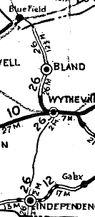
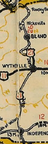
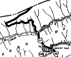
In March 1924 (CTB), VA 26 was extended south as new primary routing from Wytheville 2 miles. Also, VA 26 was extened north as new primary routing 2 miles towards Bastian. Also in March 1924, a separate piece of VA 26 was born running 2 miles north from VA 12 (now US 58) Independence. In Sept 1924 (CTB), VA 26 was rerouted on Walker Mountain to follow US 52's general routing over to Bland C.H. In Jan 1925 (CTB), the southern piece of VA 26 was extended from Independence south to the NC Line; the northern piece was extended north 8.5 miles. In Dec 1925 (CTB), VA 26 was extended north to the West Virginia line, while the lengthy gap between Independence and Wytheville was also added to the primary system. This was done outside the normal mileage allocation to conform to the interstate numbering system approved by the Department of Agriculture. In late 1926, US 21 was added to the entirety of VA 26. About 1932, VA 26 was removed from SR 628 in Rocky Gap. In July 1933, VA 26 was dropped from US 21.
| ||||||||||||||||||

Previous: VA 25 |
Next: VA 27
Top | Virginia Hwy Index
Home
Page last modified 28 February 2015