< US 30 | Home | US 35 >
|
|
|
| ROUTE LOG |
OH STATE LINE: 0 - 0 WV 68: 0.6 - 0.6 WV 2 SB: 0.5 - 1.1 I-77 NB (exit 146), WV 2 NB: 2.3 - 3.4 I-77 NB (exit 138), WV 62: 8.0 - 11.4 Roane-Jackson Line: 13.2 - 24.6 WV 14: 12.4 - 37.0 US 119 SB: 0.3 - 37.3 Calhoun-Roane Line: 7.7 - 45.0 WV 16 SB: 6.6 - 51.6 WV 16 NB: 1.7 - 53.3 Gilmer-Calhoun Line: 6.6 - 59.9 WV 5 WB: 16.7 - 76.6 WV 5 EB: 1.1 - 77.7 WV 47: 9.0 - 86.7 Lewis-Gilmer Line: 0.2 - 86.9 US 19 SB: 17.1 - 104.0 US 19 NB: 0.1 - 104.1 I-79 (exit 99), US 48 BEGIN: 2.7 - 106.8 Upshur-Lewis Line: 7.1 - 113.9 US 119 NB, WV 20: 5.1 - 119.0 Randolph-Upshur Line: 14.8 - 133.8 US 250 NB, WV 92 NB: 1.4 - 135.2 WV 92 SB: 3.4 - 138.6 US 48 EB, US 219 NB: 3.4 - 142.0 WV 92 NB: 1.7 - 143.7 US 219 SB, WV 55 WB, WV 92 SB: 1.1 - 144.8 WV 32: 22.4 - 167.2 Pendleton-Randolph Line: 3.9 - 171.1 WV 28 NB, WV 55 EB: 8.3 - 179.4 WV 28 SB: 10.9 - 190.3 US 220 NB: 12.9 - 203.2 US 220 SB: 0.6 - 203.8 VA STATE LINE: 18.7 - 222.5
|
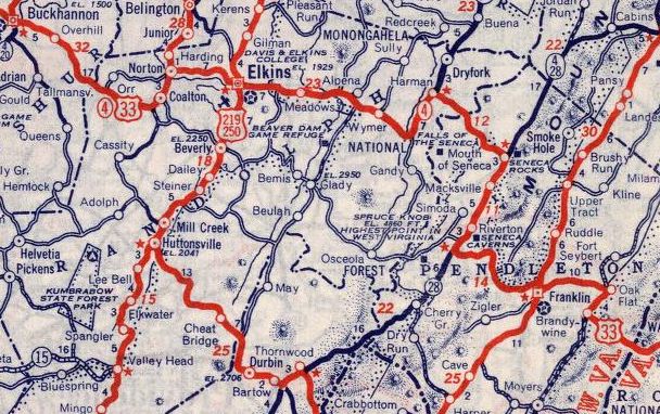
Creation: A US route from Charleston WV to Richmond IN was first proposed in May 1929 (AASHO). US 33 was approved by AASHO in September 1937 to be posted Jan 1, 1938. In West Virginia US 33 replaced WV 62 from Mason to Evans and WV 5 from Evans through Ripley, Spencer, Weston, Buckannon, Elkins and Franklin into Virginia.
|
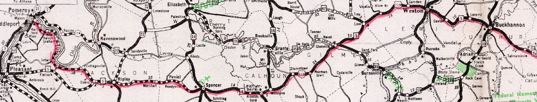
WV 62 and WV 5 from Mason through Buckannon 1935 Official
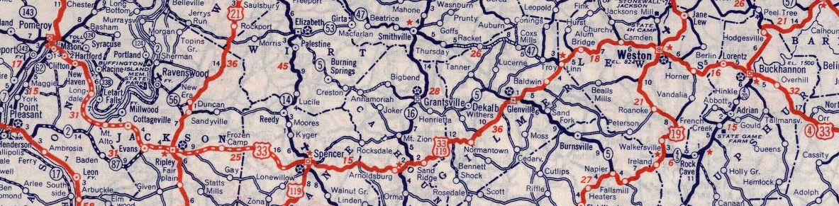
US 33 replaces WV 62 and WV 5 1939 Rand McN
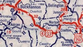
Adjustments: Between 1938-46, US 33 was removed from CR 5/24 Old Golf Course Rd east of Spencer In 1942, US 33 was rerouted from Pumpkintown to Norton to avoid Coalton (now Womelsdorf), leaving behind CR 53.
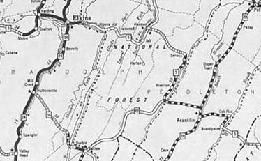
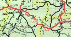
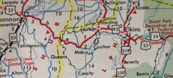
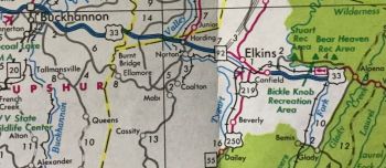
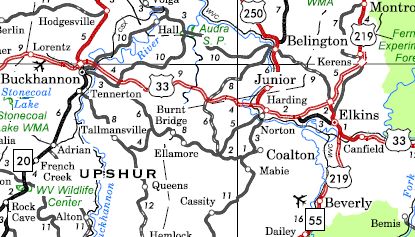
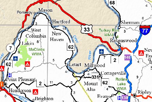
Between 1947-49, US 33 was removed from CR 33/11 (now CR 19) Layne St in New Haven, which is now cutoff by the power plant. The old road met current WV 62 just short of CR 9. In 1955 (bridge date), US 33 was given a newly constructed alignment around Harman, leaving behind CR 32/5 Main St and CR 33/16 Mott St. In 1956 (bridge date), US 33 was removed from CR 33/8 at Judy Gap In 1959 (bridge date), US 33 was removed from West Main St into Spencer About 1960, US 33 was removed from CR 33/17 and CR 5 from Cottageville to Evans and WV 87 from Evans to Rollins Lake; also nearby CR 33/10 Battenfarm Rd. Between 1958-62, US 33 was removed from CR 33/2 Circle Heights east of Weston; CR 33/1 through McGuire Park; CR 12/5 Lady Slipper Dr loop near Buckhannon In 1963 (bridge date), US 33 was removed from CR 33/3 through Gaston and Homer No later than 1966, US 33 was removed from CR 9/6 in Riverton. My guess is that US 33 was removed from CR 33/21 Old Rte 33 west of I-77 in the late 1960s. In the early 1970s (WVDOT plans), US 33 was removed from Arlie Ln, CR 3/7 and CR 3/8 at Oak Flat In November 1975 (AASHO), US 33 was rerouted between mt Alto and Cottageville by following WV 2 northeast through Millwood, then southeast replacing WV 44 back to Cottageville. The old route became WV 331. In 1976, US 33 was removed from CR 33/4 Hidden Ln west of Lorentz; CR 12 through Lorentz; also removed from CR 33/8 east of Elkins and placed on new construction as part of Appalachian Corridor H (later Corridor H would be reworked to not use any of US 33's general alignment east of Elkins). In 1989 (approved by AASHTO in June 1992), US 33 was removed from the rest of CR 12 west of Buckhannon and also placed on the freeway bypass around Buckhannon itself, continuing on newly constructed route to CR 3 Heavener Grove. The old route east of Buckannon became LSR 151. In April 1994 (AASHTO), US 33 was placed on more newly constructed routing from Heavener Grove to today's WV 92 split west of Elkins, leaving behind more LSR 151 plus CR 151/4. About 2002, US 33 was removed from WV 92 west of Elkins and placed on more new construction plus added to US 219 to get back to Elkins.
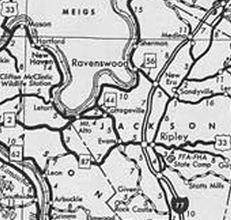
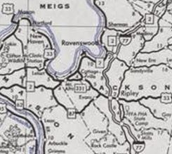
In May 2004 (AASHTO), US 33 was rerouted away from the Ohio River crossing at Mason to instead cross at Ravenswood, replacing WV 338 across the bridge and WV 68 south a short distance before following WV 2 to I-77. US 33 then followed I-77 to the Ripley exit to rejoin the route east towards Spencer. The old route became WV 62 Spur across the bridge to Mason and an extended WV 62 to I-77 Ripley.
Improvements: Fully paved upon inception except from Graham Station to nearly Spencer; Judy Gap to Virginia US 33 was paved from Ripley to Spencer; all but a few miles east of Judy Gap on to Virginia by 1942 US 33 was paved from Judy Gap east to the previous pavement between 1944-46. US 33 was paved from Graham Station to Letart between 1947-50. US 33 was paved from Letart to Ripley between 1955-58. US 33 is multilaned only on its Corridor H related alignments, plus its overlays with WV 2 and I-77. Comment: US 33 is still a fairly slow travel path from Ripley to I-79; Judy Gap to Virginia is pretty rugged. | |||||||||||||||
Previous: US 30 |
Next: US 35
Top | West Virginia Hwy Index
Home
Page last modified 13 May 2022