ROUTE LOG
TN 103 BEGIN: 0 - 0
TN 181: 1.6 - 1.6
TN 78: 6.7 - 8.3
|
|
Creation: Appeared in 1929 running as it does today. This had been part of TN 20 earlier in the 1920s.
Adjustments: If TN 103 ever used the now-primitive Banks St loop just east of Miston it stopped doing so by 1938.
Posting: Not posted west of TN 181 in any way. Posted as secondary elsewhere.
Secret US Route Overlay: None
Comment: From TN 181 west to Tennemo Levee Rd is barely paved and west of there TN 103 is dirt, whose path becomes less discernible every time the Mississippi River floods there. Shown as paved on all maps though.
|
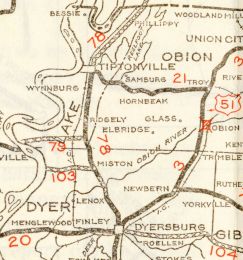
TN 103
1932 Official
|