< TN 98 | Home | TN 100 >
|
|
|
| ROUTE LOG |
US 64, TN 15: 0 - 0 Lewis-Wayne Line: 14.1 - 14.1 TN 20 EB: 14.5 - 28.6 TN 48 SB: 0.3 - 28.9 US 412 WB, TN 20 WB, TN 48 NB: 0.4 - 29.3 Natchez-Trace Parkway: 8.2 - 37.5 Maury-Lewis Line: 6.8 - 44.3 TN 166: 2.9 - 47.2 US 43, US 412 EB, US 412 Bus BEGIN, TN 6: 10.2 - 57.4 TN 50 WB: 2.1 - 59.5 TN 50 EB: 1.1 - 60.6 TN 243: 1.1 - 61.7 US 31 SB, TN 7 SB: 0.6 - 62.3 US 31, US 412 WB, US 412 Bus END, TN 6, TN 7 NB: 1.8 - 64.1 I-65 (exit 46), US 412 END: 7.2 - 71.3 US 431 NB, TN 106 NB: 4.0 - 75.3 US 431 SB, TN 106 SB: 0.8 - 76.1 Marshall-Maury Line: 0.2 - 76.3 TN 272: 3.6 - 79.9 US 31 ALT SB, TN 11 SB: 3.6 - 83.5 TN 270: 0.2 - 83.7 US 31 ALT NB, TN 11 NB: 3.0 - 86.7 Rutherford-Marshall Line: 4.2 - 90.9 US 41 ALT SB, TN 16 SB: 2.3 - 93.2 US 41 ALT NB, TN 16 NB, TN 269 WB: 1.0 - 94.2 TN 269 EB: 5.4 - 99.6 I-24 (exit 80): 10.4 - 111.0 TN 96 WB: 1.3 - 111.3 US 41 NB, US 70S WB, US 231 NB, TN 1 WB, TN 10 NB, TN 96 EB: 0.6 - 111.9 US 231 SB, TN 10 SB: 0.7 - 112.6 US 70S EB, TN 1 EB, TN 2 BEGIN: 0.5 - 113.1 US 41 SB, TN 2 SB: 0.1 - 113.2 Cannon-Rutherford Line: 16.3 - 129.5 TN 64: 1.4 - 130.9
|
Creation: Appeared in 1927 or 1928 running from TN 50 Columbia west to Hampshire.
| Adjustments: In 1929, TN 99 west was extended 3 miles to the Lewis County line.
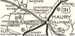
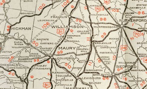
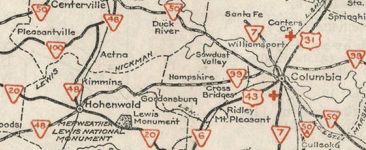
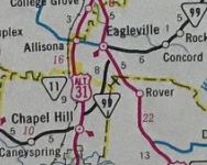
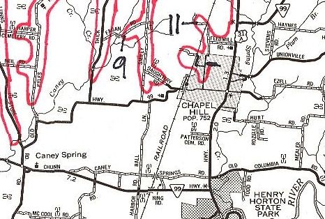
In 1931 or 1932, TN 99 east was extended with TN 50 to TN 6 through Columba then extended east to Chapel Hill, then with TN 11 north to Allisona, then east as new routing to Eagleville then replaced TN 51 east to end at TN 96 Murfreesboro. In 1939 or 1940, TN 99 west was extended to TN 48 Hohenwald In 1941 (bridge dates), TN 99 was straightened out in the Cross Bridges area west of Columbia. This left behind a small bit of Booker Ridge Rd and abandoned routing In 1948 (bridge dates), TN 99 was removed from Taylors Store Rd/Old State Rd in the Hampshire area; also a bit of Dry Fork Rd, abandoned routing, McLellan Rd/Ridgetop Rd, John Sharp Rd and abandoned routing to the Gordonsville area. About this timeframe I believe TN 99 was also removed from abandoned routing/Black Rd; Old 99 Cir; Gray Rd and Swan Ave through Blondy to TN 48 Hohenwald. In the mid-50s (by 1956), TN 99 was removed from the courthouse square in Columbia, N Main St, E 5th St and Riverside Dr. TN 99 now follows modern US 31. Between 1960-64, TN 99 was rerouted at Chapel Hill to go northeast to Eagleville more directly. The road to Allisonia remained US 31A and the road from Allisonia to Eagleville was removed from the state hghway system (now it is TN 269).
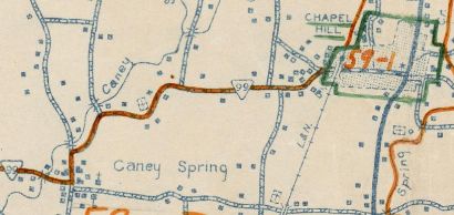
In 1969 (bridge date), TN 99 was removed from Rox Farms Dr and abandoned routing over Caney Creek in Caney Spring; also removed from Old Hwy 99 from Caney Spring to Chapel Hill and placed on caney Springs Rd and new construction to meet US 31A at Henry Horton State Park.
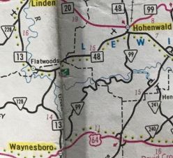
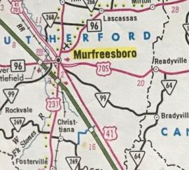
In 1970, TN 99 was removed from Old Salem Hwy and Kings Hwy within Murfreesboro and placed on New Salem Rd to end at TN 96 Bridge St. In 1972, TN 99 east was extended to the new TN 96 Old Fort Pkwy in western Murfreesboro. It is possible the 1970 action didn't occur until this step. In the late 70s, TN 99 was removed from both segments of Old Bear Creek Pike east of US 31; also removed from Old Hwy 99 west of I-65. In 1983, TN 99 was extended in both directions: south with TN 48 and TN 20 through Hohenwald, then south and west to US 64 Waynesville; east with TN 96 and US 41 through Murfreesboro, then east to TN 64 Bradyville
In 1989 (bridge date), TN 99 was removed from Old Salem Rd west of Murfreesboro.
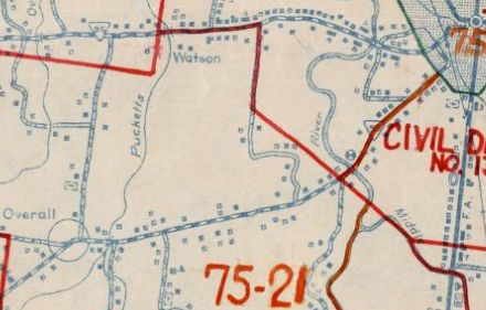
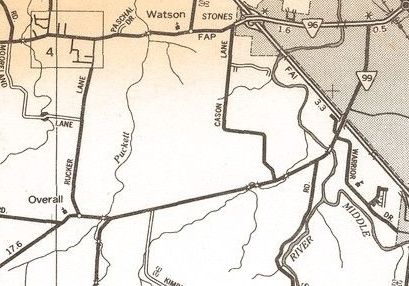
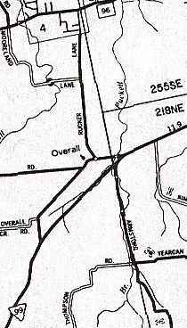
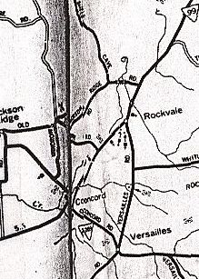
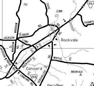
In 1992, TN 99 was removed from Rockvale Rd through Concord and Rockvale
About 2011, TN 99 was rerouted at Eagleville to leave US 41A south of town on new construction. The old route was more US 41A and Old Hwy 99.
Posting: Posted as primary from Hohenwald to Henry Horton SP and the rest is secondary. The overlays with TN 20, US 431 and US 41A are fully posted; US 31A is posted with TO assemblies. The overlays with US 412, US 412 Bus, TN 96 and US 41 are unposted. Secret US Route Overlay: US 412, west segment (28.3 mi) US 412 Bus (4.9 mi) US 412, east segment (7.2 mi) Comment: Blown off by I-24 until an interchange was built in 2007. The segment between Waynesboro and Hohenwald is especially tortuous. There are other paved ways to make this connect ion that are shorter. Even TN 13 to Tn 48 is faster, albeit a couple miles longer. | |||||||||||||||||||||