< TN 77 | Home | TN 79 >
|
|
|
| ROUTE LOG |
TN 104: 0 - 0 US 51, TN 3: 1.6 - 1.6 I-155 (exit 13), US 412: 0.7 - 2.3 TN 182: 2.6 - 4.9 TN 103: 4.6 - 9.5 Obion-Dyer Line: 4.0 - 13.5 Lake-Obion Line: 1.0 - 14.5 TN 79: 0.6 - 15.1 TN 21, TN 22 SB: 10.0 - 25.1 TN 22 NB: 0.5 - 25.6 TN 212: 1.4 - 27.0 TN 213: 5.7 - 32.7 KY STATE LINE: 3.0 - 35.7
|
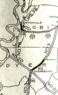
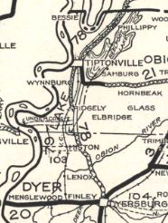
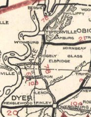
Creation: An original state route. In 1924 it ran from TN 20 (now TN 103) near Miston north through Tiptonville to Kentucky.
|
Adjustments: There are some zig-zag possibilities for the original path of TN 78, but the current straight path in the northwest Dyer County and Obion County areas was in place by 1926 (bridge date) and the straight path northeast of Tiptonville was in place by 1928 (bridge date). In 1928 or 1929, TN 78 was extended south replacing TN 20 to end at the new TN 20 (now TN 104) Dyersburg. In 1930, TN 78 was removed from Tiptonville-Ridgely Rd and placed on the current routing east of the railroad. Also in 1930, there may have been an attempt by Kentucky to get some portion of TN 78 to be designated as US 268. By 1938, TN 78 was removed from Harness Rd/Burnt Mill Rd which no longer crosses the Obion River.
Posting: Posted as secondary routing south of US 51; primary routing everywhere else Secret US Route Overlay: None Comment: TN 79 provides the main access to Lake County from the south | ||||||||