< TN 9 | Home | TN 10A | TN 11 >
|
|
|
|
| ROUTE LOG |
AL STATE LINE: 0 - 0 TN 275: 2.3 - 2.3 TN 110: 6.9 - 9.2 US 64 WB, US 431 NB, TN 15 WB, TN 273: 1.4 - 10.6 US 64 EB, US 64 Bus, TN 15 EB, TN 50: 1.7 - 12.3 Moore-Lincoln Line: 12.3 - 24.6 TN 129 EB: 0.5 - 25.1 TN 129 WB: 0.2 - 25.3 Bedford-Moore Line: 1.5 - 26.8 TN 64 WB, TN 130 WB: 9.4 - 36.2 US 231 NB, US 231 Bus Begin, TN 64 EB, TN 130 EB, TN 387: 0.7 - 36.9 TN 82 SB: 0.3 - 37.2 US 41 ALT, TN 16: 0.1 - 37.3 US 231 SB, US 231 Bus END, TN 387: 0.5 - 37.8 TN 437: 2.2 - 40.0 TN 82 NB: 4.2 - 44.2 Rutherford-Bedford Line: 4.3 - 48.5 TN 269 EB: 4.0 - 52.5 TN 269 WB: 0.4 - 52.9 I-24 (exit 81): 6.6 - 59.5 US 41 SB, US 70S EB, TN 1 EB, TN 99 EB: 2.1 - 61.6 US 41 NB, US 70S WB, TN 1 WB, TN 96 WB, TN 99 WB: 0.7 - 62.3 TN 96 EB: 1.0 - 63.3 TN 268: 3.4 - 66.7 TN 266: 2.8 - 69.5 Wilson-Rutherford Line: 4.3 - 73.8 TN 452: 0.9 - 74.7 TN 265: 5.8 - 80.5 I-40 (exit 238): 5.8 - 86.3 US 70 Bus, TN 24: 1.9 - 88.2 US 70, TN 26: 0.3 - 88.5 Trousdale-Wilson Line: 6.3 - 94.8 US 231 NB, TN 25 WB, TN 376: 6.2 - 101.0 TN 141 NB: 5.6 - 106.6 TN 141 SB: 0.3 - 106.9 TN 25 EB: 2.8 - 109.7 Macon-Trousdale Line: 4.7 - 114.4 TN 52: 6.9 - 121.3 TN 261 SB: 0.5 - 121.8 TN 261 NB: 0.6 - 122.4 KY STATE LINE: 8.7 - 131.1
|
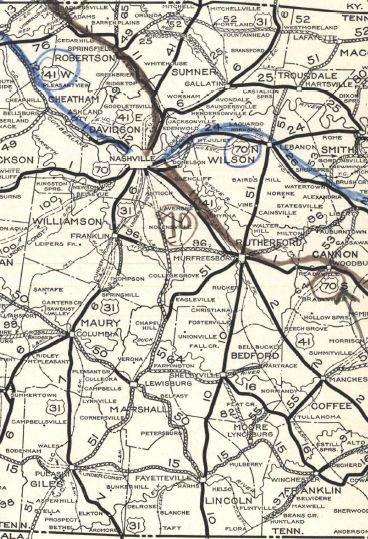
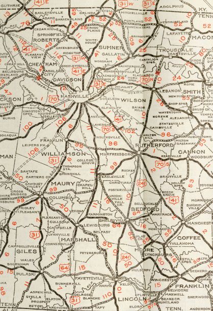
Creation: Appeared in 1923 as an original state highway, running from TN 1-51 (xxx) Murfreesboro south through Shelbyville and Fayetteville into Alabama headed for Huntsville.
| Adjustments: Around the time TN 10 was established it was removed from Stoneboro Rd in northern Lincoln County. If TN 10 ever used Mt Herman Rd/Hawthorne Rd in southern Bedford County it also stopped at this time. In May 1930 (AASHO), US 241 was added to the entirety of TN 10 at that time. In 1931 or 1932, TN 10 was extended north, replacing TN 51 through Lebanon, Hartsville and Lafayette before heading into Kentucky. TN 10 may have briefly used Broadway/Halltown Rd/New Harmony Rd from Hartsville to Sullivan, Old Hwy 52/Brattontown Cir from Sullivan to Brattontown, a bit of TN 52, and Church St into Lafayette.
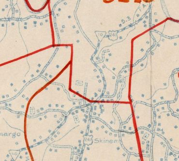
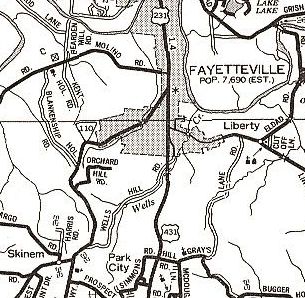
It appears TN 10 was removed from Old Lebanon Pike by the VA Center Murfreesboro in the 1940s. About 1947, TN 10 was removed from Old Huntsville Rd south of Fayetteville, the northern part becoming part of TN 110.
About 1948, TN 10 was removed from Old lafayette Rd east of Hartsville; Old hwy 10/Rock Crusher Rd and Hillsdale Cir at Hillsdale. By 1951, TN 10 was removed from Old Chestnut Ridge Rd north of TN 129. In 1952, TN 10 was removed from Old 25 Loop east of US 231 and Old Hwy 25/Main St through Hartsville. Between 1940-53, TN 10 was removed from Meador Rd/Hansetown Rd loop at the Kentucky State Line. In 1955, TN 10 was removed from Old Hunters Point Pike north of Lebanon and Old Hunters Point Point Pike N at Hunters Point In 1956, TN 10 was removed from Old Lebanon Rd through Silver Hill; Old Murfreesboro Rd West segments near Vine In 1959, TN 10 was removed from the lengthy Old Murfreesboro Rd through Holloway and Forktown which becomes Maple St into Lebanon plus Market St It is unclear when TN 10 was rerouted to its current path through Murfreesboro but it was by 1960. Broad St was constructed in the mid-1950s, but Memorial Blvd may not have built until later. TN 10's original routing was: Church/Vine/Spring/College/Maple. It is unclear if it kept this routing until around 1960 or if an interim routing was created by the opening of Broad St.
It appears that in the 1960s, TN 10 was rerouted onto North Cannon Blvd in Shelbyville instead of a now-removed street east to and around the courthouse to Main St. About 1972, TN 10 was given its bypass around the east of Fayetteville, leaving behind Main St, College St, Mulberry Ave and Shelbyville Hwy. Posting: TN 10 is primary throughout except north of Lafayette, which is secondary. TN 10 is not posted south of the TN 25 split east of Hartsville Secret US Route Overlay: US 231 I (36.9 mi) US 231 Bus (0.9 mi) US 231 II (63.2 mi) Comment: The lack of TN 10 posting with TN 25 is weird since TDOT considers the route TN 10. | |||||||||
Previous: TN 9 |
Next: TN 10A | TN 11
Top | Tennessee Hwy Index
Home
Page last modified 9 July 2021