< SC 5 | Home | SC 7 >
|
|
|
| ROUTE LOG |
US 76: 0 - 0 Lexington-Richland Line: 1.9 - 1.9 SC 60: 2.4 - 4.3 US 378 EB: 5.1 - 9.4 US 378 WB: 0.3 - 9.7 US 1: 0.7 - 10.4 I-20 (exit 55): 1.8 - 12.2 SC 602: 3.3 - 15.5 SC 302 NB: 3.6 - 19.1 SC 302 SB: 1.6 - 20.7 US 321: 10.2 - 30.9 Calhoun-Lexington Line: 6.3 - 37.2 US 21 NB: 4.7 - 41.9 US 21 SB, SC 172: 1.7 - 43.6 I-26 (exit 136): 1.4 - 45 US 176 WB: 3.4 - 48.4 US 176 EB: 0.5 - 48.9 US 601: 3.3 - 52.2 SC 33: 8.7 - 60.9 Orangeburg-Calhoun Line: 4.2 - 65.1 SC 267 NB: 1.2 - 66.3 SC 47: 1.2 - 67.5 SC 267 SB: 2.2 - 69.7 I-95 (exit 98), US 15, US 301: 5.0 - 74.7 SC 6 CONN: 1.6 -76.3 SC 310: 1.9 - 78.2 SC 210: 1.4 - 79.6 SC 45 WB: 4.7 - 84.3 Berkeley-Orangeburg Line: 6.2 - 90.5 SC 45 EB: 4.5 - 95.0 SC 311: 7.0 - 102.0 US 17 ALT: 11.7 - 113.7 US 52: 1.0 - 114.7
|
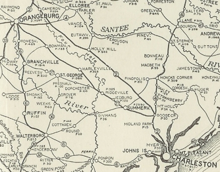
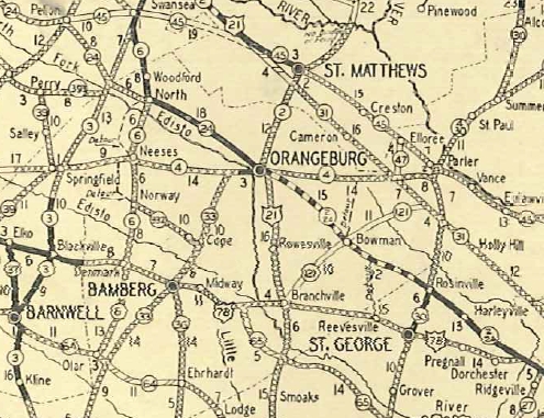
Creation: An original state route that originally ran from SC 2 (now US 78 King St) Charleston west to Walterboro, then north via Ruffin and Branchville to end at SC 2 (now US 178 Bus) Orangeburg. This is the only SC 6.
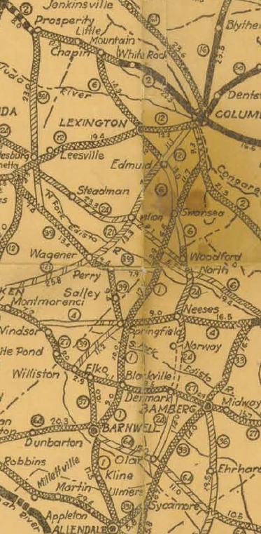
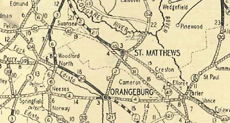
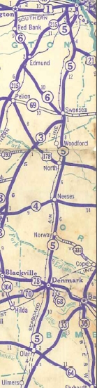
| Adjustments: In 1925 or 1926, SC 6 was extended with SC 2 into Orangeburg, then northwest as new primary routing to North, then north through Swansea and Lexington to end at SC 2 (now US 76) Chapin.
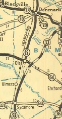
By 1926, SC 6 was removed from S-15-67/S-15-24 between Ruffin and Smoak and placed on modern US 21; also SC 6 was removed from Kristin Ave/S-15-371/S-15-41 In 1927 (bridge date), SC 6 was removed from Old Jacksonboro Rd between S-10-40 Parkers Ferry west to the Edisto River. In 1928, SC 6 south was truncated to Orangeburg. Orangeburg to south of Ruffin became US 21; east to Walterboro became SC 64; Walterboro to Charleston became US 17. Today this is 21 Business; US 21 to Rowesville; S-38-117 to Branchville (it is unclear if SC 6 was moved to modern US 21 before 1928 or not); US 21 south to SC 64; SC 64 east to Jacksonboro except: S-15-208 Dorsey Rd northwest of Walterboro, SC 64 Business through Walterboro; US 17 to Parkers Ferry; S-10-40; SC 174; SC 162; US 17 to Charleston; S-10-3 to King St. As best I can tell, SC 6 never used the lengthy Old Jacksonboro Rd from Osborn east past today's SC 165.

SC 6 truncated to Orangeburg 1928 Standard Draft Between 1927-29, SC 6 was removed from Peachtree Rock Rd south out of Edmund.
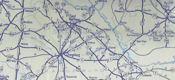
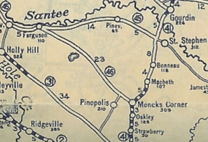
In 1936 or 1937, SC 6 was shown as a projected road from SC 64 Olar south to SC 33 (now US 301) near Ulmers. In 1939, SC 6 was rerouted at Swansea to replace SC 45 east through St Matthews to Eutawville, then replaced SC 46 east to Moncks Corner.
The route from Swansea south to Olar was renumbered as SC 5 (now US 321).
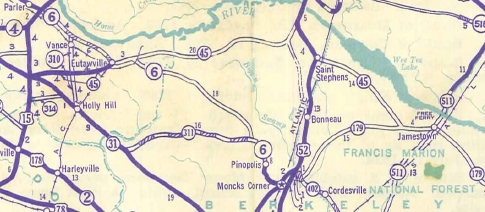
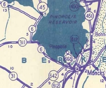
In 1942, SC 6 was rerouted around the newly built Pinopolis Reservoir (Lake Moultrie) replacing parts of SC 260 and SC 311 plus new construction. The road between Pinopolis and Moncks Corner became SC 668 (now S-8-5).
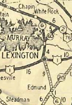
About 2018, SC 6 was placed on one-way splits in Lexington. WB used the original route of Lake Dr. EB now uses Church St and Maiden Ln. This change also eliminated a posted SC 6 West Truck for US 1 SB traffic that followed US 1 south to US 378 back to SC 6. Improvements: SC 6 was paved from Charleston over to around Ravenel by 1923. In 1927, SC 6 was paved from Rowesville to Orangeburg. In 1928, the remaining SC 6 was all unpaved. In 1929, SC 6 was paved from Swansea to North. In 1931, SC 6 was paved from Lexington to Ballentine. In 1932, SC 6 was paved from North to Denmark. In 1934, SC 6 was paved from Lexington to Edmund and also from Denmark to Olar. In 1937 SC 6 became fully paved from Olar to Ballentine. In 1939 after the major SC 6 rerouting, SC 6 was paved from Ballentine to Swansea; US 21 (current US 176) to Santee; Pinopolis to Moncks Corner. In 1942, SC 6 was paved from Santee to Eutawville. Between 1943-46 SC 6 was paved from Swansea to St. Matthews and also from SC 311 to Moncks Corner. In 1949 SC 6 was paved from Eutawville to the Berkeley County Line. The remaining piece of SC 6 from the Orangeburg-Berkeley Line to SC 311 was paved in 1950. SC 6 was 4-laned on its US 378 duplex in 1978. In 2009, SC 6 was multilaned from US 378 to SC 60. In 2012, SC 6 was multilaned from SC 602 to a little north of I-20 Comment: SC 6 bears no resemblance to its original routing anymore. There is a posted SC 6 TRUCK in Moncks Corner that uses US 17 ALT and US 52. SC 6 bears the distinction of being underneath parts of 2 lakes; it crosses the Lake Murray Dam directly and is often very close to the Lake Moultrie southern berm. Thanks to Dave Darby for historical input on SC 6. | ||||||||||||||||
Previous: SC 7 |
Next: SC 8
Top | South Carolina Hwy Index
Home
Page last modified 9 February 2024