< SC 310 | Home | SC 312 >
|
|
|
| ROUTE LOG |
US 176: 0 - 0 SC 6: 9.2 - 9.2
|
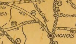
Creation: SC 311 appeared in 1925 or 1926 as new primary routing, running from SC 31 (now US 176) east through Cross and Chicora before ending at SC 46 (now under Lake Moultrie) at Hog Swamp. This is the only SC 311.
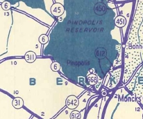
| Adjustments: In 1942, SC 311 east was truncated to its current ending at SC 6. From there to Chicora became part of SC 6, while the easternmost 2 miles or so became underwater at Lake Moultrie, though about half of the western side of this was still mostly above the water line up through at least 1972, per Historicaerials.com. Also SC 311 used a mostly abandoned loop closer to today's shoreline west of Chicora and abandoned Crepe Myrtle Path. Between 2008-11 (GMSV), the east end of SC 311 was reconfigured so that instead of 311 being continuous to SC 6 east, SC 311 now must turn north over old S-8-135 to meet SC 6. Improvements: SC 311 was paved in 1949; no multilane sections exist. Comment: SC 311 is a useful short cut from Moncks Corner to Orangeburg...
| |||||||
Previous: SC 310 |
Next: SC 312
Top | South Carolina Hwy Index
Home
Page last modified 19 June 2015