< I-79 | Home | I-85 >
I-381 | I-581
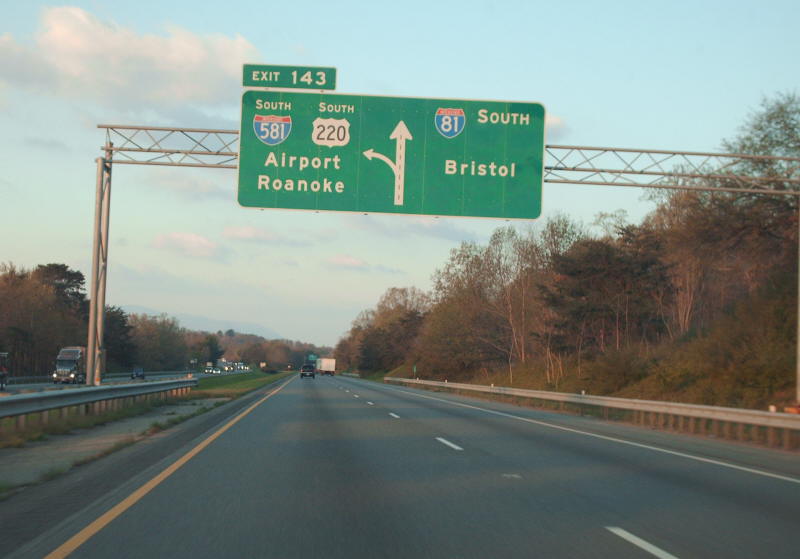
Photo: I-81 north approaching I-581 near Roanoke (photo by Mapmikey 4/13/07)
|
|
|
| ROUTE LOG |
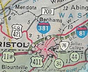
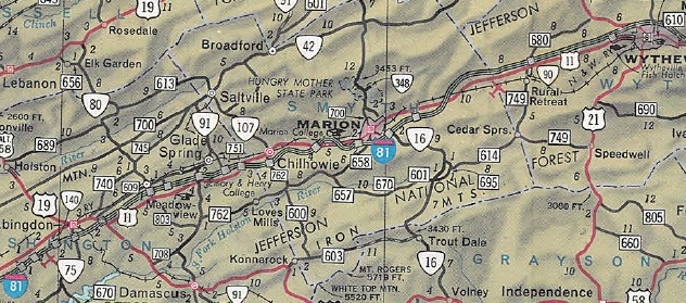
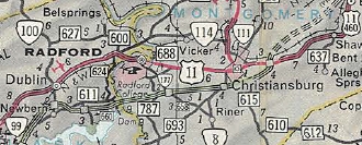
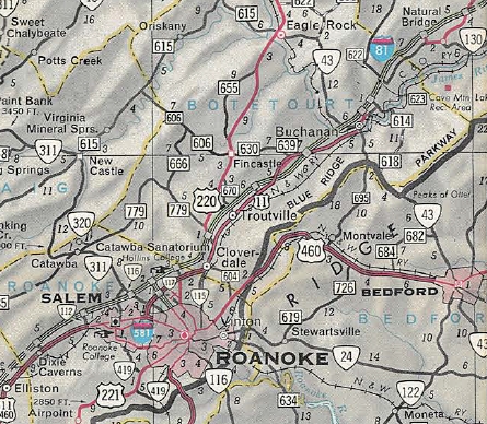
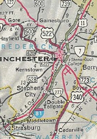
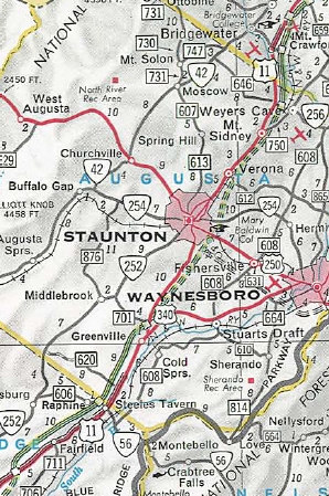
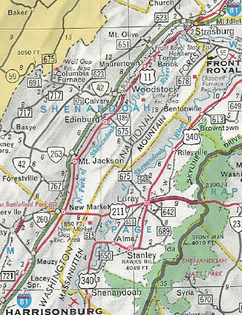
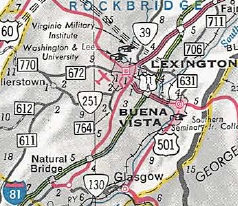
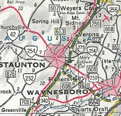
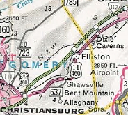
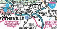
TN STATE LINE: 0 - 0 Bristol-Washngton Line: 0.65 - 0.65 EXIT 1 - US 58 WB, US 421: 0.61 - 1.26 EXIT 3 (old 2) - I-381 (exit 1): 2.44 - 3.70 EXIT 5 (old 3) - US 11, US 19: 1.39 - 5.09 EXIT 7 (old 4) - Old Airport Rd: 2.13 - 7.22 Washington-Bristol Line: 0.93 - 8.15 EXIT 10 (old 5) - F-310: 3.84 - 11.99 EXIT 13 (old 6) - SR 611: 0.99 - 12.98 EXIT 14 (old 7) - VA 140: 2.00 - 14.98 EXIT 17 (old 8) - US 58 ALT, VA 75: 2.07 - 17.05 EXIT 19 (old 9) - US 11, US 58 EB: 1.06 - 18.11 EXIT 22 - SR 704: 4.05 - 22.16 EXIT 24 (old 10) - VA 80: 2.66 - 24.82 EXIT 26 (old 10A) - SR 737: 1.52 - 26.34 EXIT 29 (old 11) - VA 91: 2.97- 29.31 EXIT 32 (old 12) - US 11: 2.68 - 31.99 Smyth-Washington Line: 2.31 - 34.30 EXIT 35 (old 13) - VA 107: 1.05 - 35.35 EXIT 39 (old 14) - US 11: 3.89 - 39.24 EXIT 44 (old 15) - US 11: 4.07 - 43.31 EXIT 45 (old 16) - VA 16: 1.46 - 44.77 EXIT 47 (old 17-17A) - US 11: 2.09 - 46.86 EXIT 50 - SR 622: 2.99 - 49.85 EXIT 54 (old 18) - SR 683: 3.98 - 53.83 Wythe-Smyth Line: 2.80 - 56.63 EXIT 60 (old 19) - VA 90: 3.07 - 59.70 [NB only] EXIT 67 (old 20) - US 11: 7.09 - 68.79 EXIT 70 (old 21) - US 21, US 52 NB: 2.03 - 70.82 EXIT 72 (old 22) - I-77 NB (exit 40): 2.27 - 73.09 EXIT 73 (old 23) - US 11 SB: 0.82 - 73.91 EXIT 77 (old 24) - F-326: 3.14 - 77.05 EXIT 80 (old 25) - US 52 SB, VA 121: 2.61 - 79.66 EXIT 81 (old 26) - I-77 SB (exit 32): 1.44 - 81.10 EXIT 84 (old 27) - SR 619: 2.31 - 83.41 EXIT 86 (old 28) - SR 618: 1.99 - 85.40 Pulaski-Wythe Line: 1.44 - 86.84 EXIT 89 (old 29) - US 11 NB, VA 100 SB: 2.82 - 89.66 EXIT 92 (old 30) - SR 658: 2.11 - 91.77 EXIT 94 (old 31) - VA 99: 1.67 - 93.44 EXIT 98 (old 32) - VA 100 NB: 4.35 - 97.79 EXIT 101 (old 33) - SR 660: 2.59 - 100.38 Montgomery-Pulaski Line: 4.00 - 104.38 EXIT 105 (old 34) - VA 232: 0.49 - 104.87 EXIT 109 (old 35) - VA 177: 3.81 - 108.68 EXIT 114 (old 36) - VA 8: 5.12 - 113.80 EXIT 118 - US 460 WB: 3.10 - 116.90 EXIT 118C (old 37) - US 11, US 460 EB, US 460 Bus: 0.88 - 117.78 EXIT 128 (old 38) - SR 603: 9.99 - 127.77 Roanoke-Montgomery Line: 2.22 - 129.99 EXIT 132 (old 39) - SR 647: 2.06 - 132.05 Salem-Roanoke Line: 4.37 - 136.42 EXIT 137 (old 40) - VA 112: 0.20 - 136.62 Roanoke-Salem Line: 0.22 - 136.84 EXIT 140 (old 40A) - VA 311: 2.71 - 139.55 EXIT 141 (old 41) - VA 419: 1.64 - 141.19 EXIT 143 (old 42) - I-581 (exit 1), US 220 SB: 2.48 - 143.67 EXIT 146 (old 43) - VA 115: 2.34 - 146.01 Botetort-Roanoke Line: 0.84 - 146.85 EXIT 150 (old 44) - US 220 NB, VA 220 ALT: 3.27 - 150.12 EXIT 156 (old 45) - SR 640: 5.76 - 155.88 EXIT 162 (old 46, old 161) - US 11: 5.97 - 161.85 EXIT 168 (old 48) - US 11 SB, SR 614: 6.37 - 168.22 Rockbridge-Botetort Line: 5.49 - 173.71 EXIT 175 (old 49) - US 11 NB: 1.95 - 175.66 EXIT 180 (old 50) - US 11: 4.46 - 180.12 EXIT 188 (old 51) - US 60: 8.36 - 188.48 EXIT 191 (old 52) - I-64 WB (exit 56): 3.01 - 191.49 EXIT 195 (old 53) - US 11: 3.30 - 194.79 EXIT 200 (old 53A) - SR 710: 5.57 - 200.36 EXIT 205 (old 54) - SR 606: 4.49 - 204.75 Augusta-Rockbridge Line: 0.59 - 205.34 EXIT 213 (old 55) - US 11: 7.44 - 212.78 EXIT 217 (old 55A) - SR 654: 4.74 - 217.52 EXIT 220 (old 55B) - VA 262: 2.47 - 219.99 EXIT 221 (old 56) - I-64 EB (exit 87): 1.31 - 221.30 EXIT 222 (old 57) - US 250: 1.14 - 222.44 EXIT 225 (old 58) - VA 262: 2.72 - 225.16 EXIT 227 (old 59) - SR 612: 2.08 - 227.24 EXIT 235 (old 60) - VA 256: 7.73 - 234.97 Rockingham-Augusta Line: 1.84 - 236.81 EXIT 240 (old 61) - VA 257: 2.94 - 239.75 Harrisonburg-Rockingham Line: 2.61 - 242.36 EXIT 243 (old 62) - US 11: 0.50 - 242.86 EXIT 245 (old 63) - VA 253: 2.83 - 245.69 EXIT 247 (old 64) - US 33: 1.51 - 247.20 Rockingham-Harrisonburg Line: 1.60 - 248.80 EXIT 251 (old 65) - US 11: 2.48 - 251.28 EXIT 257 (old 66) - US 11, VA 259: 6.51 - 257.79 Shenandoah-Rockingham Line: 6.12 - 263.91 EXIT 264 (old 67) - US 211, VA 211: 0.84 - 264.75 EXIT 269 (old 68) - SR 730: 4.20 - 268.95 EXIT 273 (old 69) - VA 292: 4.42 - 273.37 EXIT 277 (old 70) - SR 614: 3.93 - 277.30 EXIT 279 (old 71) - VA 185: 1.72 - 279.02 EXIT 283 (old 72) - VA 42: 4.10 - 283.13 EXIT 291 (old 73) - SR 651: 8.09 - 291.22 EXIT 296 (old 74) - US 48, VA 55: 5.15 - 296.37 EXIT 298 (old 75) - US 11: 1.75 - 298.12 Warren-Shenandoah-Line: 0.91 - 299.03 EXIT 300 (old 76) - I-66 (exit 1): 1.29 - 300.32 Frederick-Warren Line: 0 - 300.32 EXIT 302 (old 77) - SR 627: 1.96 - 302.28 EXIT 307 (old 78) - VA 277: 4.64 - 306.92 EXIT 310 (old 79) - VA 37: 3.05 - 309.97 EXIT 313 (old 80) - US 17, US 50, US 522: 3.66 - 313.63 Winchester-Frederick Line: 1.81 - 315.44 Frederick-Winchester Line: 0.07 - 315.51 EXIT 315 (old 81) - VA 7: 0.09 - 315.60 EXIT 317 (old 82) - US 11: 2.44 - 318.04 EXIT 321 (old 83) - SR 672: 3.14 - 321.18 EXIT 323 (old 84) - SR 669: 2.55 - 323.63 WV STATE LINE: 0.50 - 324.13
|
Creation: First appears as unlabeled dotted lines on the 1959 official in the Bristol and Harrisonburg areas. The first segment of I-81 opened in Nov 1959 (most opening dates are from Scott Kozel's website) from VA 99 west to VA 101 (now US 11/VA 100).
| Adjustments:In July 1960, I-81 opened on the Harrisonburg Bypass. In Nov 1960, I-81 was opened from US 11 north of Buchanan to the Rockbridge-Botetort Line. By 1961, I-81 was opened from US 52/VA 121 Fort Chiswell to US 11/VA 100 and from VA 99 east to VA 100 near Dublin.
In Nov 1961, I-81 opened from the Tennessee Line to US 11-19-58 (now Exit 5) as a Bristol Bypass. In six segments, I-81 was opened from US 11-19-58 to Adkins by Oct 1963. By 1964, I-81 was opened from US 11 south to US 11 noth of Buchanan. In Dec 1964, I-81 opened from SR 647 Dixie Caverns to US 11 south of Buchanan. In two segments, I-81 was opened from Adkins to US 11-52 (now exit 73) Wytheville by Sept 1965.
In two segments, I-81 was opened from VA 100 Dublin to US 11-460 Christiansburg by Nov 1965. In Dec 1965, I-81 was opened from the Rockbridge-Botetort line to US 11 north of Natural Bridge. I-81 opened from US 11 Strasburg to the West Virginia line in two segments by Oct 1966
In Nov 1966, I-81 opened from US 11 south of Harrisonburg south to VA 256. In Dec 1966, I-81 was fully opened from US 11 north of Harrisonburg to US 11 Strasburg.
In Sept 1967, I-81 was opened from US 11 north of Natural Bridge to US 11 exit 213 near Stuarts Draft. By August 1969, I-81 was open from US 11 exit 213 to VA 256. The segment from US 11-460 Christiansburg to SR 647 Dixie Caverns opened in December 1971. The segment from exit 77 to US 52/VA 121 Fort Chiswell was opened in Sept 1985. The last segment of I-81 to open was from today's exit 73 to exit 77, in July 1987. These last two segments were partially built on top of existing US 11-52 ROW.
Improvements: I-81 was built as 4-lane interstate initially everywhere it opened except for the I-77 overlay was built as 6-lanes. In 2001, I-81 SB was widened to 4 lanes between Exits 118A-B and 118C. I-81 was widened to 6-lanes from the Tennessee line to the NCL of Bristol just beyond Exit 7 in 2002. In 2007 or so, a 3rd lane was added to I-81 NB from the Buffalo Cr bridge near US 60 for 1.3 miles. In 2013, a 3rd lane was added to I-81 SB between MM 120-125, providing a continuous 3rd lane from SR 603 Exit 128 to Exit 118, US 11-460 Christiansburg. It is unclear to me when the short climbing lanes were built north of Exit 128 and south of Exit 118 - they do appear in the 1999 Historic Aerials but do not seem to be in the 1972 picture. In 2014, a 3rd lane was added to I-81 NB from US 11 Exit 195 to a couple miles past SR 710 Exit 200. In 2021, Exit 167 for US 11 SB towards Buchanan was removed, though the on-ramp for US 11 NB to enter I-81 remains. In 2022, I-81 was 6-laned from just north of VA 419 to I-581. Posted: Fully posted; its southern endpoint is clearly marked. Multiplexes: US 58 (16.85 mi) US 52 (8.84 mi) I-77 (8.01 mi) US 11 I (15.75 mi) VA 100 (8.13 mi) US 460 (0.88 mi) US 220 (6.45 mi) US 11 II (7.44 mi) I-64 (29.81 mi) Legislative names: Andrew Lewis Memorial Hwy (Rockbridge, Roanoke, Botetourt Co plus Salem), since 3-13-01; John Lewis Memorial Hwy (Augusta Co), since 3-13-01. Ingles Ferry Bridge over the New River (4-15-65) Other names: None Scenic Byway: No segments Comments: I-81 was referred to as VA 402 and VA 408 in CTB documents in the late 1950s. I-81 is one of the busiest trucking corridors in America. With its hilly terrain and long grades, traffic can be difficult in many areas along this highway. VDOT has been interested in widening I-81 to at least 6-lanes throughout with some 8-lane segments in urban areas since the mid-90s. So far a bunch of studies have been done, including the idea of building separate truck lanes for the whole length. In several locations, truck lanes have started to be built and separately whenever an I-81 bridge is replaced it gets replaced with a wider bridge for future expansion. Information on what studies are going foward can be found on VDOT's website and also here. I-81 blows off the following primary routes in its travels: US 11 (w. of Marion), US 11 (Adkins), US 11 (n of Troutville), VA 43, VA 254, VA 280, and VA 263. From Tennessee to about Pulaski, I-81 runs essentially E-W. I-81 at the Tennessee Line is on the cover of the 1963 Official Map; I-81 at the New River Bridge is on the 1967 Official cover. | |||||||||||||||||||
Previous: I-79 |
Next: I-85
I-381 | I-581
Top | Virginia Hwy Index
Home
Page last modified 28 August 2022