ROUTE LOG
Ohio State Line: 0 - 0
WV 2 NB: 0.5 - 0.5
WV 2 SB: 1.4 - 1.9
WV 20: 2.8 - 4.7
US 250 NB: 28.5 - 33.2
US 250 SB: 2.1 - 35.3
Monongalia-Wetzel Line: 1.5 - 36.8
WV 218 NB: 13.6 - 50.4
WV 218 SB: 0.3 - 50.7
US 19 NB: 13.9 - 64.6
WV 705: 3.1 - 67.7
US 19 SB, US 119 SB: 2.1 - 69.8
US 119 NB: 0.3 - 70.1
I-68 (exit 4): 3.1 - 73.2
Preston-Monongalia County: 7.4 - 80.6
WV 92: 5.3 - 85.9
WV 26: 8.4 - 94.3
WV 72: 1.5 - 95.8
Maryland State Line: 12.0 - 107.8
|
|
Creation: Appeared in 1922 as an original state route, running from WV 6 (now US 250) Cottontown east through Westover, Morgantown, Kingswood, and Terra Alta before entering Maryland. This is the only WV 7.
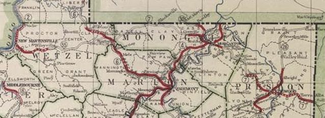
WV 7 original routing from WV 6 to Maryland
1923 Official
Adjustments: Between 1926-28, WV 7 was extended west with WV 6 to near Hundred, then replaced WV 55 to end at WV 2 New Martinsville.
WV 7 extended west to New Martinsville
1928 Official
Between 1934-37, WV 7 was removed from CR 7/32 Kane Creek (Preston County).
In 1938, WVDOH studied requesting replacing WV 7 from Morgantown to Maryland with an unspecified US route number. It is unclear if they formally requested this or not but it obviously did not happen.
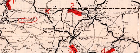
In the early 1950s, WV 7 was given its current routing that avoids Westover. The bridge across the Monongahelia River and into downtown Morgantown was mostly new construction. The old route via Westover became WV 7 ALT (now CR CR 19/25 Scotts Run Rd, WV 100 Dunkard Ave, and US 19 across the river).
It appears that by 1951, WV 7 was put on one-way splits in Morgantown with EB using Pleasant and Spruce while WB uses Walnut and Beechurst.
Between 1952-59, WV 7 was removed from CR 64 Deckers Creek Blvd-CR 857 Green Bag Rd-CR 7/41 Old Rte 7 in eastern Morgantown.
In 1960 (bridge date), WV 7 was extended north with WV 2 then west across a new bridge into Ohio.
Between 1963-72, WV 7 was straightened out east of WV 20 leaving behind a bit of WV 20, abandoned routing, and CR 7/23 Old Rte 7.
Improvements: By 1923, WV 7 was paved from about Cassville to Delislow; Monawn to Kingswood; Terra Alta to Maryland
In 1924, WV 7 was paved from Kingswood to Terra Alta.
In 1926 or 1927, WV 7 was paved from Delislow to Monawn
In 1928, WV 7 was paved from New Martinsville to WV 20; Hundred to Cottontown; Wadestown to Bula
In 1930, WV 7 was paved from Blacksville to Cassville
In 1932, WV 7 was paved from Knob Fork to Hundred; Cottontown to Wadesville; Bula to Blacksville (this made WV 7 paved continuously from Knob Fork to Maryland).
In 1938 or 1939, WV 7 was paved a couple miles east of WV 20
In 1940, WV 7 was paved from Wileyville to Knob Fork
About 1947, WV 7 was paved from near WV 20 to Wileyville, completing the pavement of WV 7.
WV 7 was multilaned on Monongahelia Blvd in 1977.
Comment: WV 7 is labeled as WV 7 SPUR on the Ohio River Bridge on some WV Officials for some reason.
|