ROUTE LOG
I-24 (exit 185), I-75 SB (exit 2): 0 - 0
TN 320: 2.2 - 2.2
TN 153: 0.7 -2.9
US 11 SB, US 64 WB, TN 2 SB, TN 317 WB: 3.3 - 6.2
TN 317 EB: 1.5 - 7.7
US 11 NB, US 64 EB, TN 2 NB: 2.6 - 10.3
Meigs-Hamilton Line: 4.0 - 14.3
I-75 NB (exit 20), TN 311 BEGIN: 4.9 - 19.2
US 11, US 64 Byp BEGIN, TN 2: 1.5 - 20.7
TN 60 SB, TN 311 EB: 3.3 - 24.0
TN 74: 0.3 - 24.3
US 64 WB, US 64 Byp END, TN 40 WB, TN 60 NB: 1.3 - 25.6
Polk-Bradley Line: 7.3 - 32.9
US 411, TN 35: 0.4 - 33.3
TN 314: 4.4 - 37.7
TN 30: 5.1 - 42.8
TN 68: 16.4 - 59.2
NC STATE LINE: 3.8 - 63.0
|
Creation: Tennessee first attempted to have US 74 extended west from Asheville NC in 1978. The proposed route was I-40 to TN 32 west to today's US 321 southwest to I-40 at TN 95, then following TN 95 and TN 61 north and east to end at US 25W Clinton. AASHTO rejected this proposal.
Adjustments: Tennessee appears to have tried again in spring 1981 (though the application has no route number suggested) that was the same as the 1978 extension except it would end at I-40 west at TN 95. AASHTO again turned this down, though nearly all of this routing was approved as an extension of US 321 in fall 1981 by AASHTO.
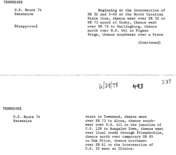
Tennessee tries to get US 74 extended in 1978
1978 spring AASTHO minutes
|
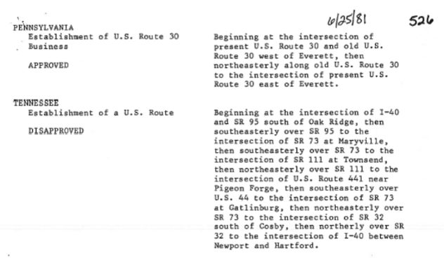
Tennessee tries it again in 1981
1981 spring AASTHO minutes
|
US 74 actually appeared in Tennessee in 1986 as an addition to US 64 from North Carolina to Cleveland; The Cleveland Bypass around the south of town to I-75; I-75 south to I-24 Chattanooga.

US 74 in the southeast corner of Tennessee
2001 Official
Posting: US 74 is not posted anywhere on I-75. Postings begin at the Cleveland Bypass leaving I-75.
Secret TN Route Overlay: TN 311 (Cleveland Byp, 4.8 mi)
TN 60 (Cleveland Byp, 1.6 mi)
TN 40 (Cleveland to NC, 37.4 mi)
Comment: US 74 only has one small non-duplexed segment, the 1.5 miles from I-75 Exit 20 to US 11-64 Cleveland.
East of I-75, US 74 is part of Appalachian Corridor K and is 4-lane improved from Cleveland to Ocoee and Ducktown to NC. The 25 miles in between follows the narrow path of the Ocoee River and upgrading this segment to modern 4-lane standards will be a tall and expensive task. Both the 2013 and 2019 versions of ADHS Corridor update documents say that the Ocoee River section is under location/environmental study.
Not sure of the point of extending US 74 to Chattanooga if it's not going to be signed that way.
|