ROUTE LOG
US 31W, US 41, TN 11: 0 - 0
I-65 (exit 97): 0.5 - 0.5
Sumner-Davidson Line: 0.4 - 0.9
TN 258: 6.0 - 6.9
TN 386 WB: 8.0 - 14.9
TN 109, TN 386 END: 0.5 - 15.4
TN 25 WB: 1.0 - 16.4
US 31E SB, TN 6 SB, TN 25 EB: 0.3 - 16.7
US 31E NB, TN 6 NB: 1.5 - 18.2
TN 52: 14.1 - 32.3
KY STATE LINE: 10.1 - 42.4
|
Creation: Appeared in 1982 or 1983 running generally as it does today.
Adjustments: In 1995 or 1996, TN 174 was rerouted in Gallatin to follow US 31E out to Albert Gallatin Ave then west back to Water Ave. The old route used Water Ave all the way from downtown.
Posting: posted as secondary routing everywhere
The overlay with TN 386 is fully posted; the TN 25 overlay is unposted and the US 31E overlay is posted at the north end only.
Secret US Route Overlay: None
Comment: The segment that turns north to Kentucky was once part of US 31E.
TN 174 throughout can be used as a backway alternative to US 31E.
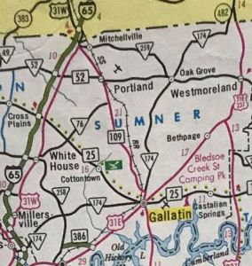
TN 174
1986 Official
|
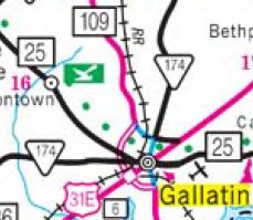
TN 174 rerouted in Gallatin
2004 Official
|
|