< TN 148 | Home | TN 150 >
| ||||||
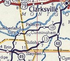
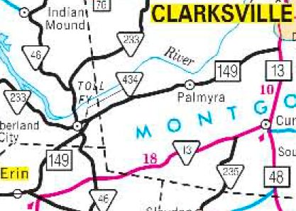
| ROUTE LOG TN 49: 0 - 0 Stewart-Houston Line: 4.0 - 4.0 TN 46 SB: 1.4 - 5.4 TN 46 NB: 0.2 - 5.6 TN 434: 0.7 - 6.3 Montgomery Stewart Line: 1.5 - 7.8 TN 13: 13.9 - 21.7 |
Creation: Appeared in 1953 or 1954 running generally as it does now.
Adjustments: In 1966, TN 149 was extended east from TN 13 (now River Rd) Hilltop to the new TN 13 alignment as new construction. In the early 1960s, TN 149 was given its causeway and bridge over Guice Creek near Cumberland City. The old alignment on the east side is still driveable. In 1979, TN 149 was placed on new alignment to west of Palmyra. Prior to this TN 149 used Fishermans Alley; Sheeks Cir; Killebrew Ln; Tarsus Church Rd; Hallibuton Cir; Harris Cir; a bit of Shiloh Canaan Rd; abandoned roadway In 1984, TN 149 was placed on new alignment from west of Palmyra to Hilltop. Prior to this TN 149 used Patsy Rd and the lengthy Palmyra Rd. In 1989, TN 149 was given its bypass of Cumberland City leaving behind "Old TN 149, a bit of TN 233 and all of TN 434. In 1992, TN 149 was rerouted onto new alignments north out of Erin, including the relocation of its endpoint with TN 49. The old TN 149 route used Cumberland City Hwy; Substation Loop; Pitt Loop Posting: Posted as primary routing throughout Secret US Route Overlay: None Comment: With all the improvements, TN 149 is a viable alternative to TN 13 from Erin to Clarksville.
| |||||