ROUTE LOG
TN 69 ALT: 0 - 0
Tennessee River Ferry: 10.6 - 10.6
TN 232: 2.6 - 13.2
TN 49: 10.0 - 23.2
|
Creation: Appeared in 1953 or 1954 running from the Tenneesee River west of McKinnon to TN 49 Tennessee Ridge.
Adjustments: In 2009, TN 147 was placed on the Benton-Houston Ferry across the river and extended west to TN 69A Big Sandy. A small stub of TN 147 to its former dead end at the river (which was posted) was removed from the highway system.
Posting: Posted as secondary routing throughout
Secret US Route Overlay: None
Comment: TN 147 uses the last state ferry on the Tennessee River still operating.
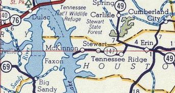
TN 147 originally east of the river only
1956 Gousha
|
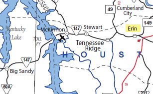
TN 147 extended to Big Sandy
2009 Official
|
|