ROUTE LOG
US 41, US 64, US 73, TN 2: 0 - 0
TN 156: 0.5 - 0.5
Hamilton-Marion Line: 5.5 - 6.0
GA STATE LINE: 0.6 - 6.6
|
Creation: Appeared in 1949 or 1950 running from essentially as it does today.
Adjustments: About 1961, 1.1 miles of TN 134 was put on new alignment to make way for I-24 from Running Water Creek bridge on I-24 WB to about Morgan Point Rd near Whiteside. TN 134's old alignment is occupied by I-24 EB in a couple spots.
In 1968, TN 134 was shifted slightly east in the area centered around TN 156 to accomodate the larger footprint of Running Water Creek caused by the creation of Nickajack Lake.
Posting: Posted as secondary routing throughout
Secret US Route Overlay: None
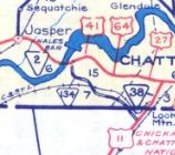
Comment: Parallels I-24 very closely its entire length.
|
TN 134
1951 Official
|