< TN 110 | Home | TN 112 >
|
|
|
| ROUTE LOG |
US 27, TN 29: 0 - 0 Sequatchie-Hamilton Line: 7.4 - 7.4 US 127, TN 8 SB, TN 28: 10.0 - 17.4 TN 399: 8.4 - 25.8 TN 8 NB: 4.1 - 29.9 Van Buren-Sequatchie Line: 1.0 - 30.9 TN 284: 5.9 - 36.8 TN 30: 8.2 - 45.0 TN 285 EB: 4.6 - 49.6 White-Van buren Line: 1.0 - 50.6 TN 285 WB: 0.9 - 51.5 US 70S WB, TN 1 WB: 3.1 - 54.6 TN 1 EB: 2.9 - 57.5 US 70, US 70S END, TN 26: 1.4 - 58.9 TN 289: 2.0 - 60.9 TN 135: 1.9 - 62.8 TN 136 SB: 4.6 - 67.4 Putnam-White Line: 1.8 - 68.2 TN 136 NB: 1.5 - 69.7 I-40 (exit 288): 2.6 - 72.3 US 70N, TN 24: 1.2 - 73.5 Overton-Putnam Line: 7.7 - 81.2 TN 293 EB: 3.15 - 84.35 TN 293 WB: 0.05 - 84.4 TN 84: 6.8 - 91.2 TN 85 WB: 0.6 - 91.8 TN 85 EB: 0.3 - 92.1 TN 52: 1.4 - 93.5 TN 294 SB: 1.6 - 95.1 TN 294 NB: 3.6 - 98.7 Pickett-Overton Line: 6.4 - 105.1 TN 325 WB: 5.9 - 111.0 TN 325 EB: 0.6 - 111.6 TN 295: 1.9 - 113.5 US 127, TN 28: 3.7 - 117.2
|
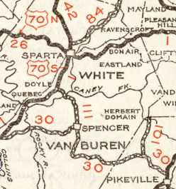
Creation: Appeared in 1929 or 1930 running from TN 30 Spencer to US 70S (now McMinnville Hwy) Doyle.
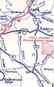
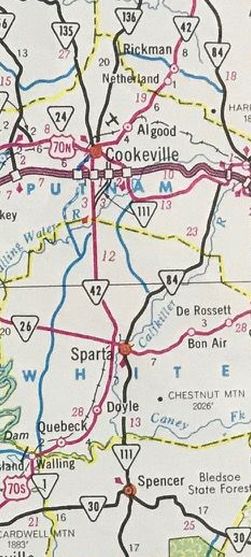
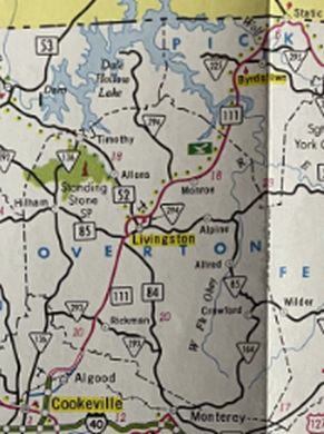
| Adjustments: Between 1957-60, TN 111 was extended south to TN 8. In 1966 (bridge date), TN 111 north was rerouted at Cummingsville to head north to end at US 70 Sparta. The old route from Cummingsville used Cornell St into Cummingsville; Hodges Ferry/Bridge Rd to Greenwood; TN 285; W. Gooseneck Rd into Doyle In 1969 (bridge date), the TN 111 bypass of Cookesville was in place from TN 42 (now TN 136) south of town northeast to US 70N. Maps up through at least 1973 continued to show TN 42 between Sparta and Cookesville, so it is unclear if TN 111 was signed on this or if it was two separate TN 111 pieces. In 1971 (bridge date), TN 111 was placed on its modern routing around to end at US 70S (now TN 1) outside Sparta. The old route into Sparta used Pleasant Hill Rd to Cummings and Hickory Valley Rd into Sparta. Also about 1971 (bridge date), TN 111 was given its bypass of central Spencer, leaving behind Andrew Parker Rd/Sparta St north of TN 30 and Old Dunlap Rd south of Spencer In 1975 (bridge date), TN 111 north southwest of Sparta was extended as new freeway to today's TN 289 north of Sparta, then replaced TN 42 to the south end of the Cookeville Bypass, connecting the two TN 111 pieces. In 1977 (bridge date), TN 111 north was extended as new construction to TN 42 (now E. 10th St) northeast of Cookeville. About 1979, TN 111 was placed on mostly new construction between TN 8 and Old Dunlap Rd. A moderate length Old State Route 111 was left behind at Pine Grove and a much longer one left behind down to the Sequatchie County line. In 1980 (bridge date), TN 111 north was extended as new construction around Algood to TN 42 (now E. Main St). It is unclear whether TN 42 was placed on this or whether TN 111 transitioned to TN 42 at the end of the bypass.
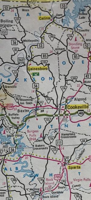
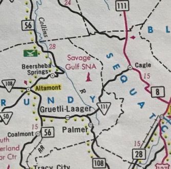
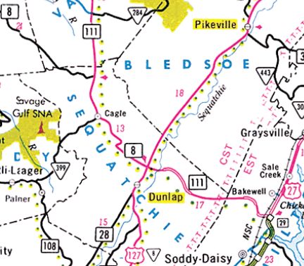
In 1983, TN 111 was extended south with TN 8 to Cagle, then west to TN 108 Palmer. In 1987, TN 111 from Palmer to Cagle was renumbered as TN 399. It is unclear if TN 111 south was rerouted to follow TN 8 to US 127 Dunlap, ended at The TN 8-399 jct or was truncated back to TN 8 near the Van Buren Line. About 1988, TN 111 was comverted to a full freeway from TN 289 north into Putnam County. This left behind parts of Burgess-Matthew Hwy, some of which is TN 135. Between 1990-93, TN 111 was extended north replacing the rest of TN 42 to US 127 at the Kentucky State Line. Note that maps did show TN 42 moved onto the new construction between Algood and Livingston first.
In 1995 or 1996, TN 111 south was definitely with TN 8 to Dunlap, then extended southeast to US 27 Soddy Daisy.
About 2004, TN 111 between US 127 and US 27 was converted into a full freeway. In 2013 or 2014, TN 111's north end was shifted west to meet the rerouted US 127, leaving behind a disconnected piece of old TN 111. On September 5, 2024, the Somerset-Pulaski County (KY) Economic Development Authority made public their idea to create a US 111 route from US 25 Mt. Vernon KY to Chattanooga. The Tennessee portion would take over the entirety of TN 111 and then follow US 27 down to Chattanooga. Credit to HB Elkins for discovering this. Supposedly Kentucky and Tennessee highway officials are considering requesting this corridor from AASHTO. But they did not do so at the fall 2024 AASHTO meeting. Posting: posted as primary routing throughout. Secret US Route Overlay: None Comment: TN 111 has become a major N-S corridor in east central Tennessee. TN 111 is part of Appalachian Development Highway System Corridor J from Soddy Daisy to Livingston. Most of TN 111 south of Livingston is multilane or freeway. | ||||||||||||