< TN 7 | Home | 8 Spur | TN 9 >
|
|
|
| ROUTE LOG |
GA STATE LINE: 0 - 0 I-75 (exit 1): 1.0 - 1.0 I-24 (exit 181): 4.7 - 5.7 US 11 SB, US 64 WB, TN 2 SB: 0.1 - 5.8 US 11 NB, US 64 EB, TN 2 NB: 0.5 - 6.3 TN 17 NB: 0.5 - 6.8 US 76 WB, TN 27: 1.9 - 8.7 US 41 SB, US 72 WB, TN 17 SB: 0.3 - 9.0 TN 316: 0.6 - 9.6 US 72 END, US 76, US 127 Begin, TN 27 SB: 0.1 - 9.7 TN 389: 0.5 - 10.2 US 27, TN 29: 2.9 - 13.1 TN 27 NB: 2.5 - 15.6 Sequatchie-Hamilton Line: 9.3 - 24.9 TN 283: 11.6- 36.5 TN 28 SB: 2.1 - 38.6 US 127 NB, TN 28 NB, TN 111 SB: 2.7 - 41.3 TN 399: 8.4 - 49.7 TN 111 NB: 4.1 - 53.8 Van Buren-Sequatchie Line: 3.3 - 57.1 Warren-Van Buren Line: 4.2 - 61.3 TN 127: 11.3 - 72.6 TN 56: 0.9 - 73.5
|
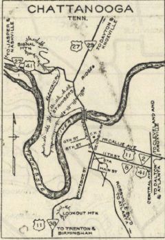
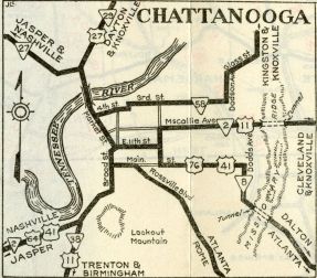
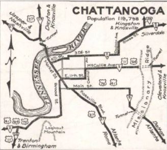
Creation: Appeared in 1923 as an original state highway, running from TN 2 (11th at Market) Chattanooga southeast to Georgia near Ringgold GA
| Adjustments: In 1929, TN 8 was removed from Old Ringgold Rd and instead used the new Bachman Tunnel to Dodds Ave to Main St to Central Ave In 1931 or 1932, TN 8 was truncated in Chattanooga to end at 11th at Central. 11th St became part of TN 2. In 1935 or 1936, TN 8 was removed from Central Ave and instead used Main to end at US 27 Rossville Blvd.
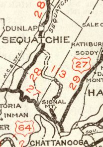
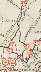
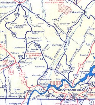
In 1939 or 1940, TN 8 was extended through Chattanooga with US 27 and TN 27, then replaced TN 113 through Signal Mountain to end at TN 28 (now TN 283) southeast of Dunlap. In 1951, TN 8 was extended north with TN 28 to Dunlap, then northwest as new state highway to TN 56 McMinnville.
Between 1957-60, TN 8 was changed to follow Main St to Broad north to 4th St east to Market in downtown Chattanooga. In 1963, TN 8 was removed from Old State Hwy 8 leaving US 127 in northern Dunlap. Also around this time TN 8 was rebuilt on its Cumberland Plateau ascension leaving a lengthy abandoned alignment to the west. Also in 1963, TN 8 was removed from Stone Man Rd/Old Hwy 8 (no longer crosses river)/McGee Rd and also Old Harrison Ferry Rd southeast of McMinnville. Sometime between 1982-97, TN 8 was largely rebuilt between TN 111 and Stone Man Rd near McMinnville. Surviving pieces of the old route: Sequatchie County: SVC Rd/Indian Dr; Van Buren County: part of Isha Ln; Warren County: Ford Dr; Mountain Top LN; Scott's Branch Rd; Grady's Rd; Rocky Top Rd Posting: TN 8 is fully unposted south of the US 127/TN 111 interchange, except for 2 shields in Chattanooga. One of those is on I-24 and the shield should be a TN 27 shield. The other is a trailblazer on Broad at 4th, which although correct is completely useless given the several other unsigned turns TN 8 utilizes in Chattanooga. Secret US Route Overlay: US 41 (9.0 mi) US 72 (0.7 mi) US 127 (29.6 mi) Comment: TN 8 provides a good route to reach Chattanooga from the Dunlap and McMinnville areas. | |||||||||||
Previous: TN 7 |
Next: 8 Spur | TN 9
Top | Tennessee Hwy Index
Home
Page last modified 11 July 2021