< SC 692 | Home | SC 702 >
|
|
|
| ROUTE LOG |
US 17: 0 - 0 SC 171 NB: 0.3 - 0.3 SC 171 SB: 1.2 - 1.5 END SC 700: 19.3 - 20.8
|
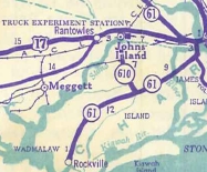
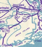
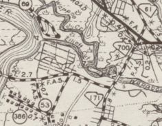
Creation: SC 700 appeared in 1940 as a renumbering of part of SC 61.
|
Adjustments: Between 1941-52, SC 700 was removed from Wappoo Dr/Plymouth Ave on James Island. In 1956 (bridge date), SC 700 was placed on the current Wappoo Cut bridge, leaving behind Country Club Dr and the Wappoo Cut Public Boat Landing.
In 2004, SC 700 was put on a new bridge over the Stono River, leaving behind S-10-2535 which is now a frontage road to access a neighborhood cutoff by the new long continuous bridge over the marsh. Improvements: Paved upon inception; multilane from US 17 to the SC 171 south split in 1956. Between 1977-79, SC 700 was multilaned from SC 171 west to the start of the Stono River causeway. In 2004, SC 700 was multilaned across the Stono River and its marshes. Comment: SC 700 passes through some oak canopy sections on Johns Island. SC 700 may not be posted anywhere on its western half or so. SC 700 is one of the main ways to get from the Charleston area to Kiawah and Seabrook Islands. Lou Corsaro points out that SC 700 is one of those routes in the Lowcountry where no one refers to it by its number. To the locals, it is just Maybank Hwy. From my own experience about the only state primary route in the Charleston area that is called its number is SC 61. | |||||||||
Previous: SC 692 |
Next: SC 702
Top | South Carolina Hwy Index
Home
Page last modified 24 April 2015