< SC 60 | Home | SC 61 ALT | SC 62 >
|
|
|
| ROUTE LOG |
US 78: 0 - 0 US 21: 6.6 - 6.6 Colleton-Bamberg Line: 0 - 6.6 SC 217: 7.1 - 13.7 I-95 (exit 68): 3.6 - 17.3 US 15: 2.8 - 20.1 SC 651: 7.1 - 27.2 Dorchester-Colleton Line: 6.8 - 34 SC 27: 3.5 - 37.5 US 17 ALT SB: 5.0 - 42.5 US 17 ALT NB: 0.3 - 42.8 SC 165: 4.6 - 47.4 Charleston-Dorchester Line: 5.5 - 52.9 SC 461: 9.5 - 62.4 SC 7: 0.5 - 62.9 SC 171 NB: 1.5 - 64.4 SC 171 SB: 1.6 - 66 US 17: 0.3 - 66.3 SC 30: 1.0 - 67.3
|
Creation: SC 61 appeared in 1923 as new primary routing, running from SC 6 (now US 17) west of Charleston to SC 2 (now S-18-65 Richardson Ave) Summerville. This is the only SC 61.
| Adjustments: In 1930, SC 61 may have been truncated to the new SC 64, ending at today's Bacons Bridge Rd and Main St. In 1934 or 1935, SC 61 was extended north to US 78/SC 2 northwest of Summerville along Richardson Ave, which had at one time been the original routing of SC 2.
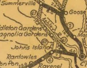
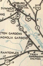
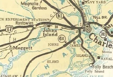
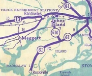
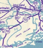
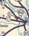
In Feb 1938 (SCDOT), SC 61 was extended east with US 17 for a mile, then south as new primary routing over Wappoo Cut, then west as more new primary routing to end at today's S-10-54 Main Rd on Johns Island. In 1939, SC 61 was exended southwest as more new primary routing to end at Rockville. By 1940, SC 61 was removed from Stallsville Loop south of Summerville leaving behind SC 61 ALT (now S-18-9 and S-18-199 Trolley Rd). In 1940, SC 61 south was truncated back to its original ending on US 17, leaving behind a bit of US 17 and all of SC 700 (note that SC 61 used Country Club Dr and the Wappoo Cut Public Boat Landing; Wappoo Dr/Plymouth Ave on James Island; S-10-2535 paralleling the new Maybank Hwy bridge over the Stono River). In 1948, SC 61 was rerouted to use S-10-26 Wappoo Rd (had been SC 61 ALT) to reach US 17, leaving behind SC 614 along Ashley River Rd and S-10-6 on Magnolia Dr. In 1951, SC 61 was removed from Wappoo Rd (became S-10-26 again) and replaced all of SC 614 to end at US 17 at the Ashley River Bridge.
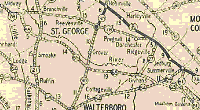
In 1952, SC 61 was rerouted at Cooks Crossroads to instead replace SC 650 and SC 65 all the way out to US 78 in Bamberg County. The old route through Summerville became SC 165 CONN and SC 165 (some of this is now S-18-64, US 17 ALT, S-18-65).
In 1997, SC 61 was extended south from US 17 to SC 30 as new construction. Improvements: Fully paved in all alignments since about 1928. SC 61 was multilaned from SC 171 NB split to US 17 in 1962. The first official map to show SC 61 4-laned from SC 171 to SC 7 was between 1986-88, but I know it was 4-laned by the late 70s. SC 61 was 4-laned from SC 7 north to the SC 61 CONN to the Mark Clark Expwy (now SC 461) about 1987. SC 61 was 4-laned when built between US 17 and SC 30 in 1997. Comment: SC 61 serves as an alternate to US 78, with fewer towns. In advance of the US 78-SC 61 split there is a mileage sign to Charleston for both routes. From SC 7 to SC 165, SC 61 is a state scenic route, as it passes by historic plantations (Magnolia, Middleton, Drayton Hall). The road has a canopy of live oaks over this stretch. However, Hurricane Hugo and some development on the southern end of this has lessened its beauty over the years. SC 61 is technically blown off by I-526, but a 4-lane connector was built in the mid 1980s to connect them. This connector was part of the "SC 61 Expressway" which extends out to Bees Ferry Road and was intended to eventually connect back up with SC 61 somewhere further north. In the meantime it has become SC 461. | ||||||||||||||


Previous: SC 60 |
Next: SC 61 ALT | SC 62
Top | South Carolina Hwy Index
Home
Page last modified 21 November 2015