< 650 to 659 | Home | 700 to 709 >
| SC 660 not currently assigned | |||||||||||||
| Previous SC 660's: |
SC 660: Appeared in 1941 or 1942 as new primary routing. Ran from SC 279 (current S-31-28) to SC 154 near McCutchans Crossroads in Lee County.
In 1948, the 3 miles of SC 660 were downgraded to S-31-33. | 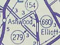 |
|||||||||||
| SC 662 not currently assigned | |||||||||||||
| Previous SC 662's: |
SC 662: Appeared in 1941 or 1942 as new routing. Ran from SC 82 (current SC 81) Willington east to SC 617 (current S-35-37) in northern McCormick County.
The 4 miles of SC 662 were downgraded to S-35-39 in 1948. | 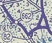 |
|||||||||||
| SC 663 not currently assigned | |||||||||||||
| Previous SC 663's: |
SC 663: Appeared in 1941 or 1942 as new primary routing. Ran from US 501 Spring Branch north 4 miles to SC 571 (current S-33-27) in northern Marion County.
SC 663 was downgraded to S-33-23 in 1948. |  |
|||||||||||
| SC 664 not currently assigned | |||||||||||||
| Previous SC 664's: |
SC 664: Appeared in 1941 or 1942 as new primary routing. Ran as a cutoff between SC 177 (current US 176) and US 176 (current US 176 jct with S-36-36) in northern Newberry County.
The 3 miles of SC 664 were renumbered as part of SC 177 in 1948. Today, none of this is even a secondary route. It is an unpaved road east of Baker's Crossroads with the bridge over Indian Creek gone. | 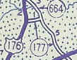 |
|||||||||||
| SC 665 not currently assigned | |||||||||||||
| Previous SC 665's: |
SC 665: Appeared in 1941 or 1942 as new primary routing. Ran as 1 mile cutoff between SC 5 (current US 21) and SC 555 north of Columbia.
In 1948, SC 665 was downgraded to S-40-34, which now runs through the SC Dept of Mental Health Corrections Facilities. |  |
|||||||||||
| SC 667 not currently assigned | |||||||||||||
| Previous SC 667's: |
SC 667: Appeared in 1941 or 1942 as new primary routing. Ran from SC 261 (current SC 375) Greeleyville north 4 miles just past Bennett Swamp.
In 1948, SC 667 was downgraded to S-45-27 and S-45-35. | 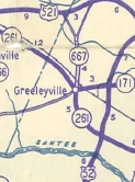 |
|||||||||||
| SC 668 not currently assigned | |||||||||||||
| Previous SC 668's: |
SC 668: Appeared in 1941 or 1942 as a renumbering of SC 6, which was relocated to avoid drowning in Lake Moultrie. It ran from SC 6 near Moncks Corner northwest to Pinopolis.
In 1948, SC 668 was downgraded to S-8-5. |  |
|||||||||||
| SC 670 not currently assigned | |||||||||||||
| Previous SC 670's: |
SC 670: Appeared in 1941 or 1942 as new primary routing. Ran from SC 10 Bradley to US 25-178 south of Greenwood. The 1942 Official Map implies there was a brief break near Bradley.
In 1951 or 1952, SC 670 was extended south to McCormick using a multiplex with SC 10, then upgrading a secondary road (which had once been SC 104). This gave SC 670 its longest length at 22 miles. In 1954, SC 670 was truncated back to its Bradley to Greenwood route, as US 221 was extended south of Greenwood (along today's SC 10 though). SC 670 was killed between 1968-70 when US 221 was rerouted over its pavement. | 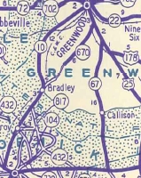 |
|||||||||||
| SC 691 not currently assigned | |||||||||||||
| Previous SC 691's: |
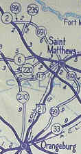
SC 691: Appeared in 1937 or 1938 as new primary routing. Ran from SC 69 (current SC 33) Orangeburg northeast 6 miles to the Calhoun County Line.
In 1940, SC 691 was extended to loop around to St. Matthews, then continue northwest to end at US 21-SC 2 (current US 176). This made SC 691 into a 22 mile route. In 1948, SC 691 was downgraded to S-38-29, S-9-45, S-9-20, a little piece of SC 6, S-9-21 and S-9-24 | 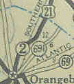
 |
|||||||||||
|
|
|
| ROUTE LOG |
US 321: 0 - 0 Orangeburg-Lexington Line: 3.7 - 3.7 SC 172: 5 - 8.7
|
Creation: Appeared in 1949 as a resurrected state route. Ran as it does today. | Adjustments: SC 692 first appeared in 1941 or 1942 as new primary routing, beginning in Swansea and heading south to end at the Orangeburg County Line. Improvements: Fully paved when resurrected in 1949. Comment: SC 692 ends just short of US 178. 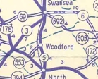 |
||||||
Last Update: 3 March 2005
Previous: SC 650 - 659 |
Next: SC 700 - 709
Top | South Carolina Hwy Index
Home