< 660 to 699 | Home | 710 to 719 >
|
|
|
| ROUTE LOG |
US 17: 0 - 0 SC 171 NB: 0.3 - 0.3 SC 171 SB: 1.2 - 1.5 END SC 700: 19.3 - 20.8
|
Creation: Created in 1940. Had the same endpoints as today, which was a renumbering of part of SC 61.
| Adjustments: SC 700 was rerouted slightly when the Wappoo Cut Bridge was built in 1958. Until then, SC 700 made no turns during its multiplex with SC 171 (or SC 615 before it). Comment: SC 700 is one of the main ways to get from the Charleston area to Kiawah and Seabrook Islands. Lou Corsaro points out that SC 700 is one of those routes in the Lowcountry where no one refers to it by its number. To the locals, it is just Maybank Hwy. From my own experience about the only state primary route in the Charleston area that is called its number is SC 61. 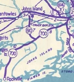
|
||||||||
| U.S. 701 |
| SC 701 not currently assigned | |||||||||||||||
|
|
|
| ROUTE LOG |
SC 246: 0 - 0 SC 72: 7.2 - 7.2 Saluda-Greenwood Line: 5.2 - 12.4 SC 39: 6.7 - 19.1
|
Creation: Appeared in 1951 or 1952 as a resurrected state route. Ran as it does today. | Adjustments: SC 702 originally appeared in 1940 as a loop off SC 7 (current S-1-3 and S-24-1) west of Greenwood. In 1941 or 1942, SC 702 was extended east through Greenwood to SC 246 Saluca, then east to SC 39 near Greenwood State Park. This gave SC 702 its longest length at 21 miles. 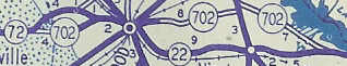
In 1948, SC 702 was reduced back to its original routing west of Greenwood. East of Greenwood became S-25-29, S-25-101, and S-25-179. It is unclear what SC 246 to SC 39 became, but is once again SC 702. SC 702 became today's SC 72 in 1950. Improvements: Fully paved when resurrected. Comment: SC 702 is a good short cut to use between Saluda and either US 25 or US 178 on the other side of Greenwood. |
||||||||
|
|
|
| ROUTE LOG |
US 17: 0 - 0 I-526 BUS SPUR: 2.6 - 2.6 SC 517: 6.3 - 8.9 END SC 703: 2 - 10.9
|
Creation: Appeared in 1933 as a renumbering of the first SC 401. SC 703 was originally a spur off US 701 from Mt. Pleasant to Sullivans Island and the Isle of Palms. Shown as 7 miles long.
| Adjustments: By 1938, SC 703 had become 8 miles long, probably due to the relocating of US 17-701 in Mt. Pleasant to Coleman Blvd. In 1945, SC 703 was rerouted to use the Ben Sawyer Bridge. SC 703 had previously used the Pitt Street Bridge which connected to the west end of Sullivan's Island. It is unclear if SC 703 used Pitt St all the way from the bridge to US 17-701, or if it used some of today's S-10-100. In the late 70's or early 80's, SC 703 was truncated to 41st Ave. Before Wild Dunes was built, SC 703 ran down Jasper until its dead end. In 1992, SC 703 south was extended along Coleman Blvd. to meet US 17 at the Cooper River Bridge, replacing the southern half of US 17 Business. Improvements: Fully paved upon creation. Multilaned from Coleman Blvd. south to the causeway by 1975; Multilane along its Coleman Blvd. section, as well. Comment: SC 703's Ben Sawyer Bridge is the drawbridge that was toppled onto its head by Hurricane Hugo in 1989, but was placed back on its deck and is still in use today. This incident is partly what led to the building of the Isle of Palms Connector, SC 517. 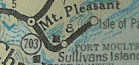 |
||||||||
| SC 704 not currently assigned | |||||||||||||||
| Previous SC 704's: |
SC 704: Appeared in 1939 as new primary routing. Ran from US 21 (current US 321 Bus) Chester south 4 miles, past Chester State Park.

In 1940, SC 704 was extended south all the way to SC 215 near Salem Crossroads in Fairfield County, a total length of 23 miles. In 1948, SC 704 was downgraded to S-12-16, S-12-22, and S-20-18 | 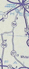 |
|||||||||||||
| SC 705 not currently assigned | |||||||||||||||
| Previous SC 705's: |
SC 705: Appeared in 1940 as new routing. Ran as a 4 mile spur south off SC 7 (current SC 72) in eastern Laurens County, ending at what is now SC 66.
In 1948, SC 705 was downgraded to S-30-26. |  |
|||||||||||||
| SC 706 not currently assigned | |||||||||||||||
| Previous SC 706's: |
SC 706: Appeared in 1940 as new routing. Ran from SC 7 (current SC 72) Whitmire to US 76-SC 2 Jalapa, 13 miles away.
In 1948, the northenmost 3 miles of SC 706 was renumbered as part of SC 66. The rest became S-36-32. | 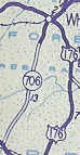 |
|||||||||||||
|
|
|
| ROUTE LOG |
US 17 Bus: 0 - 0 US 17: 0.4 - 0.4 Horry-Georgetown Line: 0.4 - 0.8 SC 544: 9.5 - 10.3 US 17: 2.3 - 12.6
|
Creation: Appeared in 1949 as a renumbering of part of US 501. Originally ran from SC 544 Socastee east to US 501 in Myrtle Beach. This is the 2nd SC 707.
| Adjustments: Between 1959-64, SC 707 was rerouted to meet US 501 further north, using Socastee Hwy. This left behind S-26-15 Old Conway Hwy. This change was made to make room for the current Myrtle Beach Airport. About 1982, SC 707 west was extended over what was SC 544 down to Murrells Inlet. Additionally, SC 707 east was truncated to its current ending. The part east of US 17 became Old Socastee Hwy. This brought SC 707 to its greatest length. Improvements: Fully paved at creation. No multilane sections. Comment: SC 707 is not very exciting, although it was once the only way to get to Myrtle Beach as the original SC 38. | Previous SC 707's: |
SC 707 #1: Appeared in 1939 as new primary routing. Ran from US 701 Yauhannah west to SC 51 (current SC 261-513 jct)
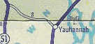
In 1940, SC 707 was extended north and west from SC 51 in a loop to end at SC 51 (current SC 261) Oatland. SC 707 was 16 miles long. 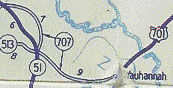 |
||||||
Last Update: 7 January 2005
Previous: SC 660 - 699 |
Next: SC 710 - 719
Top | South Carolina Hwy Index
Home