< SC 460 | Home SC 462 >
|
|
|
| ROUTE LOG |
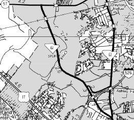
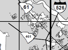
SC 61: 0 - 0 I-526 (exit 11): 0.7 - 0.7 END SC 461: 3.0 - 3.7
|
Creation: SC 461 appeared in 2011 (GMSV) as a renumbering of SC 61 SPUR, running the way it does now. This is the 2nd SC 461.
| Adjustments: None Improvements: Fully paved and multilaned upon designation. Comment: SC 461 may only be posted at the I-526 interchange. There are long range plans to continue SC 461 back to SC 61 north of the plantations.
| Previous SC 461's:
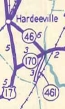
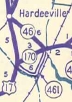
1946 ROUTE LOG US 17, SC 170: 0 - 0 SC 170: 5.5 - 5.5 SC 46: 0.1 - 5.6 |
SC 461 #1: Appeared in 1940 as new primary routing, running from SC 46 south to Levy Station.
In 1942, SC 461 was extended west from Levy Station to US 17/SC 170 Limehouse. In 1947, SC 461 was downgraded to S-7-22 north of Levy Station (today this is now in Jasper County and is part of SC 315 today) and S-27-21 (now part of S-27-34).
|
||||||||||
Previous: SC 460 |
Next: SC 462
Top | South Carolina Hwy Index
Home
Page last modified 17 May 2015