 |
From:  Tega Cay (York County) Tega Cay (York County)
To:  south of Fort Mill (York County) south of Fort Mill (York County)
Total Length: 12.4 miles
|
|
|
|
|
ROUTE LOG
SC 160: 0 - 0
I-77 (exit 88): 2.2 - 2.2
US 21: 1.1 - 3.3
US 21 Bus NB: 0.3 - 3.6
US 21 Bus SB: 0.7 - 4.3
SC 160: 3.2 - 7.5
US 21 Bus: 4.9 - 12.4
|
|
Creation: SC 460 appeared in 2012 as an upgrade to S-46-98; overlay with US 21 Bus; upgrade to S-46-270; newly constructed segments in between some of these designations, which were completed by 2008 and the entirety of SC 460 was first posted as SC 160 TRUCK. This is the 2nd SC 460.
Adjustments: In Jan 2020 (SCDOT), SC 460 was extended south and west back to US 21 Business south of Fort Mill. Everything east of Banks St was new construction. The piece west of Banks St was S-46-1719.
Improvements: Fully paved upon designation; multilaned upon designation from just east of I-77 west to SC 160.
Comment: Forms a 3/4 loop around the north, east, and south of Fort Mill. No idea why the northern part of this wasn't made SC 160 Bypass.
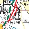
SC 460 around north of Fort Mill
2012 Official
|
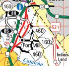
SC 460 extended to south of Fort Mill
2022 Official
|
|
| Previous SC 460's:
1946 ROUTE LOG
SC 462: 0 - 0
END SC 460: 3.9 - 3.9
|
|
SC 460 #1: Appeared in 1943 as new primary routing, running from SC 462 (nnow US 278/SC 46 jct) east to the ferry landing for Hilton Head Island.
In 1947, SC 460 was downgraded to S-7-39. Today it is US 278 and S-7-242 to the old ferry landing.
| 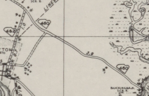
SC 460 in southeastern Beaufort County
1943 Beaufort County
|