< SC 56 | Home | SC 58 >
|
|
|
| ROUTE LOG |
SC 41, SC 41 ALT: 0 - 0 SC 9 EB: 10.8 - 10.8 US 301 SB, US 501 SB, SC 34: 1.0 - 11.8 US 301 NB, US 501 NB: 1.0 - 12.8 I-95 (exit 193): 1.1 - 13.9 SC 9 WB: 3.3 - 17.2 NC STATE LINE: 9.3 - 26.5
|
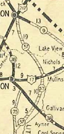
Creation: SC 57 appeared about 1929 as new primary routing, running from SC 175 (now SC 41 ALT) Centenary north to Mullins then northwest to end at SC 9 Dillon. This is the only SC 57.
| Adjustments: In 1952, SC 57 south was truncated to Fork, with the road to Centenary becoming SC 41.
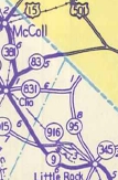
Also in 1952, SC 57 was extended with SC 9 through Dillon to Little Rock, then replaced SC 95 to North Carolina.
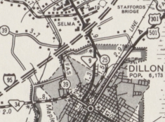
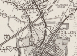
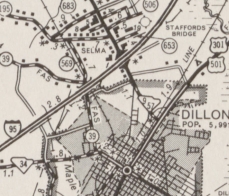
Between 1974-76, SC 57 was rerouted in Dillon to use US 301-501 and Radford Blvd. County maps show that SC 9 moved to this alignment a few years prior. The old route became a bit of SC 34 plus S-17-96 Martin Luther King Jr Blvd.
Improvements: The first piece of SC 57 to be paved was from US 501 to Mullins, in 1933. In 1937, SC 57 was paved from Floyd Dale to Dillon. The remainder of SC 57 was paved in 1938. SC 57 is multilane from Dillon to I-95, by 1974. Comment: SC 57 is the only current SC Primary route remaining that becomes a secondary route at the North Carolina border. | ||||||||||||


Previous: SC 56 |
Next: SC 58
Top | South Carolina Hwy Index
Home
Page last modified 26 December 2015