< SC 52 | Home | SC 53 ALT | SC 54 >
|
|
|
| ROUTE LOG |
US 378: 0 - 0 SC 58 NB: 6.0 - 6.0 I-95 (exit 141): 0.3 - 6.3 SC 58 SB: 0.1 - 6.4 SC 341: 5.3 - 11.7 SC 403: 0.4 - 12.1
|
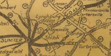
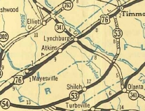
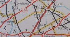
Creation: SC 53 appeared about 1926 as new primary routing, running from SC 341 below Hobbs Crossroads north to SC 3 (now US 76) Timmonsville. This is the only SC 53.
| Adjustments: In 1936, SC 53 was extended southwest as new primary routing by Act of SC Legislature to end at SC 54 (now US 378).
In 1968, SC 53 was completely decommissioned: north of Hobbs Crossroads became SC 403 and south of Hobbs Crossroads became S-43-10. In 1970, SC 58 was restored to run from US 378 to SC 403 Hobbs Crossroads.
Improvements: SC 53 was paved in Sumter County in 1937. SC 53 bcame fully paved in 1941. SC 53 has no multilane segments. Comment: SC 53 does not really serve any useful purpose. SC 53 is the only route to be decommissioned and resurrected not in association with the great 1947 denumbering. When the I-95 overpass was undergoing maintenance in the early 90's, they uncovered the initial painted identification of the route - S-43-10, meaning the downgrade was real. Of course, the bridge still carried SC 58... | |||||||||

Previous: SC 52 |
Next: SC 53 ALT | SC 54
Top | South Carolina Hwy Index
Home
Page last modified 1 January 2016