< VA 164 | Home | VA 165 | VA 166 >
| ||||||||||||
| ROUTE LOG VA 165: 0 - 0 END VA 165Y: 0.29 - 0.29 |
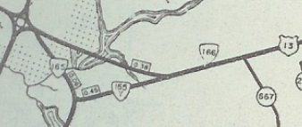
Creation: VA 165Y was created Oct 1950 (CTB) as a renumbering of US 13, running as a cutoff between VA 165 Kempsville Rd and US 13 Northampton Blvd.
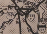
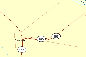
Adjustments: Around 1964, I-64 was under construction at the Northampton Blvd interchange, which is where VA 165-Y ended. Thus VA 165-Y was truncated to the west side of the interstate, shortening the route by 0.16 miles, and no longer connecting to Northampton Blvd. Satellite views also suggest the water plant has shortened the road a little bit more. Improvements: Paved upon inception; no multilane segments Posted: Has not been posted back to at least 1991, and likely hasn't been posted since the early 1960s. Multiplexes: None Legislative names: NONE Other names: Waterworks Rd Scenic Byway: No segments Comment: There are only two references to VA 165-Y in the CTB, the last in 1959 where it is still referred to as Waterworks Rd. Oddly, the VDOT On-line transportation map from the early 2010s clearly showed VA 165-Y using adjacent Taylor Dr over to the High School, creating some erroneous confusion about what road this used. No matter where VA 165-Y is though, it is sure pointless to be anywhere at all.
Previous: VA 164 |
Next: VA 165 | VA 166
Page last modified 23 December 2017 | |||||||||||