US 33/VA 33 depicted in 1975-81 Officials
1975 Official
VA 33 only depicted on 1982 Official downtown inset
1975 Official
Maps no longer show route 33 anywhere near central Richmond
1988 Official
US 33/VA 33 Transition
Official State Maps
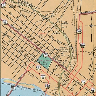
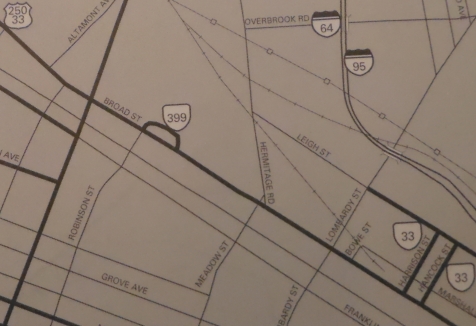
Beginning with the 1975 issue, a downtown inset of richmond was included. A US 33-250 shield is shown on Broad between 9th St and I-95, while a VA 33 shield is shown on Broad between US 360 (18th) and US 60 (21st). This is shown on every issue through 1981.
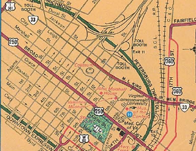
On only the 1982 Official, the new Martin Luther King Jr bridge is open and VA 33 is shown on Leigh just east of US 1-301. There is no US 33 shield on the downtown inset (west edge is US 1-301/VA 33 jct). On the main Richmond inset the easternmost US 33-250 shield is between Lombardy and US 1-301.
On the 1984 and 1986 Officials, US 33-250 is labeled only between Staples Mill and VA 161. The downtown inset is unchanged except US 250 is now labeled on Broad between US 360 (18th) and US 60 (21st).
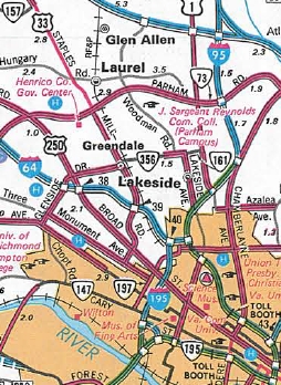
Beginning with the 1988 Official and continuing with every issue since, there are no US 33-250 combo shields on Broad and the only US 33 shield is just east of VA 157.
|
US 33/VA 33 depicted in 1975-81 Officials 1975 Official |
VA 33 only depicted on 1982 Official downtown inset 1975 Official |
Maps no longer show route 33 anywhere near central Richmond 1988 Official |
VDOT County Maps:
The 1995 and 2004 Henrico County maps show VA 33 on Hancock/Harrison and the first US 33 shield is on Broad just west of VA 161.
 US 33-250 on Broad St near I-95. 1975 Henrico County |
 VA 33 on Harrison/Hancock 1995 VDOT City Atlas |
VDOT Route Logs:
By 1979, US 33 and VA 33 are both defined to end at US 360 (Broad and 17th). Oddly, US 250's endpoint is described as Broad at 23rd (US 60).
The 1999 route log (next one up I have), shows both US 33 and VA 33 as ending at Broad and Harrison.
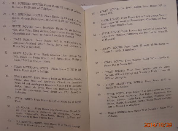 US 33 and VA 33 specifically defined to meet at US 360 1979 Route Log |
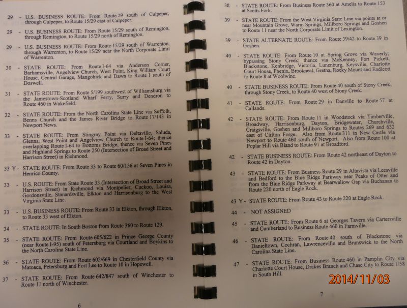 US 33 and VA 33 specifically defined to meet at Broad and Harrison 1999 Route Log |
AASHTO Log: The approval document from 1981 says Virginia was moving US 33 from Leigh at Hancock/Harrison to the ML King Bridge.
The 1989 AASHTO log specifically defines the transition as being on the Martin Luther King Jr Bridge. (page 7 of this document but Virginia's actual application described the new endpoint clearly as Broad at Hancock/Harrison.
The now-removed AASHTO online database which includes US routes created after 1989 also had the US 33/VA 33 transition on the Martin Luther King Jr Bridge.
However, AASHTO got it WRONG. This is what Virginia's application from Sept 9, 1981 requested:
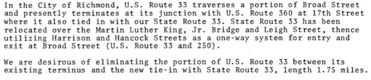
CTB documents:
In Sept 1981, the CTB moved VA 33 to the Martin Luther King Jr bridge, Leigh Ave, and Hancock/Harrison splits.
In Dec 1981, the CTB explicitly said the US 33-VA 33 transition point had been Broad and 17th (US 360).
Postings in the field:
Pictures in the field seem to suggest that the transition point IS on the Martin Luther King Jr bridge. I am aware of only 2 VA 33 shields up as of summer 2014 west of the bridge. Eastbound there is just one US 33 shield east of the bridge, although there are a few westbound US 33 shields east of the bridge.
|
Aug 2014 GMSV of I-95 SB ramp to US 1-301 and VA 33. |
July 2014 GMSV of EB Leigh St approaching Adams St. |
|
July 2011 GMSV of US 1-301 SB at VA 33. This assembly has been removed. |
July 2011 GMSV of US 1-301 NB at VA 33. This assembly has been removed. |
|
Oct 2007 GMSV of WB Leigh St at US 1-301. Not long after, the sign was moved across the US 1-301 NB lanes and replaced with a US 33 shield. |
July 2014 GMSV of WB Leigh at US 1-301, now with a US 33 shield. |
|
Aug 2014 GMSV on WB Leigh at 8th |
Aug 2014 GMSV on EB Leigh at 10th |
|
July 2014 GMSV westbound on the Martin Luther King Jr Bridge near its eastern end. |
July 2014 GMSV eastbound on the Martin Luther King Jr Bridge near its eastern end. |
|
Aug 2014 GMSV westbound on Mosby St approaching the turn to the Martin Luther King Jr Bridge. |
Aug 2014 GMSV of EB Mosby St approaching Fairmount Ave. This is the first VA 33 EAST posting since Leigh at Adams |
|
Aug 2014 GMSV westbound 33 on Fairmount approaching Mosby St. |
Aug 2014 GMSV westbound 33 on Fairmount leaving Nine Mile Rd |
|
Aug 2014 GMSV eastbound 33 on Fairmount zig-zagging to Nine Mile Rd. This is the last US 33 east shield in Richmond and on the left you can see a correct VA 33 shield. |
Aug 2014 GMSV westbound 33 on Nine Mile Rd zig-zagging to Fairmount. As far as I know this is the westernmost VA 33 WEST marker on VA 33 itself within Richmond. |
|
Aug 2014 GMSV westbound 33 on Nine Mile Rd at 30th St. |
Aug 2014 GMSV eastbound 33 on Nine Mile Rd at 31st St. |
![]()
![]()
Page last modified 24 March 2022
(C) 2022-2008 Mike Roberson, Adam Froehlig