| Formerly: |
|
NC 345-E: Implied to have been born between 1931-1936. It is shown but not labeled on the 1936-1949 Dare County Maps.
It ran from NC 345 (current US 64 Business) into central Manteo. The 1957 Dare County Map explicitly labels NC 345-E.
The 1962 Dare County Map does not show a secondary number nor a primary number, but the 1968 Dare County Map shows NC 345-E downgraded to SR 1150 which today is Burleigh St.
NC 345-E ran one street below NC 400 WB.
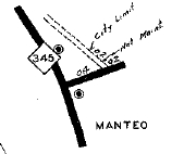
NC 345-E implied
|
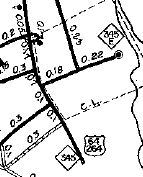
NC 345-E explicitly shown
|
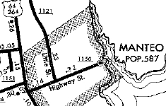
NC 345-E downgraded to SR 1150
|
|