


|
|
|
|
|
Virginia State Route Error Shields
This page highlights errors involving Virginia's State Highways
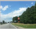
Last update: 10/30/16 - errors involving VA 3, VA 13, VA 20 Bus, VA 28, VA 33, VA 36, VA 89, VA 141, VA 166, VA 170, VA 226, VA 337
|
|
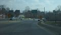
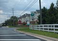
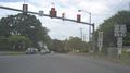
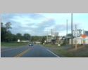
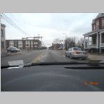
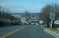
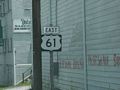
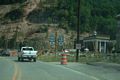
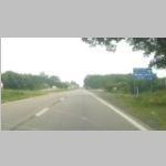
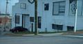
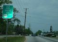
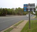
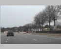
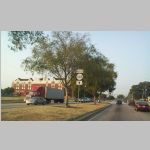
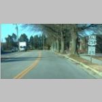
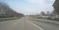
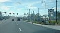
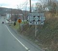
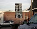
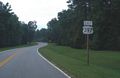
This is at the western end of the Fredericksburg bypass. VA 3 East does not turn left with VA 3 Business. This was corrected in 2013. Taken by Mapmikey, 3/11/09. | ||
|
|
|||
|
|
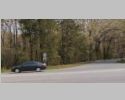
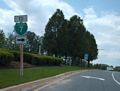
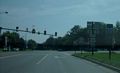
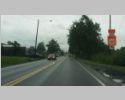
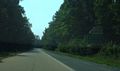
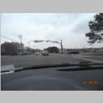
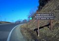
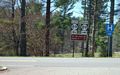
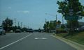
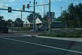
Located on US 250 heading up Afton Mtn. Pointed out to me originally by Amy Barden who says it showed up around November 2004. It was still there last time I checked in summer 2006 but gone by 2009. Taken by Mapmikey, 5/27/06. | ||
|
|
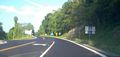
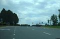
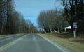
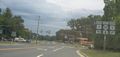
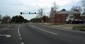
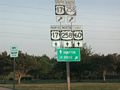
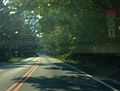
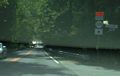
This is on US 29 SB near Woods Mill. Never seen a route shield with two leading zeros before...this has been here since at least 2012. Taken by Mapmikey, 6/25/15. | ||
|
|
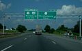
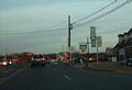
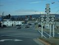
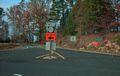
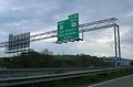
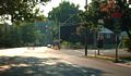
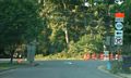
These three seriously misguided shields are near the north end of SR 641 in Loudon County. When the nearby interchange with Claiborne Pkwy was built, SR 641 was cut off from VA 7 and these signs were put up to get you over to VA 7. Taken by Mapmikey, 5/23/08. | ||
|
|
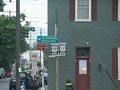
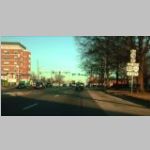
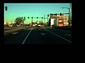
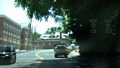
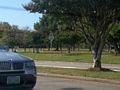
This is located in Tysons Corner Taken by Seth Dunn, April 2003. | ||
|
|
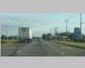
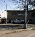
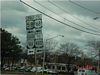
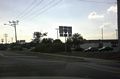
This is a very new BGS installed on I-81 northbound in Christiansburg. A West Virginia contractor perhaps? Was replaced by summer 2009. Taken by Mapmikey, 8/1/08. | ||
|
|
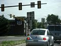
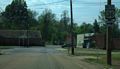
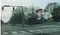
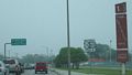
This is eastbound VA 10 just after crossing Appomattox River, Hopewell. The light in the distance is VA 36. Taken by Mapmikey, 5/5/06. | ||
|
|
|||
|
|
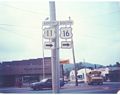
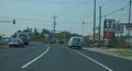
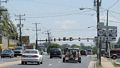
This is northbound US 11 in Marion. This shield looks fairly new. Marion was full of cutouts not too long ago, and in the early 90s there was a US 16 cutout error, though it wasn't at this intersection. Taken by Chris E, May 2006. | ||
|
|
I remembered this sign from a visit to Hungry Mother State Park in 1992 and Michael Summa got a picture of it from around that same timeframe. | ||
|
|
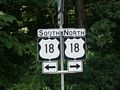
These two US 18 error shields date back to at least the mid-90s, at one of the few intersections in Covington with full sized shields. They were both still present July 2009. Taken by Mapmikey, 5/27/06. | ||
|
|
This error assembly is considerably newer and located south of Covington. Taken by HB Elkins, 6/27/07. | ||
|
|
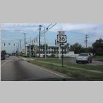
This is on VA 20 northbound at VA 20 Business in Orange. These shields date back to at least 1995 and were not corrected until the 2012-13 timeframe. Taken by Mapmikey, 1/17/07. | ||
|
|
|||
|
|
This US 22 shield is in Louisa and has been up since at least 2006 and still standing in 2013. Taken by Mapmikey, 2/15/08. | ||
|
|
|||
|
|
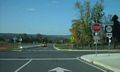
This US 33 shield is on the I-64 eastbound ramp at VA 249. This was relatively new then and is still up as of June 2012 GMSV. Taken by Mapmikey, July 2008. | ||
|
|
This is located on VA 33 near the MLK Bridge over I-95. Taken by Will Weaver, 1/9/08. | ||
|
|
This is located on US 250 at US 1-301, which crosses VA 33, not US 33. Taken by Will Weaver, 9/19/07. | ||
|
|
I don't guess the US 33-VA 33 dynamic will ever be posted correctly...these are located east of where VA 33 begins from Broad St and west of MCV. 1st photo taken by Mapmikey, 4/9/10, the other 6 taken on 3/2/13. | ||
|
|
|||
|
|
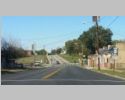
This is on VA 36 just before it turns to cross the Appomattox River. For a bonus, an SR 36 shield error in the background alerting motorists to bridge work. The second photo is from the opposite direction in Ettrick approaching the bridge. The entrance to the left is VA 327 and Virginia State University. Taken by Mapmikey, 4/24/07. | ||
|
|
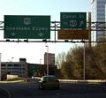
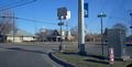
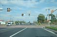
This is on US 301/US 460 bus approaching Wythe St in downtown Petersburg. This appeared in summer 2012. Taken by Michael Elmore, 9/29/12. | ||
|
|
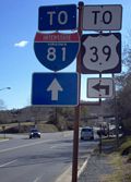
This is on US 60 westbound in Lexington at US 11 Bypass. This is the second version of a US 39 sign since the early 90s. This shield was gone in July 2009. Taken by Mapmikey, 1/26/06. | ||
|
|
Rocky Mount replaced a bunch of correct shields with a bunch of incorrect ones. Here are five oval 40 shield assemblies. When I passed through again in early 2009, they all seemed to be corrected. Taken by Mapmikey, 12/8/07. | ||
|
|
This is on SR 623 at SR 768 (old VA 42) in Columbia Furnace. The last time I had been at this intersection there was a sole VA 42 cutout here. The TO 263 posting puzzles me...are a lot of people trying to reach VA 263 via SR 623? Taken by Mapmikey, 4/19/10. | ||
|
|
There were several of these in the Eagle Rock area. The only other primary route I've seen posted with a lead zero is US 11 near Troutville. Taken by Mapmikey, 1/26/06. | ||
|
|
This Chase City error is that VA 49 south does not go straight at this junction; it is to the right. Taken by Mapmikey, 11/10/07. | ||
|
|
This is on US 211 westbound on top of Massanutten Mtn. The Forestry Service sign has had two versions over the years. Still standing as of April 2012 GMSV. Taken by Mapmikey, 3/18/06. | ||
|
|
This newer US 55 shield replaced a VA 55 cutout. Still standing as of April 2012 GMSV. Taken by HB Elkins, 6/28/07. | ||
|
|
There used to be a bunch of US 55 shields in Front Royal in the late 90s. Fortunately, Michael Summa got one for posterity. | ||
|
|
US 55 has returned to Front Royal! This was on US 340 SB approaching VA 55 and is shown as corrected in the May 2012 GMSV. Taken by Mapmikey, 6/5/10. | ||
|
|
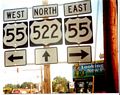
This was on VA 55 at US 522 in Front Royal and is shown as removed entirely in the May 2012 GMSV. Taken by Mapmikey, 6/5/10. | ||
|
|
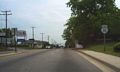
This is just after VA 16 in North Tazewell, in a 3-digit shield to boot! This goes back at least to 2002 and was still there in 2008 GMSV but I believe is gone now. Taken by HB Elkins, summer 2004. | ||
|
|
This is on US 58-360 WB near Danville. Taken by Mapmikey, 7/5/13. | ||
|
|
This is located on US 23-58-421 Business in Gate City. The TO VA 71 sign should be TO VA 72. This intersection is VA 71. This sign was still there Aug 2008 but gone in Oct 2008 GMSV. Taken by HB Elkins. | ||
|
|
This is on US 58 ALT and VA 75 leaving US 11 in Abingdon. This one is fairly recent. Unsigned US 58 Alternate is probably the inspiration for this gaffe, which is still up as of April 2013 GMSV. Taken by Nicholas Mooneyhan, June 2006. | ||
|
|
You can see the destruction of the original Grundy in this picture. The shield was not very old and was gone by Oct 2008 GMSV. Taken by Mapmikey, 8/18/07. | ||
|
|
This is at the Blue Ridge Pkwy and was still present in Jan 2009. Taken by Mapmikey, 4/13/07. | ||
|
|
This is just inside the Galax limits, a mile south of VA 97. Taken by Mapmikey, 1/21/09. | ||
|
|
|||
|
|
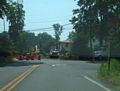
Located at the US 360-VA 92 crossroads east of Clover. The detour is in place because the VA 92 Roanoke River Bridge has been closed indefinitely. These all had correct shields by 2011. Taken by Mapmikey, 11/10/07. | ||
|
|
Located at SR 602 halfway between Fries and Ivanhoe. Taken by Mapmikey, 4/19/10. | ||
|
|
VA 99 has its own error page. | ||
|
|
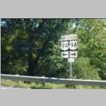
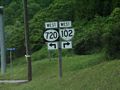
VA 102 has its own error page. | ||
|
|
This is on US 58-360 WB at Delila. Taken by Mapmikey, 7/5/13. | ||
|
|
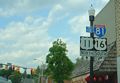
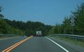
This is located on northbound I-81 in Ft. Chiswell and is new at time of photo. Still there in Oct 2012 GMSV. Taken by Chris E, May 2006. | ||
|
|
At a shopping center at the east end of the US 460 Bypass in Bedford I found these funny shaped VA 122 shields that may not be VDOT's creation. Still up as of June 2012 GMSV. Taken by Mapmikey, 1/21/07. | ||
|
|
Another Rocky Mount oval from their wholesale sign changeout. Taken by Mapmikey, 12/8/07. | ||
|
|
This is located on SR 610 northbound near Burke and dates back several years. Taken by Mapmikey, 5/24/07. | ||
|
|
|||
|
|
This has been in place several years in Colonial Heights. Entire assembly removed as of June 2012 GMSV. Taken by Mapmikey, 4/24/07. | ||
|
|
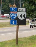
VA 144/TO I-95 unisign with an erroneous WEST banner in Colonial Heights. While technically going westbound here, VA 144 is nonetheless signed North/South everywhere. This first appeared around 2003, then disappeared a couple years later. It reappeared in 2008, then fell over at some point before being restored. Still there as of December 2011. Taken by Michael Elmore, 7/28/09. | ||
|
|
This is located on I-77 northbound ramp at VA 148 and was still there when I field visited in Dec 2013. As you can see in the second photo I took from then, the SR 775 shield has been corrected. Taken by Adam Froehlig, 7/23/02. | ||
|
|
This is located on US 1-301 northbound north of VA 145 and is a second generation LGS error. A correct shield is shown in the April 2012 GMSV. Taken by Mapmikey, 4/24/07. | ||
|
|
This is on US 60 WB at Providence Forge. Taken by Mapmikey, 10/6/12. | ||
|
|
VA 156 is erroneously detoured with a WEST banner. Reported as gone in summer 2012. Taken by Michael Elmore, 5/17/11. | ||
|
|
This is on VA 156 which is actually northbound in this picture leaving the SR 636/643 intersection. Another sign in the opposite direction was also wrong. Taken by Michael Elmore, 11/3/12. | ||
|
|
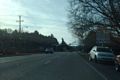
This was located on Quioaccasin Rd and had dated back to the 90s. In late 2007 both Dan F and Will Weaver alerted me this sign had been replaced with correct shields. Taken by Mapmikey, 4/26/06. | ||
|
|
This is located on US 33-250 in Richmond. This is a 3rd generation error sign that goes back to at least 1981! but a correct shield is finally present in the Aug 2011 GMSV. Taken by Mapmikey, 4/26/06. | ||
|
|
This was located on VA 165 south, Military Hwy. This is still shown as present on the June 2012 GMSV. Taken by Mapmikey, 4/7/06. | ||
|
|
This was located on VA 165 south, Little Creek Rd in Wards Corner. Shown as replaced with a flat-top interstate shaped shield by May 2012 GMSV. Taken by Adam Froehlig, 12/9/01. | ||
|
|
|||
|
|
Where US 460/VA 168 and VA 166 part ways. Taken by Mapmikey, 3/6/10. | ||
|
|
This is where VA 166 leaves Princess Anne Rd in Norfolk. Still up in May 2012 GMSV. Taken by L. Tillerman, early 2009. | ||
|
|
This was Tidewater Dr SB at Brambleton in Norfolk. Shown as replaced with a flat-top interstate shaped shield by May 2012 GMSV. Taken by L. Tillerman, early 2009. | ||
|
|
VA 168 north at US 58 in Norfolk. Shown as replaced with a flat-top interstate shaped shield by June 2012 GMSV. Taken by L. Tillerman, early 2009. | ||
|
|
This is on Tidewater Dr in Norfolk Taken by Deathtopumpkins. | ||
|
|
Where US 460 and VA 168 part ways. Taken by Mapmikey, 3/6/10. | ||
|
|
These are located at each direction on US 60 Little Creek. Field verified as present by Froggie in Dec 2013. Taken by Mapmikey, 4/26/07 and 4/18/08. | ||
|
|
|||
|
|
This was located on VA 225 south, Independence Blvd. This was here in 1991, but has finally been replaced with a flat-top interstate shaped shield by July 2011 GMSV.. Taken by Mapmikey, 4/7/06. | ||
|
|
Located south of VA 247. Taken by Mapmikey, 3/6/10. | ||
|
|
This is located on VA 195 just after leaving I-95 and is only a couple years old. Reported to have been corrected. Taken by Will Weaver. | ||
|
|
Norfolk just loves these interstate shields. These were still up in May 2012 GMSV. Taken by L. Tillerman, early 2009. | ||
|
|
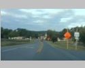
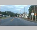
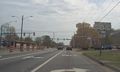
This is at the intersection with SR 628 Smith Station Rd near Spotsylvania C.H. It had been there several months at least and is verified to be present in summer 2013. Taken by Mapmikey, 10/10/10. | ||
|
|
The two error shields at VA 42 Timberville replaced cutout error shields. The others are in New Market. All of these are still up as of May 2012 GMSV. Taken by Mapmikey, 2/1/06 and 3/18/06. | ||
|
|
These are all on US 60 at VA 225's north end. The US 225 is fairly recent, but the circle shields (one now replaced with correct shield) go back to at least 1991. The other two error shields were also replaced by Aug 2011 GMSV. Taken by Mapmikey, 4/7/06 and 4/26/07. | ||
|
|
|||
|
|
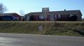
This is located at SR 609 Barco and was a fairly new assembly. Still standing as of June 2011 GMSV. Taken by Mapmikey, 11/10/05. | ||
|
|
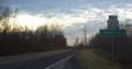
This is SR 655 WB in Somerset. Taken by Mapmikey, 4/23/13. | ||
|
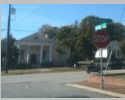
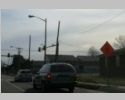
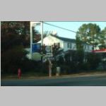
These are located in Manassas. The errors here are subtle...the BUSINESS banners are not present. Taken by Dan F, 3/8/08 and 7/14/08. | ||
|
|
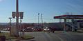
This is located on VA 123 southbound, Fairfax. These goes back to the mid 90s at least. The missing shield in the middle was a circle 123 as well. The Sept 2012 GMSV shows these as corrected. Taken by Mapmikey, 5/24/07. | ||
|
|
This is located on SR 600 eastbound, Lorton and was still there summer 2013. This oval goes back to at least 1995. Taken by Mapmikey, 5/25/06. | ||
|
|
This was located on VA 236 eastbound, Annandale. This was in place back to at least 1995; was gone when I drove by here in May 2007. Taken by Dan F, spring 2005. | ||
|
|
This was just after VA 7, Baileys Crossroads and has been here several years. Taken by Mapmikey, 5/23/08. | ||
|
|
This is on US 460. This is an error of placement. VA 247 runs on the cross streets while US 460 forges ahead. These signs were quite recent. This has been corrected. Taken by Mapmikey and Adam Froehlig, 4/7/06. | ||
|
|
This is from US 11 Business SB in Lexington. Still present on Aug 2012 GMSV. Taken by Mapmikey, 12/5/08. | ||
|
|
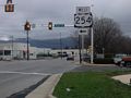
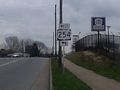
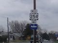
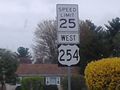
Waynesboro acquired some US 254 shields... #1 is at US 340 NB; #2 is just past US 250; #3 is approaching its westward turn onto Ivy St; #4 is at the turn; #5 is just after the turn. All were corrected by Aug 2012 GMSV. Taken by Kevin Macnutt, 3/30/11. | ||
|
|
This one was not very old when I found it on US 340 in Briggs. Gone by spring 2009. Taken by Mapmikey, 2/1/06. | ||
|
|
Captured by Jay Kibler in 2002. This entire assembly has been replaced. | ||
|
|
VA 258 ALT has two erroneous US 258 shields at its southern end. Taken by Adam Froehlig, 3/15/03 and Mapmikey 4/7/06. There is also an error shield after SR 626 (old VA 312), taken by Mapmikey 3/6/10. Not only are the first and last one still present as of Sept 2012 GMSV, the middle one has been moved to face the other direction implying US 258 business is actually US 258 ALT. Also, all the VA 258 ALT shields at VA 10 Business are shown on GMSV to also now be erroneous US 258 ALT shields. | ||
|
|
This was on US 58 ALT, St. Paul and was gone by April 1999. Taken by HB Elkins, October 1997. | ||
|
|
These are all on US 58-221 near Independence and looked really new. They were still there in early 2009. Taken by Mapmikey, 4/13/07. | ||
|
|
This is on US 58 westbound, Virginia Beach. In the early 90's there was no sign here at all. Taken by Mapmikey, 4/7/06. | ||
|
|
Here's a head scratcher. This VA 225 shield is located on VA 279 just south of First Colonial Rd (old VA 408). Shown as corrected in the Sept 2011 GMSV. Taken by El Spectro, 10/19/09. | ||
|
|
This is at the Lovettsville traffic square. Still present on Sept 2012 GMSV. Taken by Mapmikey, 10/23/08. | ||
|
|
These are all on VA 33 in West Point and were installed when the widening project on VA 33 was completed just prior to then. These were correct shields when Froggie and Mapmikey came by in Nov 2008. Taken by Mapmikey, 10/27/07. | ||
|
|
These were part of a detour created by a bridge replacement in Arlington near the Fairfax County line. Taken by Mapmikey, 7/10/07. | ||
|
|
This US 311 shield in Salem has been around for several years and was still there in May 2012 GMSV. Taken by Chris E, March 2004. | ||
|
|
This US 311 shield in is not quite as old and was still there in 2007, but gone by late 2008. Taken by Chris E, March 2004. | ||
|
This oddity is located about a quarter mile from the US 460 Bypass in Blacksburg, is why sign painters should avoid the 3 beer lunch...the second pic shows a wider view. The July 2012 GMSV shows no sign at all now. Taken by HB Elkins, spring 2003 and Mapmikey 12/8/07. | ||
|
|
These are one in each direction on VA 253 near Port Republic. This is at the farm extension facilty for JMU. There were also two normal 331 shields. Still present in summer 2011. Taken by Mapmikey, 1/17/07. | ||
|
|
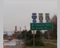
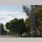
Here is a relatively recent posting of a double error...the US 337 shield and the fact that there is no VA 337 ALT here. Froggie reports in Dec 2013 the entire assembly is gone. Taken by Will Weaver, 2/15/08. | ||
|
|
The banners are swapped. Taken by Takumi. | ||
|
|
|||
|
|
This was a second generation sign. In 1991 this was a simple circle. This was a normal route shield when I drove by in April 2008. Taken by Adam Froehlig, 2/2/02. | ||
|
|
This was on SR 716 southbound near Dryburg. No other SR in the area has any shield with 344 at all. The Sept 2008 GMSV shows only the double arrow still on the post. Taken by Mapmikey, 7/22/06. | ||
|
|
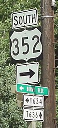
This was at the north end of VA 352 and was there at least 1998-2000. Taken by HB Elkins, summer 2000. | ||
|
|
This was at point where VA 358 splits into two prongs within the Woodrow Wilson Facility near Fishersville. While the shield is correct, the arrows are not. The other direction arrows are wrong too...they need to be switched with each other. Taken by Mapmikey, 1/21/06. | ||
|
|
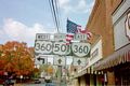
This erroneous US 360 shield in Halifax was captured by Jimmy Storey and has been replaced. | ||
|
|
This is leaving the Greensville Correctional Center in Jarratt as has been there back to at least 1995. This was fixed when I visited in March 2009. Taken by Rush Wickes, 7/3/03. | ||
|
|
Here are two VA 407 postings in Norfolk west of VA 168 where the route has never existed. Taken by Michael Elmore, 7/10/10. | ||
|
|
Not only an erroneous US 407 shield, this is also 1/2 mile west of where VA 407 ends. Taken by Will Weaver. |
Return to Error Signs main page.
![]()
![]()
Page last modified 30 October 2016
(C) 2017-2008 Mike Roberson, Adam Froehlig