< WV 45 | Home | WV 46 ALT | WV 46 SPUR | WV 47 >
|
|
|
| ROUTE LOG |
WV 42: 0 - 0 Maryland State Line: 11.9 - 11.9 GAP IN ROUTE Maryland State Line: 0 - 11.9 US 220: 5.3 - 17.2 WV 28: 15.7 - 32.9
|
Creation: Appeared in 1922 as new primary routing from WV 1 (now US 50) New Creek to the Maryland State Line at Piedmont. This is the only WV 46.
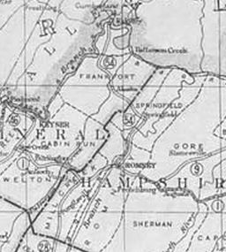
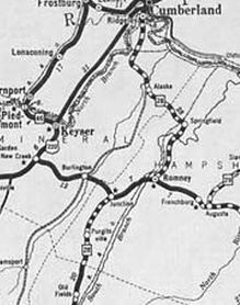
| Adjustments: Between 1929-31, WV 46 south was truncated to Keyser with the route to New Creek becoming part of US 220. Today this is WV 93; US 220; CR 220/5 Harley Stagger Sr Drive to Keyser; Newton St; S. Main St In 1932, WV 46 east was extended from Keyser to WV 28 Fort Ashby as new primary routing.
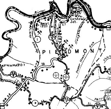
In 1933, WV 46 was extended west as new primary routing to the Maryland State Line at Beryl, with the Piedmont Crossing apparently removed from the highway system for a time. Also in 1933, WV 46 was removed from CR 46/11 Fountain Rd, CR 9 Headsville Rd, and CR 46/10 Cabin Run Rd as well as CR CR 46/5 Jake Staggers Rd and CR 11 Patterson Creek Rd through Reeses Mill 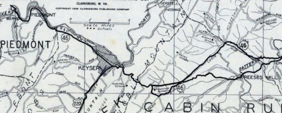
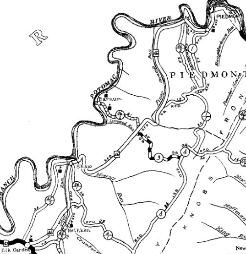
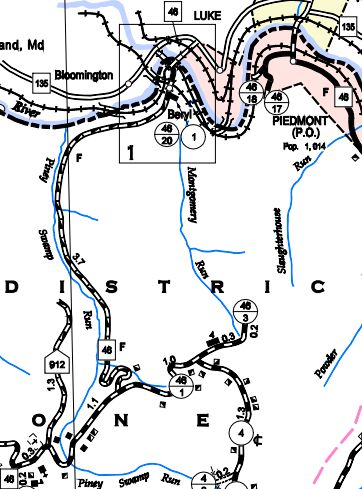
WV 46 changes in 1933 1933 Mineral County In 1934 or 1935, WV 46 was extended southwest to WV 42 Elk Garden as new primary routing, with the crossing at Beryl removed from the highway system for a time. In 1936 or 1937, WV 46 was removed from CR 46/8 Cemetary Rd and CR 14 Limestone Rd just east of Keyser. Between 1938-46, WV 46 was rerouted at Piedmont to replace CR 1 south to Piney Swamp Run. The old routing became CR 1 which did not connect back to WV 46 (shown as projected highway on the 1937 Mineral County Map). As early as 1951 (US 220 bridge relocated from Main St to current location), WV 46 was split into one-way pairs in Keyser: EB continues to use the original WV 46 routing of Piedmont/Main/Armstrong while WB uses Armstrong/Piedmont. About 1976, WV 46 was rerouted at Piedmont to head into Mayland as it does now, replacing WV 46 ALT. The route reappeared from Maryland at Beryl, replacing CR 1 and included newly reopened routing down to Piney Swamp Run essentially along its original 1930s path. This made WV 46 disconnected and requiring MD 135 to get between the pieces. The connecting piece between Beryl and Piedmont became CR 1 stub on the Beryl side and CR 46/17 on the Piedmont side.
About 1980, WV 46 was rebuilt on new alignments to avoid Jennings Randolph Lake. The access road to the dam for most of its length is on old WV 46 which used to go way up and curl around back south. In 1986, WV 46 was rerouted onto a new Potomac River Bridge to meet directly with MD 36 instead of Main St (MD 934). Improvements: By 1923, WV 46 was fully paved The Fort Ashby extension was paved by 1933 The extension to Elk Garden wasn't truly paved until 1980 from the lake south to WV 42; It is debatable whether the section north of the lake to Maryland is fully paved. No multilane segments on WV 46 Comment: So what's the point of the western segment of WV 46 anyway? There is a signed WV 46 TRUCK in Keyser for EB traffic that follows US 220 between Piedmont and Armstrong. |
||||||||||