


VA 91 in Tazewell County - The Substandard Road
On July 21, 2007 Mapmikey drove VA 91 south from US 19-460 Bus to VA 42. This page shows what he encountered.
|
|
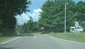
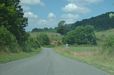
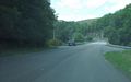
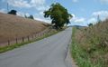
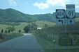
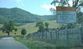
Approaching VA 91 from US 19-460 Business westbound. There was no indication one shouldn't use VA 91 as a through route, although there were no destination signs present either. |
|
|
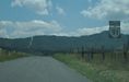
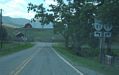
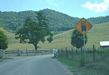
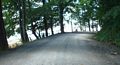
Initial VA 91 south reassurance. Here the road looks like a normal state highway, although the speed limit was 35. Note the warning for greater than 35 foot vehicles. |
|
|
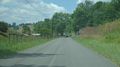
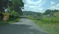
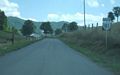
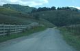
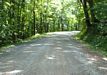
2 or 3 miles from US 19-460 Bus, VA 91 narrows greatly while still paved. |
|
|
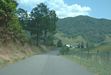
At the village of Liberty. The first primary highway in Virginia to use any part of today's VA 91 in Tazewell County was VA 119, assigned in 1924 and ran from US 19-460 Bus (was VA 11 then) to this point in Liberty. The 1925 Official Map shows this at paved then. |
|
|
Reassurance marker along VA 91. Primary routing was extended from Liberty over the rest of today's VA 91 in May 1926 when the original VA 105 was extended north from Saltville (although today's unpaved portion remained as a gap until 1927). |
|
|
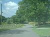
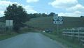
Approaching SR 608. |
|
|
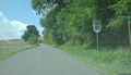
Reassurance after SR 608. On the substandard paved portion of VA 91, there are more reassurance shields than on just about any highway in Virginia. |
|
|
Another VA 91 south shot into a little glare. |
|
|
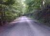
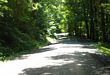
VA 91 south entering a woodsy patch. |
|
|
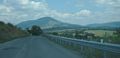
At the bridge over Little River. This is the only improved piece of VA 91 that meets modern standards. |
|
|
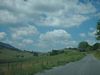
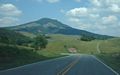
Looking west on SR 609 not far from VA 91 near Maiden Spring. The mountain on the left is Short Mountain. |
|
|
Looking east on SR 609 just before its descent to VA 91. The tall mountain is Morris Knob. |
|
|
At the VA 91 jct with SR 609, looking north towards Paint Lick Mountain. |
|
|
At the VA 91 jct with SR 609, looking south towards Clinch Mountain. |
|
|
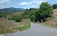
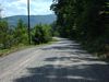
Another scenic view of VA 91 southbound. |
|
|
Just past the 3rd VA 91 jct with SR 608. The primary route (VA 105) was paved to this location by 1926. |
|
|
Just past the 4th and final VA 91 jct with SR 608. Again note the plethora of VA 91 reassurance signs on this stretch of yesteryear. I wonder if 10-15 years ago these were all cutouts...? |
|
|
Approaching a large farm near the base of Clinch Mountain. |
|
|
Approaching SR 604. |
|
|
Looking down SR 604 east which runs along Thompson Valley to VA 16. Again is Morris Knob which sits on the west end of Knob Mountain. Note the wider pavement and striping present on SR 604 that is lacking on Va 91. |
|
|
SR 604 west coming to an end at VA 91. There was no indication that large vehicles should NOT turn left. |
|
|
The view of VA 91 northbound approaching SR 604. |
|
|
Right after SR 604, the last warning for large vehicles. |
|
|
Approaching the end of pavement. |
|
|
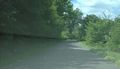
The transition from blacktop to gravel. Pavement was extended to this location on then-VA 81 by 1936. |
|
|
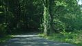
Ascending Clinch Mountain. Most of the gravel portion on this side of Clinch Mountain was in the shade. |
|
|
A typical layout of gravel 91 on the edge...no railing of any kind. |
|
|
This is a view looking back north at the VA 91-SR 604 intersection. We are about a mile by driving from the end of pavement. |
|
|
Still ascending Clinch Mtn. There are no side roads off of the gravel portion of VA 91. |
|
|
Nearing the top. I would've taken a picture of a sign of any sort, but there were NO postings of any kind on the entire gravel portion - only a sign at each end indicating squiggly curves next 5 miles. |
|
|
In the vicinity of the top. On the day I drove through, only 3 vehicles passed me going northbound on the gravel section. Even though I came to a complete stop for all the gravel pictures, nobody caught me from behind heading south. |
|
|
This is now on the descent. The condition of the gravel was pretty consistent throughout and did not have holes or washboard sections that I recall. |
|
|
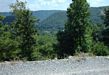
Looking southeast over the edge of VA 91, again with no railings. The mountain in the distance is Brushy Mtn. |
|
|
At the edge of a grazing pasture, where VA 91 clings closely to the mountain. VA 91 has been the only regular primary highway with an unpaved portion since 1955 when VA 99 west of Pulaski was decommissioned. The most recent 25 year plan on VDOT's website does not include paving VA 91, so this throwback segment will be around for a long time to come. |
|
|
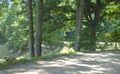
VA 91 getting back to its pavement near SR 607. The gravel portion is 5.3 miles and gravel continued south to the Smyth County Line until as late as 1950. |
|
|
The view of VA 91 northbound at the transition to gravel. The building here may have been Osborne's Store which is shown on the 1932 and 1936 Tazewell County Maps. |
|
|
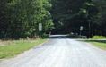
The fuzzy view of VA 91 northbound on Brushy Mountain a ways before the gravel segment. At 3 miles from the gravel segment, there was a yellow sign stating 3 miles to gravel road. A picture did not turn out and there was no corresponding sign from the southbound approach. |
|
|
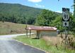
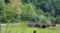
In southern Tazewell County VA 91 uses this 1924 bridge over Laurel Creek. |
|
|
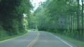
Just after the Smyth County line, VA 91 runs into VA 42. You can see the road here is more typical of Virginia Primary highways. |
![]()
![]()
Page last modified 16 September, 2007
(C) 2007 Mike Roberson, Adam Froehlig